- Marine spatial planning
-
Marine spatial planning (MSP) is a tool that brings together multiple users of the ocean – including energy, industry, government, conservation and recreation – to make informed and coordinated decisions about how to use marine resources sustainably. MSP uses maps to create a more comprehensive picture of a marine area – identifying where and how an ocean area is being used and what natural resources and habitat exist.
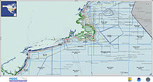 Example of MSP off Massachusetts, USA
Through the planning and mapping process of a marine ecosystem, planners can consider the cumulative effect of maritime industries on our seas, seek to make industries more sustainable and proactively minimize conflicts between industries seeking to utilise the same sea area. The intended result of MSP is a more coordinated and sustainable approach to how our oceans are used – ensuring that the seas marine resources and services are utilised, but within clear environmental limits to ensure marine ecosystems remain healthy and biodiversity is conserved.
Contents
Definition and concept
There are a number of definitions for marine spatial planning. According to the United Nations Educational, Scientific, and Cultural Organization, marine spatial planning is a public process of analyzing and allocating the spatial and temporal distribution of human activities in marine areas to achieve ecological, economic, and social objectives that usually have been specified through a political process. Essentially, marine spatial planning is a planning tool that enables integrated, forward-looking and consistent decision-making on the use of the sea. Numerous countries around the globe are embracing this tool to combat crowded usage of their territorial sea waters.
The United Kingdom's Department of Environment, Food and Rural Affairs has developed a commonly used definition:
“strategic, forward-looking planning for regulating, managing and protecting the marine environment,including through allocation of space, that addresses the multiple, cumulative, and potentially conflicting uses of the sea” (DEFRA, 2004,3)
The main elements of marine spatial planning include an interlinked system of plans, policies and regulations; the components of environmental management systems (e.g. setting objectives, initial assessment, implementation, monitoring, audit and review); and some of the many tools that are already used for land use planning. Whatever the building blocks, the essential consideration is that they need to work across sectors and give a geographic context in which to make decisions about the use of resources, development, conservation and the management of activities in the marine environment (JMPMU 55, 2007).
Effective marine spatial planning has essential attributes:
- Multi-objective. Marine spatial planning should balance ecological, social, economic, and governance objectives, but the over riding objective should be increased sustainability.
- Spatially focused. The ocean area to be managed must be clearly defined, ideally at the ecosystem level - certainly being large enough to incorporate relevant ecosystem processes.
- Integrated. The planning process should address the interrelationships and interdependence of each component within the defined management area, including natural processes, activities, and authorities.
Marine spatial planning in the United Kingdom
The Marine and Coastal Access Act 2009 [1] defined arrangements for a new system of marine management, including the introduction of marine spatial planning, across the UK. Although the new system comprises the principles of marine spatial planning as articulated by the European Commission, it is commonly referred to in the UK simply as 'marine planning'.
Among the Government's stated aims for the new marine planning system is to ensure that coastal areas, the activities within them and the problems they face are managed in an integrated and holistic way. This will require close interaction with town and country planning regimes and, in England and Wales, the new regime for Nationally Significant Infrastructure Projects (NSIPs) in key sectors, such as energy and transport.
The Marine Policy Statement
The cornerstone of the UK marine planning system is the Marine Policy Statement (MPS)[2]. It sets out the sectoral/activity specific policy objectives that the UK Government, Scottish Government, Welsh Assembly Government and Northern Ireland Executive are seeking to achieve in the marine area in securing the UK vision of 'clean, healthy, safe, productive and biologically diverse oceans and seas.'
The MPS is the framework for preparing Marine Plans and taking decisions that affect the marine environment in England, Scotland, Wales and Northern Ireland. It will also set the direction for new marine licensing and other authorisation systems in each administration. It is proposed that the draft MPS, which was subject to consultation in 2010, will be formally adopted as Government policy in 2011.
The Marine Management Organisation
In England, the new arrangements provide for the creation of the Marine Management Organisation (MMO), which started work in April 2010. The MMO will deliver UK marine policy objectives for English waters through a series of statutory Marine Plans and other measures. The first Marine Plans will start to be prepared by the MMO on adoption of the MPS in 2011. The UK Government's Consultation on a marine planning system for England [3] document provides, for the benefit of the MMO and other interested parties, more detail on the scope, structure, content and process envisaged for each Marine Plan.
Marine spatial planning in the United States
On June 12, 2009, President Obama created an Interagency Ocean Policy Task Force to provide recommendations on ocean policy, including MSP. The President’s memorandum can be found online at:[4]
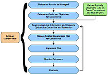 A graph showing the US marine spatial planning process
Some individual states have already undertaken MSP initiatives:
Massachusetts
The Massachusetts Ocean Act, enacted in May 2008, requires the secretary of the Massachusetts Office of Energy and Environmental Affairs to develop a comprehensive ocean management plan. The plan will be submitted to NOAA for incorporation into the existing coastal zone management plan and enforced through the state’s regulatory and permitting processes, including the Massachusetts Environmental Policy Act (MEPA) and Chapter 91, the state’s waterways law.
The goal is to institute a comprehensive approach to ocean resource management that supports ecosystem health and economic vitality, balances current ocean uses, and considers future needs. This will be accomplished by determining where specific ocean uses will be permitted and which ocean uses are compatible.
California
In 1999, the California state legislature adopted the Marine Life Protection Act. This action required the state to undertake a marine spatial planning effort to evaluate and possibly redesign all existing state marine protected areas and to potentially create new protected areas that could, to the greatest degree possible, act as a networked system. (Marine protected area designations in California include state marine reserves, marine parks, and marine conservation areas.)
Oregon
Two controversial ocean issues led to a marine spatial planning effort: concern by fishermen over the designation of marine reserves off the Oregon coast, and proposals by industry to site wave energy facilities in Oregon ocean waters.
An executive order directed the Oregon Department of Land Conservation and Development to work with stakeholders and scientists to prepare a plan for ocean energy development (also known as wave energy). This plan was then to be adopted as part of the Oregon Territorial Sea Plan.
The state has appointed an advisory committee and expects to adopt the plan in early 2010. It will include mandatory policies for state and federal agency decisions with regard to locating ocean energy facilities in the Oregon Territorial Sea.
Tools
There are a number of useful and innovative tools that can help managers implement marine spatial planning. Some include:
- NOAA's Multipurpose Marine Cadastre
- NOAA's Digital Coast: Legislative Atlas
- Australia's Maxran Software
- Marine Map.org's Google-interface product
- USCB's Global Map of Human Impacts to Marine Ecosystems
- Duke University's Marine Geospatial Ecology Tools
- Center for Ocean Solutions' Collaborative Geospatial Information and Tools
See also
External links and references
- ABPmer's Marine Planning Site
- UNESCO International Ocean Council MSP Guide
- NOAA's MSP Information Site
- Marine Spatial Planning from Plymouth Marine Institute
- White House Memorandum creating Interagency Ocean Policy Task Force
References
ABPmer (2005), Marine Spatial Planning Pilot Literature Review Peterborough. Online:http://www.abpmer.net/mspp
ABPmer (2006), Marine Spatial Planning Pilot Final Report. Peterborough. Online:http://www.abpmer.net/mspp
Joint Marine Programme Marine Update 55 (2007): Marine Spatial Planning: A down to earth view of managing activities in the marine environment for the benefit of humans and wildlife
Long R. (2007) .Marine Resource Law. Dublin: Thompson Round Hall
Gubbay S. (2004) .Marine protected areas in the context of marine spatial planning— discussing the links. A report for WWF-UK Online: http://www.wwf.org.uk/filelibrary/pdf/MPAs-marinespacialplanning.pdf
Douvere, F and Ehler, C. (2006) The International perspective: Lessons From Recent European Experience With Marine Spatial Planning, paper presented at the Symposium on Management for Spatial and Temporal Complexity in Ocean Ecosystems in the 21st Century at the 20th Annual Meeting of the Society for Conservation Biology, San Jose, California, 24–28 June 2006
Categories:


Wikimedia Foundation. 2010.