- Cape Verde–Mauritania Maritime Delimitation Treaty
-
Cape Verde – Mauritania Maritime Delimitation Treaty Treaty on the Delimitation of the Maritime Frontier between the Islamic Republic of Mauritania and the Republic of Cape Verde 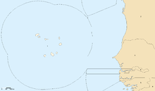
Maritime boundaries of Cape Verde, Mauritania, and neighboring countries. Type boundary delimitation Signed 19 September 2003 Location Praia, Cape Verde Parties  Cape Verde
 Mauritania
Depositary  United Nations Secretariat
Languages Arabic; French; Portuguese The Cape Verde – Mauritania Maritime Delimitation Treaty is a treaty between Cape Verde and Mauritania in which the two states agreed to the delimitation of their maritime boundary.[1]
The treaty was signed at Praia on 19 September 2003 and was ratified by Cape Verde on 23 April 2004. The boundary is approximately 160 nautical miles long and trends north–south; the treaty defines it in explicit maritime segments using 18 specific points.
The official name for the treaty is Treaty on the Delimitation of the Maritime Frontier between the Islamic Republic of Mauritania and the Republic of Cape Verde.
Notes
- ^ Charney, Jonathan I. et al. (2005). International Maritime Boundaries, pp. 3694–3707.
References
- Charney, Jonathan I., David A. Colson, Robert W. Smith. (2005). International Maritime Boundaries, 5 vols. Hotei Publishing: Leiden. 10-ISBN 0792311876/13-ISBN 9780792311874; 10-ISBN 904111954X/13-ISBN 9789041119544; 10-ISBN 9041103457/13-ISBN 9789041103451; 10-ISBN 9004144617/13-ISBN 9789004144613; 10-ISBN 900414479X/13-ISBN 9789004144798; OCLC 23254092
External links
Categories:- 2003 in Cape Verde
- 2003 in Mauritania
- Borders of Cape Verde
- Borders of Mauritania
- Boundary treaties
- Treaties of Cape Verde
- Treaties of Mauritania
- Treaties concluded in 2003
- Cape Verde stubs
- Mauritania stubs

Wikimedia Foundation. 2010.