- Capitol Hill (Salt Lake City)
-
Coordinates: 40°46′40″N 111°53′20″W / 40.77778°N 111.88889°W
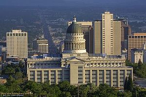 View of the Utah State Capitol building looking south down State Street. Downtown skyscrapers are shown behind the west side of the Capitol. The Utah State Archive Building obstructs part of the Capitol in this view.
Capitol Hill in Salt Lake City gets its name from the Utah State Capitol prominently overlooking downtown. In addition, Capitol Hill can be considered a neighborhood of Salt Lake City.
Contents
Geography
The hill slopes down to the south so that it handsomely overlooks the Salt Lake City downtown area. The Utah State Capitol, which the hill is now named after, was built from 1912 to 1916 in the prime spot to overlook the city. State Street, a road which runs through the whole state as highway 89, leads up Capitol Hill toward the Capitol which can be seen from miles away as the symbolic end of State Street. Main Street also climbs Capitol Hill one block to the west. The entire Salt Lake City metro area is impressively seen from Capitol Hill, and the Great Salt Lake glistens miles to the west.
The hill is home to many historic buildings. The west sloping side of the hill is called "Marmalade Hill", since the streets are named after various fruits that are often used in making marmalade. It is renowned as a uniquely diverse neighborhood. The east slope descends sharply into City Creek Canyon. Over the small canyon is another Salt Lake City neighborhood called "the Avenues". Above and to the north of the Capitol building is the Wasatch Springs area named after nearby natural hot springs. The sloping south face of Capitol Hill is sometimes called "Heber's Bench" after Heber C. Kimball, former resident and Apostle of The Church of Jesus Christ of Latter-day Saints.
The Marmalade District's borders are generally considered to be a small triangular area bounded by 300 North on the south, 500 North on the north, Center Street on the east, and Quince Street, the district's "Main Street", on the west. [1]
Demographics
Marmalade District
The western slope of Capitol Hill is called the "Marmalade District" after marmalade fruit jam because of the streets named after fruit trees imported and planted there such as apricot, quince and almond. Most of the original streets of Salt Lake City are aligned to and named after cardinal directions, and exceptions to this rule are often named. The Avenues are one example. The irregular, narrow, and steep roads of the Marmalade District are another.
The district is often considered among the most architecturally diverse in Utah residential neighborhoods. Early examples of Utah vernacular architecture sit alongside diverse turn-of-the-century styles such as a Russian-influenced LDS meeting house, Gothic revival homes, Victorian mansions, and eclectic houses of various combinations of adobe, brick, and carpentry.
Notable buildings and sites on Capitol Hill
- Utah State Capitol
- Salt Lake City Council Hall - old Salt Lake City Hall relocated from downtown to across from the capitol building.
- White Memorial Chapel - 1883 Latter-day Saint 18th ward Gothic revival chapel that was privately rebuilt across from Capitol building for non-denominational services.
- Pioneer Memorial Building - home of Pioneer History Museum, and a replica of the Old Salt Lake City Theater.
- Kimball-Whitney Cemetery - a small cemetery for the Kimball and Whitney families, which is the final resting place of Heber C. Kimball.
- Dickson-Gardner-Wolf Home - large 1905 Classic revival mansion on East Capitol Street for US District Attorney William H. Dickson.
- Alfred McCune Home - 1901 Main Street mansion for Indian-born railroad and mining businessman Alfred W. McCune.
- Ashby Snow Home - 1909 State Street prairie-style mansion built for LDS apostle.
- Woodruff-Riter-Stewart Home - 1906 second renaissance revival State Street mansion.
In the Marmalade District
- 19th Ward Chapel - Russian-influenced Latter-day Saint (LDS) chapel featuring "onion dome" steeple. (List of Registered Historic Places in Utah)
- 19th Ward Relief Society Hall - the last remaining separate LDS Relief Society hall. The 19th Ward Chapel and Relief Society Hall are today the home of the Salt Lake Acting Company, or SLAC, one of two professional theatre companies in Utah.
- John Platts Home - a very early 1856 vernacular adobe house with an 1860 fired brick second story added when bricks first became available in Utah. (List of Registered Historic Places in Utah)
- Morrow-Taylor Home – c. 1868 Victorian Italiante home once allegedly the residence of LDS church president John Taylor while evading federal authorities.
- Richard Vaughen Morris Home - 1860s adobe house of Nauvoo Legionnaire Richard Vaughen Morris. (List of Registered Historic Places in Utah)
- Thomas Quayle Home - 1884 gothic mansion relocated in 1975 from downtown.
Also of note
- Memory Grove - A park dedicated in 1920 to the victims of World War I. Memory grove is in a small canyon immediately east of Capitol Hill.
Capitol Hill Today
Events
Throughout the summer, the Capitol Preservation Board offers "Movie Under the Stars." This is an outdoor movie series that shows different types of movies. This summer, there has been Kung Fu Panda, My Big, Fat, Greek Wedding, Shrek the Third and Ant Bully. The last two are Iron Man on August 12, and Bedtime Stories on August 29. The movies are shown on a blowup screen on the south lawn of Capitol Building.
Also, during the summer, the Capitol Preservation Board hosts Capitol Discovery Day. It is a day to come up and see the Capitol Building and enjoy fun games and activities. Throughout the day there is bands playing and choirs singing inside. This year, it is on August 29 and starts at noon and ends with "Movie Under the Stars."
Crime
The Capitol Hill District has a low crime rate and is patrolled often by the Salt Lake City Police Department.
The future
Capitol Hill Neighborhood Council
Capitol Hill Neighborhood Council website
Famous people from Capitol Hill
References
- ^ Utah.com. "Utah .". utah.com. Archived from the original. Error: If you specify
|archiveurl=, you must also specify|archivedate=. http://www.utah.com/culture/marmalade_district.htm.
External links
Salt Lake City Information Buildings and sites · Climate · Education · Notable citizens · Geography · History · Libraries · Mayors · Media · TransportationNeighborhoods 9th and 9th · The Avenues · Capitol Hill · Central City · Downtown · Foothill · Federal Heights · Glendale · Poplar Grove · Rose Park · Sugar HouseSports Teams Entertainment The DepotCategories:- Neighborhoods in Salt Lake City, Utah

Wikimedia Foundation. 2010.