- Baltimore–Washington Parkway
-
Maryland Route 295
Baltimore–Washington Parkway 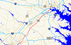
The Baltimore–Washington Parkway highlighted in red.Route information Maintained by National Park Service, MDSHA, Baltimore DOT Length: 32.52 mi[1][2][3][4] (52.34 km) Major junctions South end: 
 US 50 / MD 201 in Cheverly, Maryland
 I-95 / I-495 in Greenbelt Park
 MD 32 near Fort Meade
 MD 175 near Fort Meade
 MD 100 in Hanover
 I-195 near BWI Airport
 I-695 in Linthicum
 I-895 near Baltimore
I-95 in BaltimoreNorth end: 
 US 40 / MD 129 in Baltimore
Highway system Maryland highway system
Interstate • US • State • Minor • Former • Turnpikes←  I-295
I-295I-297  →
→The Baltimore–Washington Parkway (also referred to as the B–W Parkway) is a highway in the U.S. state of Maryland, running southwest from Baltimore to Washington, D.C. The road begins at an interchange with U.S. Route 50 and Maryland Route 201 near Cheverly in Prince George's County at the D.C. border, and continues northeast as a parkway maintained by the National Park Service (NPS) to Maryland Route 175 near Fort Meade, serving many federal institutions. This portion of the parkway is dedicated to Gladys Noon Spellman, a representative of Maryland's 5th congressional district, and has the hidden Maryland Route 295 designation. Commercial vehicles, including trucks, are prohibited within this stretch. After leaving park service boundaries the highway is maintained by the state and signed with the MD 295 designation. This section of the parkway passes near Baltimore–Washington International Thurgood Marshall Airport. Upon entering Baltimore, the Baltimore Department of Transportation takes over maintenance of the road and it continues north to an interchange with I-95. Here, the Baltimore–Washington Parkway ends and MD 295 continues north unsigned on Russell Street, which carries the route north into downtown Baltimore. In downtown Baltimore, MD 295 follows Paca Street northbound and Greene Street southbound before ending at U.S. Route 40.
Plans for a parkway linking Baltimore and Washington date back to Pierre Charles L'Enfant's original layout for Washington D.C. in the 18th century but did not fully develop until the 1920s. Major reasons surrounding the need for a parkway included high accident rates on adjacent U.S. Route 1 and defense purposes before World War II. In the mid-1940s, plans for the design of the parkway were finalized and construction began in 1947 for the state-maintained portion and in 1950 for the NPS-maintained segment. The entire parkway opened to traffic in stages between 1950 and 1954. Following the completion of the B–W Parkway, suburban growth took place in both Washington and Baltimore. In the 1960s and the 1970s, there were plans to give the segment of the parkway owned by the NPS to the state and make it a part of Interstate 295 and possibly I-95; however, they never came through and the entire road is today designated as MD 295, despite only being signed on the state portion. Between the 1980s and the 2000s, the NPS portion of the road was modernized and a part of signed MD 295 is in the process of being widened from four to six lanes, with more widening and a new interchange along this segment planned for the future.
Contents
Route description
NPS segment
The parkway begins at a large hybrid cloverleaf just outside the Washington, D.C. boundary at Tuxedo, Maryland that is maintained by the Maryland State Highway Administration.[1] Two routes converge at the southern and western ends of the interchange: U.S. Route 50, which heads west into Washington, D.C. to become New York Avenue; and Maryland Route 201, which begins at the D.C. line along the northernmost tip of the Kenilworth Avenue Freeway (which continues into the District of Columbia as D.C. Route 295). US 50 continues east from this interchange as the John Hanson Highway, a freeway, and MD 201 continues north on Kenilworth Avenue, a surface road that closely parallels the B–W Parkway to the east past the interchange.[1][5]
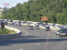
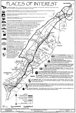
The portion of the B–W Parkway between the southern terminus and Maryland Route 175 is maintained by the National Park Service (NPS). It continues north as a six-lane 45 mph (72 km/h) limited-access parkway with the secret Maryland Route 295 designation, containing brown signs featuring the Clarendon typeface.[1][5] Along this section of the parkway, commercial vehicles such as trucks are prohibited; however, buses and limousines are allowed.[6][1] The parkway heads through wooded surroundings near industrial areas and passes over MD 201, where there is a ramp from southbound MD 201 to the southbound B–W Parkway. It continues northeast, passing near Prince George's Hospital Center, to interchanges with Maryland Route 202 (Landover Road) in Cheverly and with Maryland Route 450 (Annapolis Road) in Bladensburg near the former Capital Plaza Mall.[5] Bladensburg itself is a historical waterfront town that consists of houses dating back to the mid-18th century.[7] It continues north as a four-lane 55 mph (89 km/h) road with a wide, tree-filled median, and passes through woodland, skirting residential neighborhoods hidden by the trees. The road has a junction with Maryland Route 410 (Riverdale Road) west of New Carrollton.[1][5] This route provides access to the towns of Riverdale Park, which features an 1801 mansion named Riversdale surrounded by suburban development, and Hyattsville, which has buildings dating back to the railroad days of the 1870s and the streetcar and automobile days of the early 20th century.[7] North of here, the route runs near more residences before entering Greenbelt, a suburban garden community built as a model "green town" during the New Deal program in the 1930s, and Greenbelt Park, a park under the jurisdiction of the NPS that has the nearest public camping area to Washington, D.C.[5][7] In the northeastern corner of the park, the Baltimore–Washington Parkway comes to an interchange with Interstate 95 and Interstate 495 (the Capital Beltway).[5] This interchange is the only place where the park service has used green signs compliant with the Manual on Uniform Traffic Control Devices (MUTCD).[1][5]
Just past the Capital Beltway, the route heads into the heart of the city of Greenbelt, having an interchange with Maryland Route 193 (Greenbelt Road).[1][5] The headquarters of the U.S. Park Police, which patrol this portion of the parkway, is located off this exit along MD 193.[8] MD 193 provides access to College Park, which is home to the College Park Airport, a 1909 airport where the Wright Brothers taught the U.S. Army how to fly an airplane, and the University of Maryland, College Park, a public educational institution established in 1862.[7] At the northern edge of the town, the route has employee-only access to the Goddard Space Flight Center, the first NASA space flight center opened in 1958 that contributed majorly to many space missions; from here, the route then enters the Beltsville Agricultural Research Center, the largest agricultural research center in the world owned by the United States Department of Agriculture.[5][7] The parkway's only interchange within the center is at Powder Mill Road, south of Capitol College.[1][5]
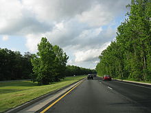 Northbound Baltimore–Washington Parkway between Powder Mill Road and MD 197.
Outside the Beltsville Agricultural Research Center, the parkway comes to Maryland Route 197 (Laurel–Bowie Road) south of Laurel.[1][5] Near this exit of the parkway is the Montpelier Mansion, a Georgian mansion built by Major Thomas Snowden in 1783.[7] Past MD 197, the road passes through the western edge of the Patuxent National Wildlife Research Refuge, a wildlife center established in 1936 by President Franklin D. Roosevelt, crossing the Patuxent River into Anne Arundel County.[5][7] Here the parkway continues northeast through dense woodland and comes to the exit for Maryland Route 198 (Fort Meade Road) to the east of Laurel, which itself is a suburb that originated in the 1830s as a mill town that contains many historical sites such as the Laurel Railroad Station (still used today by MARC Train), a 1844 Queen Anne house, and an 1840s millworkers house that is home to the Laurel Museum.[7] Continuing north, the parkway encounters Maryland Route 32 (Savage Road) near Fort Meade.[2][5] MD 32 offers northbound travelers direct access into the fort and to the National Security Agency, while the next interchange, another employee-only access road into Fort Meade, features only a southbound exit and northbound entrance.[5] Fort Meade itself is a military installation opened in 1917 that trained 3.5 million troops during World War II and is still a major fort. To the west of the parkway off MD 32 is the Savage Mill, which was an operating cotton mill from 1822 to 1947 and is currently an antique mall, and the Bollman Truss Railroad Bridge, an 1869 cast and wrought iron bridge along the Baltimore & Ohio Railroad (now CSX) line between Baltimore and Washington D.C.[7] After this interchange, the road continues to a cloverleaf interchange with Maryland Route 175 (Jessup Road), where NPS maintenance of the parkway comes to an end at the south end of the interchange.[2][5]
Maryland Route 295
Past the MD 175 junction, Maryland Route 295 signage begins and the road continues north as a four-lane grade-separated freeway maintained by the Maryland State Highway Administration, where the truck ban ends. This section of the road features standard MUTCD green signage. It heads through wooded areas and comes to Maryland Route 713F (Arundel Mills Boulevard), which provides access to the Arundel Mills shopping mall at a dumbbell interchange. Past this interchange, MD 295 comes to a cloverleaf interchange with Maryland Route 100. Continuing northeast, the route curves to the northwest of Baltimore–Washington International Airport (the largest airport in Maryland), passing near an industrial park before reaching Interstate 195, the main access road to the airport.[2][5][7] Within this interchange, before passing under I-195, the road crosses over Amtrak's Northeast Corridor.[5] I-195 westbound provides access from the Baltimore–Washington Parkway to the Thomas Viaduct, which carries the B&O railroad line over the Patapsco River, and Patapsco Valley State Park, a 14,000-acre (57 km2) state park that preserves the valley of the Patapsco River for recreational purposes.[7]
Still on a northeast track, the route intersects West Nursery Road near Linthicum, adjacent to the BWI Hotel District. Past West Nursery Road, the road meets Interstate 695 (the Baltimore Beltway) at a full cloverleaf interchange. Turning north, the route widens to six lanes and passes under Maryland Route 168 (Nursery Road) before crossing the Patapsco River into Baltimore County.[2][5] Upon crossing into Baltimore County, MD 295 reaches a partial interchange with Interstate 895 (Harbor Tunnel Thruway), with access from northbound MD 295 to northbound I-895 and from southbound I-895 to southbound MD 295. Past I-895, the road continues through wooded surrounding with residential developments behind the trees, before entering the city of Baltimore.[3][5]
In Baltimore, MD 295 continues as a limited-access freeway maintained by the Baltimore Department of Transportation, still surrounded by trees with urban residential and industrial neighborhoods nearby and interchanging with Maryland Route 648 (Annapolis Road) and Waterview Avenue just beyond the city line. Now running due north, the parkway soon reaches its northern terminus at Interstate 95, where MD 295 downgrades from a limited-access freeway to a six-lane 35 mph (56 km/h) undivided city street called Russell Street.[4][5]
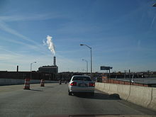 MD 295 southbound on Russell Street in Baltimore.
MD 295 continues northeast on Russell Street, where it is unsigned for the remainder of the route, through a mix of industrial and commercial areas before turning into a divided highway and passing to the west of M&T Bank Stadium, where the Baltimore Ravens of the National Football League play. Past here, the road features an interchange with Martin Luther King Jr. Boulevard, which becomes Interstate 395 south of Russell Street.[5] After this interchange, MD 295 runs west of Oriole Park at Camden Yards, home to Major League Baseball's Baltimore Orioles, as a four-lane divided street.[5] Immediately after Camden Yards, MD 295 splits into a one-way pair at the intersection with Washington Boulevard with northbound traffic following Paca Street and southbound traffic following Greene Street.[4][5] Along the one-way pair, the route intersects many major streets in downtown Baltimore, including Pratt Street, Lombard Street, Baltimore Street, Fayette Street, and Saratoga Street.[5]
Greene Street passes the University of Maryland Medical Center between Lombard Street and Baltimore Street, the Baltimore VA Medical Center between Baltimore Street and Fayette Street, and Westminster Hall and Burying Ground at the corner of Fayette Street. Paca Street passes by the Sonneborn Building north of Pratt Street; the Heiser, Rosenfeld, and Strauss Buildings north of Lombard Street; the historic Paca Street Firehouse and Sanitary Laundry Company Building just north of the intersection with Fayette Street; and Lexington Market at the intersection with Lexington Street.[5] MD 295 officially ends at U.S. Route 40, which follows Mulberry Street eastbound and Franklin Street westbound, in downtown Baltimore. Maryland Route 129 continues north from the northern terminus of MD 295, following Paca Street northbound and Pennsylvania Avenue southbound.[4][5]
History
Planning
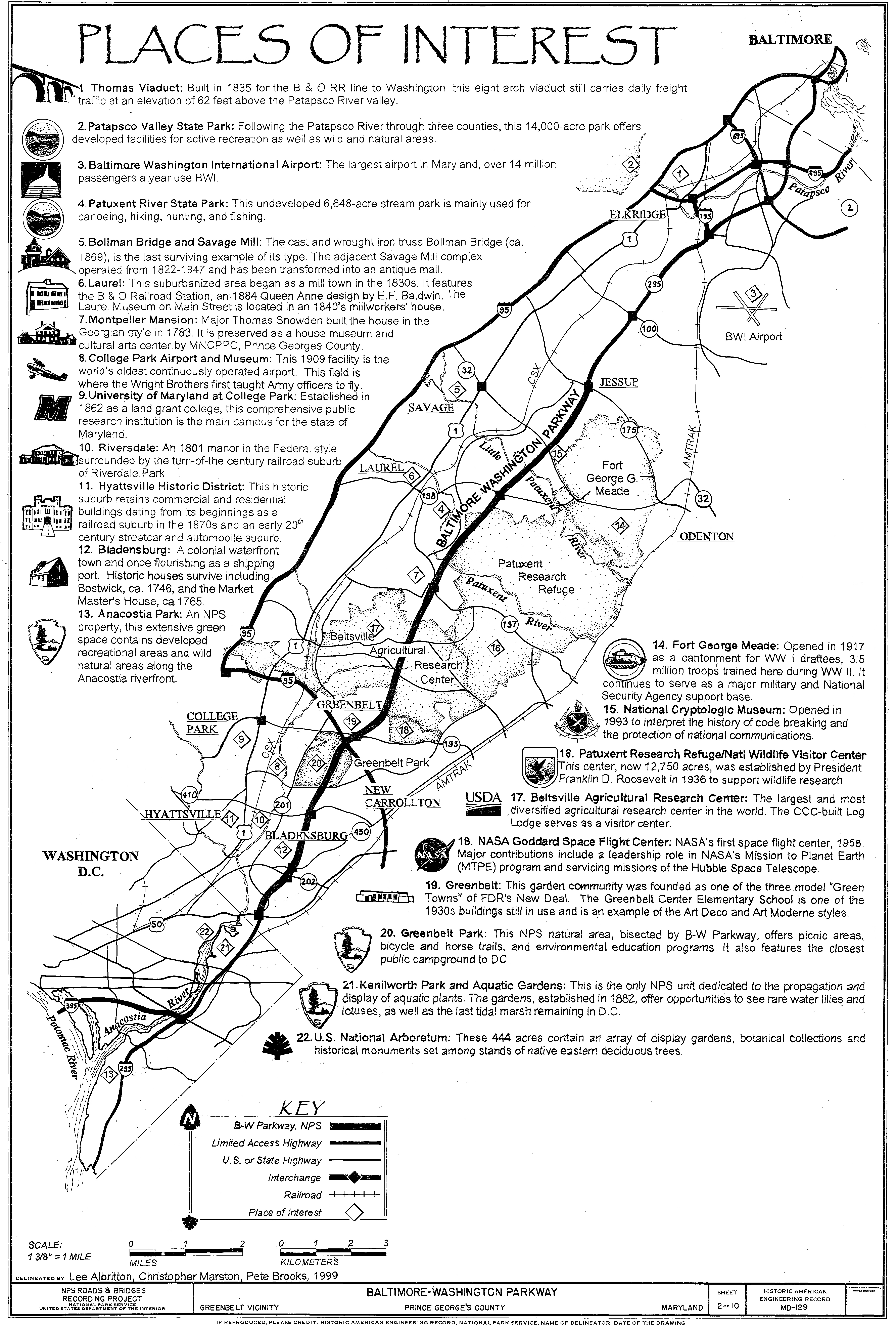
 Map of the Baltimore–Washington Parkway from the National Park Service.
Plans for a parkway connecting Baltimore and Washington date back to the 1920s as a part of a system that was initially included in Pierre Charles L'Enfant's layout of Washington, D.C from the 18th century.[9] In 1924, Harry W. Nice, who would later become Governor of Maryland, called for the parkway to be constructed.[10]
Early proposals made by the National Capital Park and Planning Commission involved a route that followed U.S. Route 1 north to MD 198, then east to Fort Meade, but lack of funding led to simpler plans to widen US 1 instead. During the 1930s, the New Deal programs promulgated by President Franklin Roosevelt led to a heightened awareness of the parkway proposals; a 1937 report by the Maryland State Planning Commission increased awareness further.[11] Increasing accident levels on US 1 (which was called one of the deadliest roads in the world at the time) along with awareness of the need to mobilize national defense before World War II provided additional motivation for construction of the parkway.[12][13]
In 1942, the Bureau of Public Roads began the process to start the construction design for the parkway.[14] Federal and state officials commissioned the firm J.E. Greiner to create designs for the parkway, which included a large Y-junction at the southern terminus to connect with New York Avenue and the proposed Anacostia Freeway. Meanwhile, the northern end included a similar wye, with one end running to US 40 (Franklin Street) and the other end crossing the Inner Harbor, but this was modified in 1945 to the current configuration.[15]
Construction
Construction on the northern portion of the highway began in 1947 by the state of Maryland, while construction on the NPS segment started in 1950.[15] The land for the portion that was to be built by the NPS was acquired at the same time as Greenbelt Park, a park that is under the jurisdiction of the NPS.[16] The state-maintained portion was completed in December 1950 between Maryland Route 46 (now I-195) and Hollins Ferry Road at the Baltimore city line and in 1952 from MD 175 to MD 46. The portion of the parkway within the city of Baltimore opened in 1951 while the NPS-maintained portion opened in October 1954.[10] The portion of the road not maintained by the NPS was known as the Baltimore–Washington Expressway while the section maintained by the NPS was called the Baltimore–Washington Parkway.[17]
Post-construction
Around the time the highway was completed, the federal government began to promote suburbanization by moving several federal agencies out of the capital in order to protect them against nuclear attack.[18] As a result, suburban neighborhoods began to appear in Laurel, Severn, Bowie, and Greenbelt. In addition, the road became a prime commuting route into both Washington and Baltimore, leading to suburban growth that would eventually cause the two distinct cities to merge into one large metropolitan area.[19]
In 1963, the State Roads Commission, the National Park Service, and the Bureau of Public Roads (the predecessor of the Federal Highway Administration) (FHWA) created tentative plans to transfer the NPS segment of the parkway to the state of Maryland, who would then rebuild it to modern freeway standards, with trucks and buses permitted throughout.[20] The plan collapsed due to the state's reluctance to spend the money necessary to reconstruct the parkway, which was one of the most dangerous roads in the NPS road system.[21]
In 1968, the State Roads Commission proposed to the FHWA that the parkway be included in the Interstate Highway System and designated Interstate 295. The designation was granted in 1969, but later withdrawn from all except the current portion signed as I-295 due to lack of funds available to modernize the route.[22] As a result of the withdrawal of the Interstate designation, the parkway remained an unnumbered road south of I-695 while the portion north of there became a part of Maryland Route 3 by 1975.[17] Despite this setback, however, plans still existed to widen the parkway to six or even eight lanes. Even though the 1970 Federal Highway Act provided $65 million (equivalent to $368 million in 2011)[23] for this purpose, funding was insufficient to execute these projects. The cancellation of the North Central Freeway and the Northeast Freeway (I-95's routing between New York Avenue and the College Park Interchange) offered a chance for modernization, as plans existed to route I-95 via the B–W Parkway; however, this did not happen and trucks were banned from the parkway again.[24][25]
By 1973, MD 3 was designated along the Baltimore–Washington Expressway between I-695 and Monroe Street in Baltimore.[26] Maryland Route 295 was designated along the state-maintained portions of the expressway, replacing the MD 3 designation between I-695 and Monroe Street, by 1981.[27] By the 1990s, the portion of the road known as the Baltimore–Washington Expressway became known as the Baltimore–Washington Parkway.[28]
In the mid-1980s, the National Park Service, along with the Federal Highway Administration, began a reconstruction of the NPS segment to modernize the road, including the improvement of several interchanges.[29] Around 2002, the federal government completed the project with the reconstruction of the MD 197 interchange.[29][30]
Dedications
In 1983, the NPS-maintained section of the Baltimore–Washington Parkway was named in honor of Gladys Noon Spellman, a congresswoman who represented Maryland's 5th congressional district from January 3, 1975, to January 3, 1981, after a bill introduced into the United States Senate by Senator Paul Sarbanes was signed into law.[31] Gladys Noon Spellman was an educator in Prince George's County and chairperson of the National Mental Health Study Center before becoming the first woman to serve on the county’s Board of Commissioners. She suffered a heart attack that ended her congressional career on October 13, 1980, leaving her in a coma until her death on June 19, 1988.[32] On May 9, 1991, the Baltimore–Washington Parkway was listed on the National Register of Historic Places.[14]
Incidents
In 1989, an overpass being built at Maryland Route 198 over the B–W Parkway just east of Laurel collapsed during rush hour, injuring fourteen motorists and construction workers. The incident was blamed on faulty scaffolding used to support the uncompleted span.[33] On July 9, 2005, a sinkhole opened beneath the parkway at a construction site, leading to the complete closure of the northbound roadway. The sinkhole was filled with concrete to shore up the roadbed and prevent further collapse; the U.S. Army Corps of Engineers attempted to expedite repairs, but the route remained closed until the next day.[34] On August 24, 2007, both directions of the parkway were closed when chunks of concrete fell from the overpass at MD 193 (Greenbelt Road) onto the northbound lanes.[35]
Future
In 2004, Maryland Governor Robert L. Ehrlich announced plans to widen portions of MD 295 near Baltimore–Washington International Airport.[36] The MDSHA is in the process of widening the parkway from two lanes on each side to three lanes on each side from I-195 north to I-695. Construction on the $12.4 million project, which began in late 2008, is expected to be completed in late 2011.[37] The widening will make use of the median as the extra travel lanes will be added to the inside of each carriageway.[38] In addition, MD 295 is planned to be widened to six lanes between MD 100 and I-195 with a new interchange is planned to be constructed at Hanover Road. The type of interchange has not yet been decided upon with choices including a diamond interchange, a single-point urban interchange, and a modified cloverleaf interchange. The $24 million project is still in the planning stages and is expected to conclude in 2011.[39]
Exit list
County Location Mile
[1][2][3][4]Destinations Notes Prince George's 0.00 US 50 (John Hanson Highway) / MD 201 south to I-295 – Washington, Annapolis, Richmond0.79 MD 201 north (Kenilworth Avenue)Northbound exit, southbound entrance Bladensburg 1.65  MD 202 (Landover Road) – Cheverly, Bladensburg
1.97  MD 450 (Annapolis Road) – Bladensburg, Annapolis
3.63  MD 410 (Riverdale Road) – Hyattsville, New Carrollton
Greenbelt Park 5.99 I-95 / I-495 (Capital Beltway) – Baltimore, RichmondGreenbelt 6.36  MD 193 (Greenbelt Road) – Greenbelt, NASA Goddard
7.53 Goddard Space Flight Center (employees only) Beltsville ARC 9.65 Powder Mill Road – Beltsville 11.51  MD 197 (Laurel Bowie Road) – Laurel, Bowie
Anne Arundel 14.86  MD 198 (Laurel Ft. Meade Road) – Fort Meade, Laurel
16.61 MD 32 (Savage Road) – Fort Meade, ColumbiaNorthbound exit to MD 32 East Includes direct access to Fort Meade through Canine Road interchange; Canine Road interchange provides the only public access to Colony Seven Road and the National Cryptologic Museum 17.04 NSA (employees only) Southbound exit, northbound entrance 18.56 NPS/MDSHA jurisdictional boundary 18.81 MD 175 (Jessup Road) – Odenton, Columbia20.05 Arundel Mills Boulevard (MD 713F) east – Arundel Mills 21.31 MD 100 – Glen Burnie, Ellicott City24.21 I-195 (Metropolitan Boulevard) – BWI Airport, CatonsvilleFormer MD 46 25.42 West Nursery Road - BWI Hotel District Linthicum 26.59 I-695 (Baltimore Beltway) – Glen Burnie, TowsonBaltimore 27.66 I-895 north (Harbor Tunnel Thruway)Northbound exit, southbound entrance, no exit before toll 28.88 Baltimore City line, MDSHA/Baltimore DOT jurisdictional boundary Baltimore City 29.89  MD 648 (Annapolis Road) / Waterview Avenue
30.11 Westport 30.53  I-95 to US 1 north (Monroe Street) – New York, Washington
Northern terminus of B-W Parkway, MD 295 becomes unsigned and follows at-grade Russell Street 31.52 
 I-395 to I-95 / I-83 / US 40 (Martin Luther King Jr. Boulevard)
Northbound exit, southbound entrance 31.84 Washington Boulevard west MD 295 splits into one-way pair 31.92 W. Pratt Street – Baltimore Inner Harbor One-way eastbound 32.01 W Lombard Street – B&O Railroad Museum One-way westbound 32.21 Fayette Street One-way westbound 32.45 US 40 east (W. Mulberry Street)One-way eastbound 32.52 US 40 west (W. Franklin Street) / MD 129 north (Paca Street/Pennsylvania Avenue)US 40 is one-way westbound, northern terminus of MD 295 1.000 mi = 1.609 km; 1.000 km = 0.621 mi Notes
References
- ^ a b c d e f g h i j "Highway Location Reference: Prince George's County" (PDF). Maryland State Highway Administration. 2009. http://sha.maryland.gov/Location/2009_PRINCEGEORGES.pdf. Retrieved 2010-10-21.
- ^ a b c d e f "Highway Location Reference: Anne Arundel County" (PDF). Maryland State Highway Administration. 2009. http://sha.maryland.gov/Location/2009_ARUNDEL.pdf. Retrieved 2010-10-21.
- ^ a b c "Highway Location Reference: Baltimore County" (PDF). Maryland State Highway Administration. 2009. http://sha.maryland.gov/Location/2009_BALTIMORE.pdf. Retrieved 2010-10-21.
- ^ a b c d e "Highway Location Reference: Baltimore County" (PDF). Maryland State Highway Administration. 2005. http://www.marylandroads.com/Location/2005_BALTIMORECITY.pdf. Retrieved 2010-10-21.
- ^ a b c d e f g h i j k l m n o p q r s t u v w x y z Google Maps (2009). Overview of Maryland Route 295 (Map). http://maps.google.com/maps?f=d&source=s_d&saddr=MD+295+%40+38.92,+-76.935&daddr=39.290734,-76.622472+to:US+40+and+MD+295+baltimore,+md&geocode=FUDfUQIdqBBq-w%3B%3B&hl=en&mra=dpe&mrcr=0&mrsp=1&sz=15&via=1&sll=39.288509,-76.62097&sspn=0.015611,0.027466&ie=UTF8&ll=39.133256,-76.779327&spn=0.50066,0.878906&t=h&z=10. Retrieved 2009-04-15.
- ^ "Baltimore-Washington Parkway – Fees & Reservations". National Park Service. http://www.nps.gov/bawa/planyourvisit/feesandreservations.htm. Retrieved 2009-04-15.
- ^ a b c d e f g h i j k "Map of the Baltimore-Washington Parkway". National Park Service. http://upload.wikimedia.org/wikipedia/commons/f/ff/Baltimore-Washington_Parkway.jpg. Retrieved 2009-07-03.
- ^ "Baltimore-Washington Parkway – United States Park Police". National Park Service. http://www.nps.gov/bawa/planyourvisit/usparkpolice.htm. Retrieved 2009-04-23.
- ^ "Baltimore-Washington Parkway". Go-Maryland.com. http://www.go-maryland.com/Baltimore-Washington-Parkway/. Retrieved 2009-04-20.
- ^ a b "Major transportation milestones in the Baltimore region since 1940" (PDF). Baltimore Metropolitan Council. http://www.baltometro.org/reports/MajorTransMilestones.pdf. Retrieved 2009-04-21.
- ^ McBee, Avery (October 11, 1936). "Baltimore-Washington Parkway: A New Link Is Projected with the Nation's Capital". The Baltimore Sun.
- ^ "History of Jessup". Jessup Improvement Association. http://jiainc.org/history.htm. Retrieved 2009-04-22.
- ^ "Parkways of the National Capital Region, 1913 - 1965" (PDF). National Park Service. http://www.dhr.virginia.gov/registers/Counties/MultipleCounty/029-5524_ParkwaysCapitalRegionMPD_1990_finalnomination.pdf. Retrieved 2009-04-22.
- ^ a b "Baltimore-Washington Parkway". Maryland Historical Trust. http://mht.maryland.gov/nr/NRDetail.aspx?HDID=1086&FROM=NRMapPR.html. Retrieved 2009-04-22.
- ^ a b "The Baltimore-Washington Parkway". Baltimore Magazine. August 1950.
- ^ "Greenbelt Park". Potomac Appalachian Trail Club. http://www.patc.us/hiking/destinations/grn_belt.html. Retrieved 2009-04-22.
- ^ a b Exxon (1975). Delaware, Maryland, Virginia, West Virginia (Map). Cartography by General Drafting.
- ^ "B.2 History of Suburbanization in Maryland" (PDF). Maryland State Highway Administration. http://apps.roads.maryland.gov/keepingcurrent/maintainRoadsBridges/bridges/oppe/suburbs/B-2.pdf. Retrieved 2009-04-22.
- ^ "B.3.3 Modern Period (1930-1960)" (PDF). Maryland State Highway Administration. http://apps.roads.maryland.gov/keepingcurrent/maintainRoadsBridges/bridges/oppe/suburbs/B-3-3-a.pdf. Retrieved 2009-04-22.
- ^ "State to Get DC Parkway". Baltimore News-Post. August 16, 1963.
- ^ "State Is Found Unwilling To Take Over the Parkway". The Baltimore Sun. April 20, 1969.
- ^ Ayres, Horace (August 22, 1969). "Parkway Won't Become Part of Interstate". The Baltimore Sun.
- ^ Consumer Price Index (estimate) 1800–2008. Federal Reserve Bank of Minneapolis. Retrieved December 7, 2010.
- ^ Dilts, James D. (December 9, 1974). "Battle Brews on Widening of Baltimore-DC Road". The Baltimore Sun.
- ^ Rascovar, Barry C. (July 5, 1976). "Parkway Plans Narrowed". The Baltimore Sun.
- ^ Exxon (1973). Baltimore and vicinity (Map). Cartography by General Drafting.
- ^ Exxon (1981). Delaware, Maryland, Virginia, West Virginia (Map). Cartography by General Drafting.
- ^ Rand McNally (1996). United States-Canada-Mexico Road Atlas (Map).
- ^ a b "Reconstruction on Final Segment Of B-W Parkway to Begin Today". United States Department of Transportation. July 6, 1999. Archived from the original on May 20, 2008. http://web.archive.org/web/20080520163255/http://www.dot.gov/affairs/1999/fhwa4499.htm. Retrieved 2009-04-21.
- ^ "Statement of Mary Peters". United States Department of Transportation. August 8, 2002. http://testimony.ost.dot.gov/test/pasttest/02test/Peters8.htm. Retrieved 2009-04-22.
- ^ "S.680 A bill entitled the "Gladys Noon Spellman Parkway."". THOMAS. http://thomas.loc.gov/cgi-bin/bdquery/z?d098:SN00680:@@@L&summ2=m&. Retrieved 2009-07-01.
- ^ "Baltimore-Washington Parkway – History & Culture". National Park Service. http://www.nps.gov/bawa/historyculture/index.htm. Retrieved 2009-04-22.
- ^ Duggan, Paul and Veronica T. Jennings (September 1, 1989). "Overpass Collapses on B-W Parkway, Injuring Fourteen". The Washington Post. http://pqasb.pqarchiver.com/washingtonpost/access/8407247.html?dids=8407247&FMT=ABS&FMTS=ABS&fmac=&date=Sep+1%2C+1989&author=Duggan%2C+Paul%3BJennings%2C+Veronica+T&desc=Overpass+Collapses+on+B-W+Parkway%2C+Injuring+Fourteen. Retrieved 2009-04-20.
- ^ Rucker, Philip and Nick Anderson (July 9, 2005). "Rains Open B-W Parkway Sinkhole". The Washington Post. http://www.washingtonpost.com/wp-dyn/content/article/2005/07/08/AR2005070801050.html. Retrieved 2007-01-30.
- ^ Harris, Hamil R. (August 25, 2007). "Falling Concrete Shuts Down B-W Parkway". The Washington Post. http://www.washingtonpost.com/wp-dyn/content/article/2007/08/24/AR2007082402155.html. Retrieved 2009-04-20.
- ^ Kosmetatos, Sofia (October 29, 2004). "Counties get details of state plans for divvying up new funds for". Daily Record. http://findarticles.com/p/articles/mi_qn4183/is_20041029/ai_n10063889/?tag=content;col1. Retrieved 2009-04-20.
- ^ "Lanes To Be Added To Baltimore-Washington Parkway". WJZ-TV. October 23, 2008. http://wjz.com/local/parkway.baltimore.washington.2.846955.html. Retrieved 2009-04-20.
- ^ "MD 0295 Baltimore/Washington Parkway RI- I-695 to I-195". Maryland State Highway Administration. http://apps.roads.maryland.gov/WebProjectLifeCycle/ProjectSchedule.asp?projectno=AA351512. Retrieved 2009-04-20.
- ^ "MD 0295 Baltimore/Washington Parkway MD 100 to I-695 and Hanover Road". Maryland State Highway Administration. http://apps.roads.maryland.gov/WebProjectLifeCycle/ProjectInformation.asp?projectno=AA372112. Retrieved 2009-04-20.
External links
- MD 295 @ MDRoads.com
- National Park Service - Baltimore-Washington Parkway
- Steve Anderson's DCroads.net: Baltimore-Washington Parkway (MD 295)
- Baltimore-Washington Parkway, Greenbelt vicinity, Prince George's, MD: 10 drawings, 49 photos, 146 data pages, 5 photo caption pages, and 2 color transparencies at Historic American Building Survey
Roads in Prince George's County, Maryland Maryland State Highways 
U.S. Routes Interstate Highways Roads by name U.S. National Register of Historic Places in Maryland Lists by county Allegany • Anne Arundel • Baltimore County • Calvert • Caroline • Carroll • Cecil • Charles • Dorchester • Frederick • Garrett • Harford • Howard • Kent • Montgomery • Prince George's • Queen Anne's • Somerset • St. Mary's • Talbot • Washington • Wicomico • Worcester
Lists by city Other lists Categories:- State highways in Maryland
- United States federal parkways
- Transportation in Washington, D.C.
- Roads in Prince George's County, Maryland
- Roads in Anne Arundel County, Maryland
- Roads in Baltimore County, Maryland
- Roads in Baltimore, Maryland
- Roads on the National Register of Historic Places in Maryland
- Freeways in the United States
- United States National Park Service areas in Maryland
- National Capital Parks-East


Wikimedia Foundation. 2010.