- Maryland Route 381
-
Maryland Route 381
Brandywine Road 
Map of Southern Maryland with MD Route 381 highlighted in red.Route information Maintained by MDSHA Length: 15.91 mi[1][2] (25.60 km) Major junctions South end:  MD 231
 MD 382
North end:  US 301 in Brandywine
Highway system Maryland highway system
Interstate • US • State • Minor • Former • Turnpikes←  MD 380
MD 382 →Maryland Route 381 (Brandywine Road) is a state highway in Charles County and Prince George's County. It begins by branching off of MD 231 (Prince Frederick Road) in eastern Charles County and heads north for 1.38 miles (2.22 km) before crossing into the south-eastern tip of Prince George's County. In Prince George's County, it continues onwards through mostly rural areas and the unincorporated communities of Aquasco and Baden before reaching its northern terminus at US 301 in Brandywine.
The portion of Route 381 from MD 231 up until the intersection with MD 382 (Croom Road) is a component of the Maryland Scenic Byways system as Byway #13, Star-Spangled Banner[3].
It is a two-lane highway, aligned north–south, and runs for a total length of 15.91 miles (25.60 km).
Contents
Route description
It begins by branching off of MD 231 (Prince Frederick Road) in eastern Charles County and heads north for 1.38 miles (2.22 km), serving residences along its path, before crossing into the south-eastern tip of Prince George's County over Swanson Creek. In Prince George's County, it immediately passes over a railroad alignment and continues onwards through heavily wooded rural areas, with some farmland lining the route. It passes through the unincorporated community of Aquasco and Baden, where it intersects MD 382 (Croom Road). Many homes and important facilities are served over a long stretch of the route before it returns to woodland, curving to the northwest. As it enters Brandywine, it crosses three sets of railroad tracks and is intersected by several city streets before reaching its northern terminus at US 301.
Beyond the official end of MD 381 and state maintenance, Brandywine Road continues on to an intersection with MD 373 (Accokeek Road) and further on, a signal-controlled intersection with MD 5 (Branch Ave). It then crosses over MD 5 into a series of suburban areas until it terminates in Clinton at Woodyard Road / Piscataway Road (MD 223). This configuration is subject to change in the future depending on the results of a MDSHA project to revamp the MD 5 / MD 373 / Brandywine Road interchange.
Junction list
County Location Mile
[1][2]Intersection Notes Charles County Hughesville 0.00 MD 231 (Prince Frederick Road)Southern terminus Prince George's County 3.13 Eagle Harbor Road Access to Eagle Harbor Aquasco 3.65 St. Mary's Church Road / Dr. Bowen Road Dr. Bowen Road was old MD 233 5.37 Aquasco Farm Road Access to Patuxent River Park 6.56 MD 382 (Croom Road)10.54 Cedarville Road Links to US 301 and Cedarville State Forest Brandywine 15.91 US 301 (Crain Highway)Northern terminus
Spur continues towards MD 5Points of interest
- Chalk Point Generating Station (via Necks Road)
- Patuxent River Park
- William S. Schmidt Environmental Education Center
- Cedarville State Forest (via Cedarville Road)
External links
- MDRoads.com article on Route 381
- MDSHA Project to revamp the MD 5 / MD 373 / Brandywine Rd Interchange
- Chalk Point Generating Station
References
- ^ a b Maryland State Highway Administration (2008). "Highway Location Reference: Charles County" (PDF). http://apps.roads.maryland.gov/KeepingCurrent/performTrafficStudies/dataAndStats/hwyLocationRef/2008_hlr_all/co08.pdf. Retrieved 2010-05-19.
- ^ a b Maryland State Highway Administration (2008). "Highway Location Reference: Prince George's County" (PDF). http://apps.roads.maryland.gov/KeepingCurrent/performTrafficStudies/dataAndStats/hwyLocationRef/2008_hlr_all/co16.pdf. Retrieved 2010-05-19.
- ^ Maryland State Highway Administration, Maryland Byways: Star-Spangled Banner, 2008
Roads in Charles County, Maryland State highways 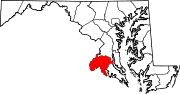
U.S. Highways Roads in Prince George's County, Maryland Maryland State Highways 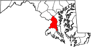
U.S. Routes Interstate Highways Roads by name Accokeek Road • Brandywine Road • Cherry Hill Road • Croom Road • Indian Head Highway • Oxon Hill Road • Piscataway Road • Saint Barnabas Road • Woodyard RoadCategories:- State highways in Maryland
- Roads in Charles County, Maryland
- Roads in Prince George's County, Maryland


Wikimedia Foundation. 2010.