- Massacre Canyon
-
Massacre Canyon Battlefield
 View looking southwest from the Massacre Canyon monument
Nearest city: Trenton, Nebraska Area: 3,680 acres (1,490 ha) Built: 1873 Governing body: Private NRHP Reference#: 74001118[1] Added to NRHP: July 25, 1974 The Massacre Canyon Battle took place on August 5, 1873, in Hitchcock County, Nebraska, it was one of the last battles between the Pawnee and the Sioux and the last large scale battle between Native American tribes in the area of the present day United States of America.[2] The battle occurred when a combined Oglala, and Brulé Sioux war party of over a thousand braves attacked a party of Pawnee on their summer buffalo hunt. According to Indian agent John W. Williamson who accompanied the hunting party; On the 2d day of July, 1873, the Indians, to the number of 700, left Genoa for the hunting grounds. Of this number 350 were men, the balance women and children.
The Pawnee were traveling along the west bank of the canyon through which flowed a creek which fed into the Republican River when they were attacked. Sixty-nine Pawnee were killed, and this massacre was one of the mediating factors which led to their decision to move to a reservation in Indian Territory in what is today Oklahoma.[3] Principal chiefs at the battle were:
- Pawnee: Sky Chief, Sun Chief, Fighting Bear, Ruling His Son.
- Sioux: Spotted Tail (Brulé chief), Little Wound (Oglala chief), Two Strike (Brulé chief). Chief Charging Bear (John Grass, Santee, Dakota).
Among the Pawnee dead were the wife and four children of Traveling Bear, a former sergeant in the Pawnee scouts who served under Major Frank North, and a Medal of Honor recipient.[4]
Contents
Agent Williamsons Account
John Williamson (23), was assigned as the Pawnee agent at the Genoa Agency, the Pawnnee reservation, and accompanied the Pawnee on their hunt.
On the fourth day of August we reached the north bank of the Republican River and went into camp. At 9 o'clock that evening, three white men came into camp and reported to me that a large band of Sioux warriors were camped twenty-five miles [40 km] northwest, waiting for an opportunity to attack the Pawnees for several days, anticipating that we that we would move up the river where buffaloes were feeding. Previous to this, white men visited us and warned us to be on our guard against Sioux attacks, and I was a trifle skeptical as to the truth of the story told by our white visitors. But one of the men, a young man about my age at the time, appeared to be so sincere in his efforts to impress upon me that the warning should be heeded, that I took him to Sky Chief who was in command that day, for a conference. Sky Chief said the men were liars; that they wanted to scare the Pawnees away from the hunting grounds so that white men could kill buffaloes for hides. He told me I was squaw and a coward. I took exception to his remarks, and retorted: "I will go as far as you dare go. Don't forget that."
The following morning August 5, we broke camp and started north, up the divide between the Republican and the Frenchman Rivers. Soon after leaving camp, Sky Chief rode up to me and extending his hand said, "Shake, brother." He recalled our little unpleasantness the night previous and said he did not believe there was cause for alarm, and was so impressed with the belief that he had not taken the precaution to throw out scouts in the direction the Sioux were reported to be. A few minutes later a buffalo scout signaled that buffaloes had been sighted in the distance, and Sky Chief rode off to engage in the hunt. I never saw him again. He had killed a buffalo and was skinning it when the advance guard of the Sioux shot and wounded him. The Chief attempted to reach his horse, but before he was able to mount, several of the enemy surrounded him. He died fighting. A Pawnee, who was skinning a buffalo a short distance away, but managed to escape, told me how Sky Chief died.
Monument
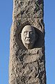
 Massacre Canyon monument
The Massacre Canyon Monument was dedicated on Sept. 26, 1930. It was the first historical monument erected in Nebraska by Federal grant. It stands on a three-acre (1.2 ha) plot, three miles (4.8 km) east of Trenton off U.S. Route 34, after having been moved from its original location overlooking the Republican River valley. The monument was constructed from Minnesota pink granite from a quarry in St. Cloud. The shaft of the obelisk is 35 feet (11 m) high. The base measures 9 feet (2.7 m) by 9.5 feet (2.9 m) across; the bottom of the shaft is five feet (1.5 m) across, tapering to 32 inches (81 cm) near the top. The entire monument weighs 91 tons (83,000 kg).
The monument is located in a small park area with picnic tables and a visitor center that features exhibits about early pioneers, the tribal customs of the Sioux and the Pawnee People and a gift shop.
Gallery
-
Ruling His Son
Pawnee Chief -

Ruling His Son
Pawnee chief -

Sky Chief
Pawnee -

Sun-Chief
Pawnee chief -

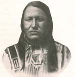
Chief John Grass
Dakota, Sioux -

Chief John Grass
Dakota, Sioux -

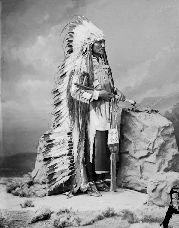
Chief Little Wound
Oglala Sioux -

Chief Two Strike
Brule Sioux
References
- ^ "National Register Information System". National Register of Historic Places. National Park Service. 2009-03-13. http://nrhp.focus.nps.gov/natreg/docs/All_Data.html.
- ^ The Nebraska Indian Wars reader, 1865-1877 By R. Eli Paul p.88 Publisher: University of Nebraska Press (April 1, 1998) Language: English ISBN 0-8032-8749-6
- ^ Massacre along the Medicine Road: a social history of the Indian War of 1864 p. 389 By Ronald Becher Publisher: Caxton Press (March 1, 1999) Language: English ISBN 0-87004-387-0
- ^ Medal of honor: historical facts & figures By Ron Owens p.52
Bibliiography
The Pawnee nation: an annotated research bibliography By Judith A. Boughter Publisher: The Scarecrow Press, Inc. (March 29, 2004) Language: English ISBN 0-8108-4990-9
External links
- Massacre Canyon Monument
- LAST BUFFALO HUNT OF THE PAWNEES By John W. Williamson
- "Massacre Canyon saga is just one story in a rich Native American history in Nebraska" - Nebraska Rural Living article
- Massacre Canyon Monument and Visitor Center - Visit Nebraska
Native Americans in Nebraska Tribes Reservations Former reservations Figures Antonine Barada · Big Elk · Chief Blackbird · Joba Chamberlain · Larry EchoHawk · Logan Fontenelle · Francis La Flesche · Joseph La Flesche · Old Lady Grieves The Enemy · Petalesharo · Susan La Flesche Picotte · Red Cloud · Standing Bear · Susette LaFlesche Tibbles · Jim Thorpe · James Young Deer · Moses J. "Chief" Yellow HorsePlaces Blackbird Hill · Nanza · Genoa Indian Industrial School · Ton'wontongathon · Pahur · Ahkawitakol · Lalawakohtito · Pahuk · Pike-Pawnee Village SiteLanguages Events Battle of Ash Hollow · Massacre Canyon · Battle of War Bonnet Creek · Grattan massacre · Cheyenne WarU.S. National Register of Historic Places Topics Lists by states Alabama • Alaska • Arizona • Arkansas • California • Colorado • Connecticut • Delaware • Florida • Georgia • Hawaii • Idaho • Illinois • Indiana • Iowa • Kansas • Kentucky • Louisiana • Maine • Maryland • Massachusetts • Michigan • Minnesota • Mississippi • Missouri • Montana • Nebraska • Nevada • New Hampshire • New Jersey • New Mexico • New York • North Carolina • North Dakota • Ohio • Oklahoma • Oregon • Pennsylvania • Rhode Island • South Carolina • South Dakota • Tennessee • Texas • Utah • Vermont • Virginia • Washington • West Virginia • Wisconsin • WyomingLists by territories Lists by associated states Other  Category:National Register of Historic Places •
  Portal:National Register of Historic PlacesCategories:
- Native American history of Nebraska
- History of Nebraska
- Lakota
- Pawnee
- National Register of Historic Places in Nebraska
- Geography of Hitchcock County, Nebraska
- Monuments and memorials in Nebraska
- Visitor attractions in Hitchcock County, Nebraska
- Buildings and structures in Hitchcock County, Nebraska


Wikimedia Foundation. 2010.