- Matua (island)
-
For other uses, see Matua (disambiguation).
Matua Native name: Матуа
松輪島

Geography Location Sea of Okhotsk Coordinates 48°06′N 153°12′E / 48.1°N 153.2°E Archipelago Kurile Islands Area 52 km2 (20.1 sq mi) Highest elevation 1,496 m (4,908 ft) Highest point Pik Sarychev Country RussiaDemographics Population 0 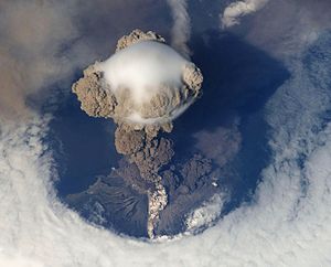 Eruption of Sarychev volcano
Matua (Russian: Матуа, Matsuwa Japanese: 松輪島; Matsuwa-tō) is an uninhabited volcanic island near the center of the Kuril Islands chain in the Sea of Okhotsk in the northwest Pacific Ocean, 16 kilometers across Golovnin Strait from Raikoke. Its name is derived from the Ainu language, from “hellmouth”.
Contents
Geology
Matua is roughly oval, with a length of 11 kilometres (6.8 mi) with a width of 6.5 kilometres (4.0 mi), and an area of 52 square kilometres (20 sq mi).[1] The island is a complex stratovolcano with two main peaks.
Sarychev Peak (Russian: влк.Сарычева , Japanese: 芙蓉山; Fuyōzan, also known as Matsuwa-Fuji) in the northwest of the island is one of the most active volcanoes of the Kuril Islands. The central cone has a 250 meter wide, very steep-walled crater with a jagged rim, rising to a height of 1,496 metres (4,908 ft). Lava flows descending on all sides of the peak forms capes along the coast. Eruptions have been recorded since the 1760s, including 1878–1879, 1923, 1930, 1946, 1960, 1976, 1981, 1987, 1989 and 2009, with the largest in 1946 which produced pyroclastic flows that reached the sea. The 2009 eruption was large enough to affect air traffic between Asia and North America.
The much smaller peak to the south, Japanese: 天蓋山; Tengaizan has a height of 127 metres (417 ft).
History
Matua was visited by hunting and fishing parties of the Ainu, but there was no permanent habitation at the time of European contact. The island appears on an official map showing the territories of Matsumae Domain, a feudal domain of Edo period Japan dated 1644, and these holdings were officially confirmed by the Tokugawa shogunate in 1715. Subsequently claimed by the Empire of Russia, sovereignty initially passed to Russia under the terms of the Treaty of Shimoda, but was returned to the Empire of Japan per the Treaty of Saint Petersburg (1875) along with the rest of the Kurile islands. The island was formerly administered as part of Shimushiru District of Nemuro Subprefecture of Hokkaidō.
During World War II the Imperial Japanese Army had an airfield located on this island. The island was garrisoned by 7000-8000 men of the 41st Independent Mixed Regiment, 6th Independent Tank Company, and supporting units. During 1944 the Japanese facilities on the island were intermittently bombed by the US Army Air Force or shelled by ships of the United States Navy. Several Japanese cargo vessels were sunk near the island, and while at harbor. On June 1, 1944, a Japanese shore battery on Point Tagan sank the American submarine USS Herring. During the Soviet Battle of the Kuril Islands after the end of World War II, the Japanese garrison surrendered without resistance.
After World War II, the island came under the control of the Soviet Union, and the former Japanese military facilities were manned by the Soviet Border Troops. Following the withdrawal of Soviet military forces following the dissolution of the Soviet Union in 1999, the island has been uninhabited. It is now administered as part of the Sakhalin Oblast of the Russian Federation.
See also
References
External links
- Matua Island at Oceandots
- Central Kurile Islands — Volcano World.
- Sarychev Peak
Further reading
- Gorshkov, G. S. Volcanism and the Upper Mantle Investigations in the Kurile Island Arc. Monographs in geoscience. New York: Plenum Press, 1970. ISBN 0-306-30407-4
- Krasheninnikov, Stepan Petrovich, and James Greive. The History of Kamtschatka and the Kurilski Islands, with the Countries Adjacent. Chicago: Quadrangle Books, 1963.
- Rees, David. The Soviet Seizure of the Kuriles. New York: Praeger, 1985. ISBN 0-03-002552-4
- Takahashi, Hideki, and Masahiro Ōhara. Biodiversity and Biogeography of the Kuril Islands and Sakhalin. Bulletin of the Hokkaido University Museum, no. 2-. Sapporo, Japan: Hokkaido University Museum, 2004.
Notes
- ^ "International Kuril Island Project(IKIP)". University of Washington Fish Collection or the respective authors. http://www.washington.edu/burkemuseum/collections/ichthyology/okhotskia/ikip/Info/physical.html.

 Islands of the Sea of OkhotskAntsiferov · Arka · Atlasov · Banka Zotova · Baydukov Island · Belyakov Island · Bolshoy Chome · Bolshoy Shantar · Brat Chirpoyev · Broutona · Chastye Islands · Chetyre Paltsa · Chirinkotan · Chirpoy · Chkalov Island · Dobrzhansky Island · Ekarma · Feklistova · Hokkaidō · Iony Island · Iturup · Kamen-Mukdykyn · Kamen Opasnosti · Kekurniy Island · Ketoy · Khalpili Islands · Kharimkotan · Konus · Krayniy Island · Kunashir · Kuril Islands · Makanrushi · Matua · Menshikov Island · Morskaya Matuga · Nansikan Island · Nedorazumeniya · Onekotan · Oremif · Paramushir · Pilamif · Raikoke · Rasshua · Rechnaya Matuga · Reyneke Island · Rovnyy · Sakhalin · Shantar Islands · Shelikan · Shiashkotan · Shumshu · Simushir · Spafaryev Islands · Talan Island · Telan Island · Tretiy Island · Tyuleniy Island · Umara · Urup · Ush · Ushishir · Vtoroy · Yam Islands · Yengalychev Island · Zavyalov · ZubchatyCategories:
- Stratovolcanoes
- Active volcanoes
- Kuril Islands
- Uninhabited islands of Russia
- Matua (island)


Wikimedia Foundation. 2010.