- Mavesyn Ridware
-
Coordinates: 52°45′00″N 1°52′56″W / 52.749992°N 1.882105°W
Mavesyn Ridware 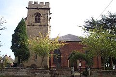
St Nicholas Church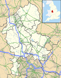
 Mavesyn Ridware
Mavesyn Ridware shown within StaffordshireOS grid reference SK082169 Parish Mavesyn Ridware District Lichfield Shire county Staffordshire Region West Midlands Country England Sovereign state United Kingdom Post town RUGELEY Postcode district WS15 Dialling code 01543 Police Staffordshire Fire Staffordshire Ambulance West Midlands EU Parliament West Midlands UK Parliament Lichfield List of places: UK • England • Staffordshire Mavesyn Ridware is a small village and civil parish[1] in Lichfield District, Staffordshire, England. The parish also includes the villages of Hill Ridware, Rake End, Pipe Ridware and Blithbury, all of which lie between the River Trent and a small tributary, the River Blithe. Adjacent to the east is the parish of Hamstall Ridware; to the south is the much larger village of Armitage.
Mavesyn Ridware contains two notable buildings: the parish church dedicated to St Nicholas and the Gatehouse of the former ancient Manor House. "Mavesyn" is derived from the French Malvoisin which was the name of the Norman family who acquired the local estate following the Norman conquest of 1066. The Church contains many monuments to members of this family and to their successors the Cawardens and the Chadwicks. The gatehouse is timber framed with a later brick and stone skin. Dendrochronology on the timber indicates that the building was erected in 1391/2.
References
- ^ "Names and codes for Administrative Geography". Office for National Statistics. 31 December 2008. http://www.ons.gov.uk/about-statistics/geography/products/geog-products-area/names-codes/administrative/index.html. Retrieved 15 September 2009.
External links
 Media related to Mavesyn Ridware at Wikimedia Commons
Lichfield District Council Lichfield District CouncilCivil parishes Alrewas • Armitage with Handsacre • Burntwood • Clifton Campville • Colton • Curborough and Elmhurst • Drayton Bassett • Edingale • Elford • Farewell and Chorley • Fazeley • Fisherwick • Fradley • Hammerwich • Hamstall Ridware • Harlaston • Hints • Kings Bromley • Lichfield • Longdon • Mavesyn Ridware • Shenstone • Streethay • Swinfen and Packington • Thorpe Constantine • Wall • Weeford • Whittington • Wigginton and HopwasCategories:- Lichfield
- Villages in Staffordshire
- Civil parishes in Staffordshire


Wikimedia Foundation. 2010.