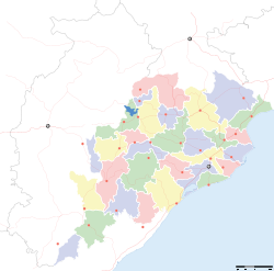
- Mayurbhanj district
-
Mayurbhanj — district — Coordinates 21°55′59″N 86°43′59″E / 21.933°N 86.733°ECoordinates: 21°55′59″N 86°43′59″E / 21.933°N 86.733°E Country India State Orissa Headquarters Baripada Collector Smt. Aswathy S., IAS Member of Parliament Laxman Tudu, BJD Parliamentary constituency 1, Mayurbhanj Assembly constituency 10 Population
• Density
2,223,456 (2001[update])
• 658 /km2 (1,704 /sq mi)
Sex ratio 1.020 ♂/♀ Literacy
• Male
• Female52.43%
• 66.38%
• 38.28%Official languages Oriya, Hindi, English Time zone IST (UTC+05:30) Area
10,418 square kilometres (4,022 sq mi)
• 559.31 metres (1,835.0 ft)
Climate
Aw (Köppen)
• 1,648.2 mm (64.89 in)
Distance(s)-
• From • 253 kilometres (157 mi) SSW (land)
Codes-
• Pincode • 757 xxx • Vehicle • OR-11
Website mayurbhanj.nic.in Mayurbhanj district is one of the 30 districts in Orissa state in eastern India. It is the largest district of Orissa by area. Baripada city is the district headquarters. As of 2011 it is the third most populous district of Orissa (out of 30), after Ganjam and Cuttack.[1]
Contents
History
Mayurbhanj District was formed out of erstwhile Princely State of Mayurbhanj. It is currently a part of the Red Corridor.[2]
Geography
Towns
Economy
In 2006 the Ministry of Panchayati Raj named Ranchi one of the country's 250 most backward districts (out of a total of 640).[3] It is one of the 19 districts in Orissa currently receiving funds from the Backward Regions Grant Fund Programme (BRGF).[3]
Demographics
According to the 2011 census Mayurbhanj district has a population of 2,513,895 ,[4] roughly equal to the nation of Kuwait[5] or the US state of Nevada.[6] This gives it a ranking of 171st in India (out of a total of 640).[4] The district has a population density of 241 inhabitants per square kilometre (620 /sq mi) .[4] Its population growth rate over the decade 2001-2011 was 13.06%.[4] Mayurbhanj has a sex ratio of 1005 females for every 1000 males,[4] and a literacy rate of 63.98%.[4]
Culture
Tourism
Mayurbhanj has many tourist destinations. The Shimilipal is an internationally renowned tiger and forest reserve. It became source of international attention in 1960s when the then director of the tiger reserve had adopted a tigress known as Khairi. Mayurbhanj, as a Princely State, was a most progressive one during British rule. The Kings of Mayurbhanj were pioneers in the upliftment of Orissa under British rule . Today Mayurbhanj is the largest district in size in Orissa . It is coming up with higher educational institutions and technical colleges.
Cuisine
Mudhi (puffed rice) is the popular diet here.
Notable people
- Jatin Das, International painter[citation needed]
- Nandita Das, International actress[citation needed]
- Bijay Mohanty, actor in Oriya-language films
- Uttam Mohanty, actor in Oriya-language films[citation needed]
- Jogesh Pati, an Indian American theoretical physicist at the University of Maryland, USA
Flora and fauna
A national park for tigers and other wildlife, known as Simlipal National Park, is situated in Mayurbhanj district.
References
- ^ "District Census 2011". Census2011.co.in. 2011. http://www.census2011.co.in/district.php. Retrieved 2011-09-30.
- ^ "83 districts under the Security Related Expenditure Scheme". IntelliBriefs. 2009-12-11. http://intellibriefs.blogspot.com/2009/12/naxal-menace-83-districts-under.html. Retrieved 2011-09-17.
- ^ a b Ministry of Panchayati Raj (September 8, 2009). "A Note on the Backward Regions Grant Fund Programme". National Institute of Rural Development. http://www.nird.org.in/brgf/doc/brgf_BackgroundNote.pdf. Retrieved September 27, 2011.
- ^ a b c d e f "District Census 2011". Census2011.co.in. 2011. http://www.census2011.co.in/district.php. Retrieved 2011-09-30.
- ^ US Directorate of Intelligence. "Country Comparison:Population". https://www.cia.gov/library/publications/the-world-factbook/rankorder/2119rank.html. Retrieved 2011-10-01. "Kuwait 2,595,62"
- ^ "2010 Resident Population Data". U. S. Census Bureau. http://2010.census.gov/2010census/data/apportionment-pop-text.php. Retrieved 2011-09-30. "Nevada 2,700,551"
External links

Paschim Singhbhum district, Jharkhand Seraikela Kharsawan district, Jharkhand Purbi Singhbhum district, Jharkhand 

Paschim Medinipur district, West Bengal  Mayurbhanj district

Kendujhar district Baleshwar district State of Orissa · 
Capital 
Topics Districts Angul · Balasore · Bargarh · Bhadrak · Balangir · Boudh · Cuttack · Debagarh · Dhenkanal · Gajapati · Ganjam · Jagatsinghpur · Jajpur · Jharsuguda · Kalahandi · Kandhamal · Kendrapara · Kendujhar · Khordha · Koraput · Malkangiri · Mayurbhanj · Nabarangpur · Nayagarh · Nuapada · Puri · Rayagada · Sambalpur · Subarnapur · Sundargarh
Cities Orissa Portal Cities and towns in Mayurbhanj Mayurbhanj Baripada · Karanjia · Rairangpur · Udala
Cities and towns
in other districtsAngul · Balangir · Balasore · Bargarh · Bhadrak · Boudh · Cuttack · Debagarh · Dhenkanal · Gajapati · Ganjam · Jagatsinghpur · Jajpur · Jharsuguda · Kalahandi · Kandhamal · Kendrapara · Kendujhar · Khordha · Koraput · Malkangiri · Nabarangpur · Nayagarh · Nuapada · Puri · Rayagada · Sambalpur · Subarnapur · Sundergarh
Districts of Orissa Angul · Balangir · Balasore · Bargarh · Bhadrak · Boudh · Cuttack · Debagarh · Dhenkanal · Gajapati · Ganjam · Jagatsinghpur · Jajpur · Jharsuguda · Kalahandi · Kandhamal · Kendrapara · Kendujhar · Khordha · Koraput · Malkangiri · Mayurbhanj · Nabarangpur · Nayagarh · Nuapada · Puri · Rayagada · Sambalpur · Subarnapur · SundergarhMahanadi-Brahmani-Baitarani Basin Rivers Dams, barrages Geographical features Dandakaranya • Dakshina Kosala Kingdom • Chota Nagpur Plateau • Western Orissa • Mahanadi River Delta • Bhitarkanika MangrovesRiparian districts Chhattisgarh Dhamtari • Kanker • Raipur • Janjgir-Champa • Raigarh • Jashpur • Korba • Koriya • Surguja Madhya Pradesh Anuppur Jharkhand Gumla • Khunti • Ranchi • West Singhbhum Orissa Jharsuguda • Kendujhar • Mayurbhanj • Sundergarh • Boudh • Angul • Jajpur • Cuttack • Kendrapara • Khordha • Jagatsinghpur • PuriLanguages/ people Coalfields Industries Korba Super Thermal Power PlantTransport Related topics Hydrology of Chhattisgarh • Hydrology of Jharkhand • Hydrology of OrissaCategories:- Mayurbhanj district
- Orissa geography stubs
-
Wikimedia Foundation. 2010.


