- Mazandaran Province
-
This article is about Māzandarān Province of Iran . For Historic Tabarestan region, see Tabaristan.
Mâzandaran Province
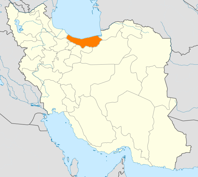
استان مازندران— Province —  Location of Mâzandarân within Iran
Coordinates: 36°33′56″N 53°03′32″E / 36.5656°N 53.0588°ECoordinates: 36°33′56″N 53°03′32″E / 36.5656°N 53.0588°E Country  Iran
IranCapital Sari Counties 16 Area - Total 23,842 km2 (9,205.4 sq mi) Population (2010)[1][2] - Total 2,922,432 - Density 122.6/km2 (317.5/sq mi) Time zone IRST (UTC+03:30) - Summer (DST) IRST (UTC+04:30) Main language(s) Mazandarani(Tabari)[3]
Persian[3]Mazandaran Province (Persian: استان مازندران, Ostān-e Māzandarān ) [4] is a Caspian province in the north of Iran.[5] Located on the southern coast of the Caspian Sea, it is bordered clockwise by the Golestan, Semnan, Tehran, Alborz, Qazvin, and Gilan provinces.
Mazandaran is one of the most densely populated provinces in Iran[6] and has diverse natural resources, especially large reservoirs of oil and natural gas.[7] The province's five largest counties are Sari, Behshahr, Babol, Amol and Qaemshahr.[1] Founded as province in 1937, Mazandaran was declared the second modern province after neighbouring Gilan.
The diverse nature of the province features plains, prairies, forests and rainforest [8] stretching from the sandy beaches of the Caspian Sea to the rugged and snowcapped Alborz sierra,[9] including Mount Damavand, the highest peak and volcano in the Middle East and Western Asia,[10] which at the narrowest point (Nowshahr County) narrows to 5 miles.
Mazandaran is a major producer of farmed fish,[11] and aquaculture provides an important economic addition to traditional dominance of agriculture.[12] Another important contributor to the economy is the tourism industry, as people from all of Iran enjoy visiting the area.[13] Mazandaran is also a fast-growing centre for biotechnology[7] and civil engineering.
Human habitation in the area dates back at least 75,000 years.[14][15] Recent excavations in Goher Tippe provide proof that the area has been urbanized for more than 5,000 years, and the area is considered one of the most important historical sites of Iran.[16] It has played an important role in cultural and urban development of the region.[17]
Indigenous peoples of the region include the ethnic Mazanderanis[18] speaking an Iranian language which most resembles Gilaki and Sangiseri.[citation needed]
Contents
History
-
- See Also:History of Tapuria
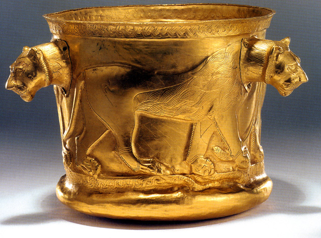
 The Hyrcanian Golden Cup. Dated first half of first millennium. Excavated at Kalardasht in Mazandaran.
Pre Islamic history
The region is known to have been populated from early antiquity, and Mazandaran has changed hands among various dynasties from early in its history. There are several fortresses remaining from Parthian and Sassanid times, and many older cemeteries scattered throughout the province. During this era, Mazandaran was part of Hyrcania Province which was one of important provinces.
With the advent of the Sassanid dynasty, the King of Mazandaran (Tabaristan and Padashkhwargar) was Gushnasp,[19] whose ancestors had reigned in the area (under the Parthian empire) since the time of Alexander. In 529-536, Mazandarn was ruled by the Sassanid prince Kawus, son of Kawadh.[19] Anushirawan, the Sassanid king, defeated Zarmihr, who claimed his ancestry from the legendary blacksmith Kaveh.[19] This dynasty ruled till 645 A.D., when Gil Gilanshah (a descendant of the Sassanid king Jamasp and a son of Piruz) joined Mazandaran to Gilan.[19] These families had descendants who ruled during the Islamic period.
Post Islamic history
 Mazandaran was among the last parts of Persia standing against Muslim conquests
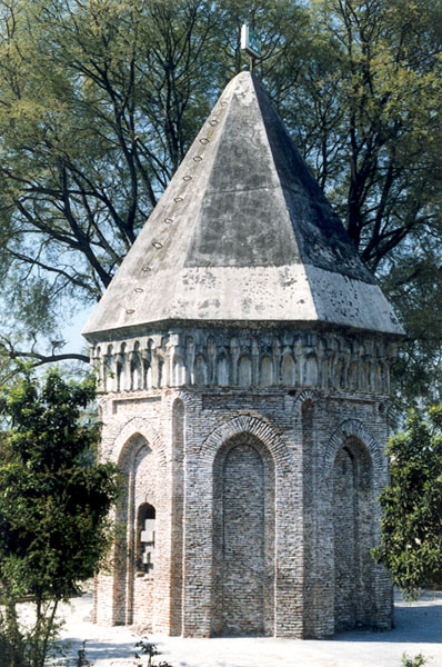
 Mir Heydar Amoli (Seyyed Se Tan) shrine in Amol, 15th century
 Map of the Mazandaran Alavid emirate (864-929 AD)
During the post-Islamic period the local dynasties fall into three classes: 1. local families of pre-Islamic origin, 2. the ʿAlid sayyid s, and 3. local families of secondary importance.[19]
The Bawandids who claimed descent from Kawus provided three dynasties.[19] The first dynasty (665-1007) was overthrown on the conquest of Tabaristan by the Ziyarid Kabus b. Wushmgir.[19] The second dynasty reigned from 466/1073 to 606/1210 when Mazandaran was conquered by 'Ala al-Din Muhammad Khwarzamshah.[19] The third ruled from 635/1237 to 750/1349 as vassals of the Mongols.[19] The last representative of the Bawandids was killed by Afrasiyab Chulawi.[19]
The Karinids claimed descent from Karin, brother of Zarmihr who was the pre-Islamic ruler under the Sassanids.[19] Their last representative Mazyar was put to death in 224/839.[19]
The Paduspanids claimed descent from the Dabyuids of Gilan.[19] They came to the front about 40/660 and during the rule of the ʿAlids were their vassals. Later, they were vassals of the Buyids and Bawandids, who deposed them in 586/1190.[19] The dynasty, restored in 606/1209-10, survived till the time of Timur; the branch descended from Kawus the son of Kayumarth reigned till 975/1567 and the other, that of Iskandar the son of Kayumarth, till 984/1574.[19]
In 662 CE, ten years after the death of Yazdegerd III the last Sassanian Emperor, a large Muslim army under the command of Hassan ibn Ali (Imam Hassan, the second Sunni's/Shi'a Imam) invaded Tabarestan (Mazandaran as it was then called)[citation needed] only to be severely beaten, suffering heavy losses to the forces of the Zoroastrian princes of the Dabboyid house. For the next two hundred years, Tabaristan maintained an existence independent of the Umayyad Caliphate which supplanted the Persian Empire in the early seventh century, with independent Zoroastrian houses like the Bavand and Karen fighting an effective guerilla warfare against Islam. A short-lived Alid Shiite state collapsed before the subsequent take-over by the Ziyarid princes. Mazandaran, unlike much of the rest of the Iranian Plateau maintained a Zoroastrian majority until the 12th century, thanks to its isolation and hardy population which fought against the Caliph's armies for centuries.
During the Abbasid caliphate of Abou Jafar Al-Mansur, Tabaristan witnessed a wave of popular revolt. Ultimately, Vandad Hormoz established an independent dynasty in Tabaristan in 783[citation needed]. In 1034, Soltan Mahmoud Ghaznavi entered Tabarestan via Gorgan followed by the invasion of Soltan Mohammad Kharazmshah in 1209. Thereafter, the Mongols governed the region until they were overthrown by the Timurid Dynasty. After the dissolution of the feudal government of Tabaristan, Mazandaran was incorporated into modern Persian Empire by Shah Abbas I in 1596. In the Safavid era Mazandaran was settled by Georgian migrants, whose descendants still live across Mazandaran. Towns, villages and neighbourhoods in Mazandaran still bear the name "Gorji" (i.e. Georgian) in them, although most of the Georgians are already assimilated into the mainstream Mazandaranis. The history of Georgian settlement is described by Eskandar Beyg Monshi, the author of the 17th century Tarikh-e Alam-Ara-ye Abbasi, among other authors.
Before the reign of Nadir Shah, the province was briefly occupied by the Russian army in the aftermath of the Russo-Persian War, 1722-1723 and returned to Persia in 1735.
Geography and population
Geography
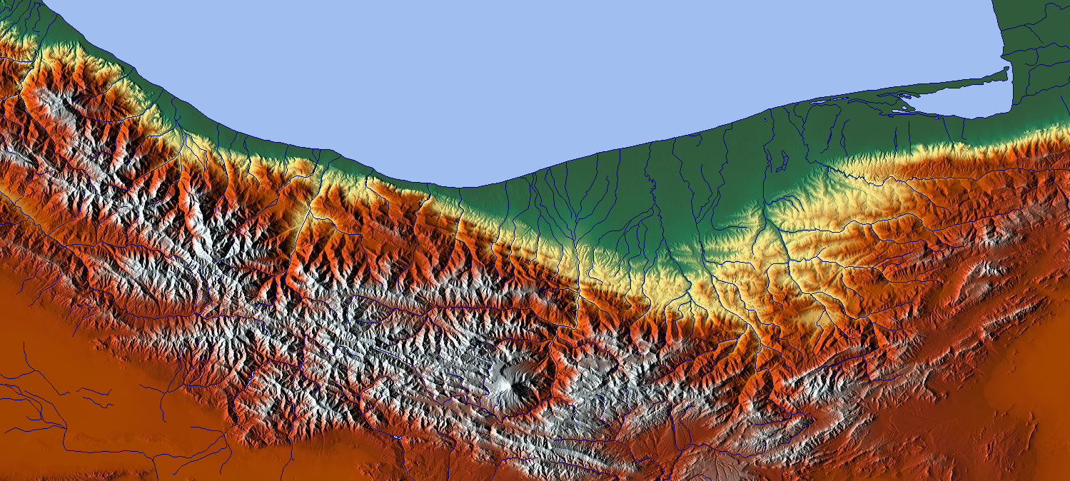
 Relief map of Mazandaran area
 View of the Caspian coast from the Namak Abrood tourist resort.
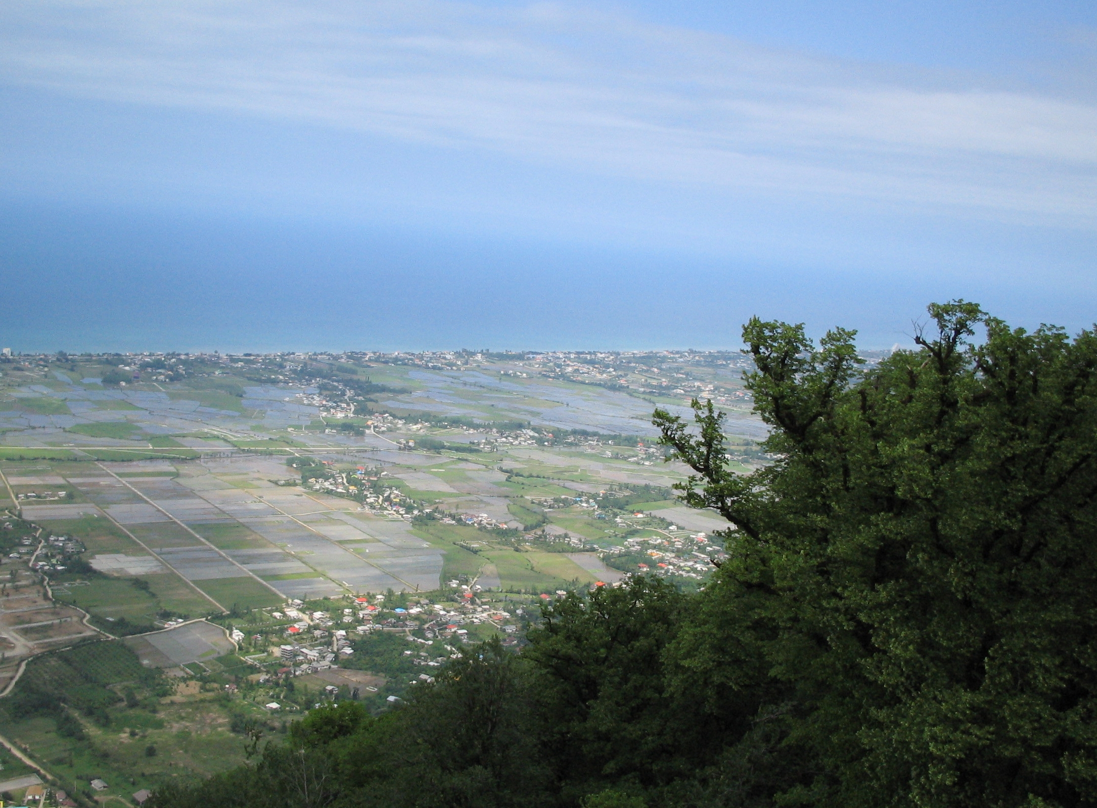
Mazandaran is located on the southern coast of the Caspian Sea. It is bordered clockwise by Golestan, Semnan and Tehran provinces.[20] This province also borders Qazvin and Gilan to the west. Mazandaran province is geographically divided into two parts: the coastal plains, and the mountainous areas. The Alborz Mountain Range surrounds the coastal strip and plains of the Caspian Sea.
There is often snowfall in the Alborz regions, which run parallel to the Caspian Sea's southern coast, dividing the province into many isolated valleys. The province enjoys a moderate, subtropical climate with an average temperature of 25 °C in summer and about 8 °C in winter. Although snow may fall heavily in the mountains in winter, it rarely falls at sea level.
Ecoregions:
Population
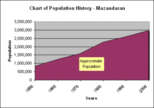
The population of the province has been steadily growing during the last 50 years. The following table shows the approximate province population, excluding the Golestan province, which has separated as an independent province in 1998 [5].
The population is of Caucasian Iranian stock with a minority of non-native neighboring Turkic tribes (esp. the Turkomen).
Year 1956 1966 1976 1986 1996 2006 2008 Approximate population 835,000 1,250,000 1,596,000 2,275,000 2,602,000 2,922,000 3,090,000 Administrative divisions
The province covers an area of 23,842 km²[6]. According to the census of 2006, the population of the province was 2,922,432 of which 53.18% were registered as urban dwellers, 46.82% villagers, and remaining were non-residents. Sari is the capital city of the province.
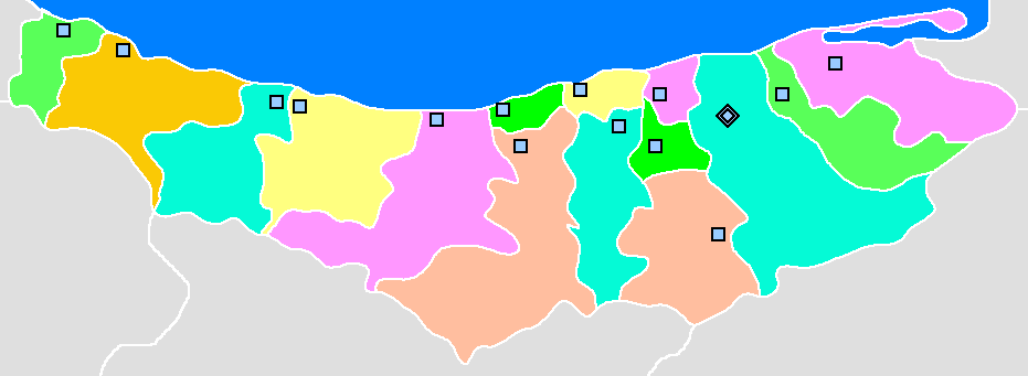
Mazandaran is divided into 15 counties (shahrestan in Persian). All the shahrestans are named after their administrative center, except Savadkooh. The following map shows the respective positions of the counties.
 Mahmood AbadJooybarSavadkoohSary
Transportation
 Main transport routes in Mazandaran (Click to see a larger version)
Gorgan 

Sabzdasht 
Bandar Torkaman 
Bandar Gaz Galoogah Tirtash Behshahr Rostamkola 

Amir Abad Neka Nobakht Sari Gooni Bafi Qaemshahr Shirgah Zirab Pol Sefid Savadkooh Sorkh Abad Veresk Dogol Gadook Firoozkooh Mahabad Zarrin Dasht Simin Dasht Kabootar Darreh Bonekooh 
To Tehran Dept.  1978 Iranian stamps showing traditional dressing of people of Mazandaran
Roads
Mazandaran is connected to the capital of Iran, Tehran, through three transit roads: Haraz road (Amol-Rudehen), Kandovan road (Chalus-Karaj), and Firoozkooh road (Qaem Shahr-Rudehen).
Airports
Dasht-e Naz Airport, serving the capital Sari, Noshahr Airport, and Ramsar Airport are the domestic airports that connect the province to the other parts of the country. There are some Hajj flights from Dasht-e Naz Airport as well.
Railway
Mazandaran is served by the North Railway Dept. of the Iranian Railways. The department connects the province to Tehran to the south and Gorgan to the east. The cities of Sari, Qaemshahr, and Pol Sefid are major stations of the department.
Culture
The culture of Mazandaran is closely related to that of neighboring Gilan (or Guilan). The peoples of the two provinces are largely secular, and consequently women have had greater social freedom and independence than their Persian cousins. (Reference: "The Soviet Socialist Republic of Iran, 1920-1921: Birth of the Trauma" by Cosroe Chaqueri.)
The cuisine of the province is very rich in seafood due to its location by the Caspian Sea, and rice is present in virtually every meal. Indeed, the rest of Iran was introduced to rice through Gilan and Mazandaran. Before the 1800s, Persians, Kurds, and other Iranian ethnic groups used bread rather than rice as an accompaniment to their meals, though bread remains a prominent staple among them. While bread remains very popular among those groups, in Gilan and Mazandaran, rice remains the choice staple of the indigenous inhabitants.
Language
Main article: Mazandarani LanguageMazanderani or Tabarian is a Northwestern Iranian language. Various Mazandarani dialects exist which are spoken in Mazandaran province and the neighbor province Golestan such as Mazanderani, and Gorgani and possibly Qadikolahi (Ghadikolahi) and Palani. Today, Mazandaranis also use Persian (Western Persian). The educated can communicate and read Persian well.[21]
A dialect of Azeri is spoken in the town of Galoogah.[22]
In literature
In the Persian epic, Shahnameh, Mazandaran is mentioned in two different sections. The first mention is implicit, when Fereydun sets its capital in a city called Tamishe near Amol:
بیاراست گیتی بسان بهشت.................... به جای گیا سرو گلبن بکشت
از آمل گذر سوی تمیشه کرد .............. نشست اندر آن نامور بیشه کرد
under the title "فریدون چو شد بر جهان کامگار", and when Manuchehr is returning to Fereydun's capital, Tamisheh in Mazandaran (known as Tabarestan), after his victory over Salm and Tur:[23]
ز دريای گيلان چون ابر سياه.............. دمادم به ساری رسيد آن سپاه
چو آمد بنزدیک شاه آن سپاه.................. فریدون پذیره بیامد براه
under the title "تهی شد ز کینه سر کینه دار".
In the second section, a region called Mazandaran is mentioned in the Kai Kavoos era; it is an area which is mostly inhabited by Div (demons). The legendary Iranian Shah Kaykavoos, as well as the Iranian hero Rostam, each take turn to go to Mazandaran in order to battle the demons.
A famous verse from Shahnameh is when Zal tells Kai Kavoos:
شنیدم یکی نو سخن بس گران ..........که شه دارد آهنگ مازندران
"I heard troubling news that the king is planning to go to Mazandaran"
 Temperate rainforest on the northern slopes of the Alborz mountain ranges
 Forest in Mazandaran
However, this Mazandaran is not considered identical to the modern province of Mazandaran, and is instead a land to the west of Iran. The current province was simply considered a part of Tabaristan; the name Mazandaran is a later development, perhaps based upon local terminology.[24]
Significant natives of Mazandaran
Mazandaran has been home to many significant Iranian figures. These range from scholars and poets to politicians and actors. Perhaps the most notable Mazandaranian figure is Reza Shah Pahlavi who was born in Alasht, Savad Kooh, Mazandaran in 1877. Reza Pahlavi became the Iranian Shah from 1925 until 1941, when he was forced to relinquish his throne to his son.
Notable Mazandaranian poets include the modernist poet Nima Yooshij, the great late contemporary poet of Iran who was born in Yush, Mazandaran.
Another famous contemporary poet is Mina Assadi, a Mazandarani native, born and raised in Sari, who is known for writing about controversial and provocative subjects.
Mírzá `Abbás Núrí, father of Mirzá Husayan-Alí Núrí, known as Bahá'u'lláh, founder of the Bahá'í Faith, is a native of Núr (Noor) in Mazandaran.
Mazandaran today
Economy
 Abbas Abad lake, near Behshahr.
Rice, grain, fruits, cotton, tea, tobacco, sugarcane, and silk are produced in the lowland strip along the Caspian shore. Oil wealth has stimulated industries in food processing, cement, textiles, cotton, and fishing (caviar).
 The resort of National Iranian Oil Company, near Mahmoodabad.
The province's pleasant and moderate climate, beautiful natural landscapes, and proximity to Tehran, have led the province to be one of the main recreational and tourism areas of Iran.
Iran's Cultural Heritage Organization lists close to 630 sites of historical and cultural significance, hence a wealth of tourist attractions.
Colleges and universities
- Babol Noshirvani University of Technology
- Babol University of Medical Sciences
- Mazandaran University of Medical Sciences
- University of Mazandaran
- Behshahr University of Science and Technology
- Islamic Azad University of Mazanderan (Sari, Behshahr, Ghaemshahr, Babol, Amol, Chalus, Shahsawar, Neka)
- Imam Khomeini University for Naval Sciences
- Shomal University Amol
- M.I.T. located in Babol (Mazanderan Institute of Technology)
- Babol Tabari University
- Babol Olum-Fonun University
- Babol Imam Sadegh University
- Tabarestan University in Chaloos (Tabarestan University's Website)
Mazandaran Branches of Applied Science UniversityOtherNon-governmental UniversitiesTabarestan • Hadaf • Maziar • shomal university • Khazar • Allame Mohaddes Noori • Amol • Adibe Mazandaran • Roozbahan • Sarian • Tabari • Parsa • Kamalol Molk • Aryan (Iranika) • MarlikBande pey • Amol • Rine • Babol • Behshahr • Kalle Bast • Behnamir • Sari • Ramsar • Jooybar • Tonekabon • GhaemShahr • Zirab • Pol Sefid • Nowshahr • Chamestan • Neka • Mahmood AbadSee also
- Mazandarani people
- Maziar
References
- ^ a b [1] National Census 2006
- ^ [2]
- ^ a b Maryam Borjian - Bilingualism in Mazandaran: Peaceful Coexistence With Persian.
- ^ Based on Maz or Mazan Term: Mazandarani: مازرون Māzerūn, Persian: مازندران, Russian: Мазендеран.
Based on Tapur Term: English: Tapuria, Arabic: Tabaristan, from Persian: Taparistan
Mazandarani:Tapurana.(not prevalent)
Ancient Greek: Hyrcania came from local name Vergana (Persian Gorgan), Caspia from local name Kaspi, See Caspian Sea.
Firdawsi called the Caspian region Gilan, so people refer to Caspian provinces as Gilan.
Note: It was also known as Al-Jannat by the Arabs, meaning paradise, during the 7–8th centuries. In the early 20th century, Reza Shah connected northern Elbourz to the southern slopes by constructing 7 new roads and railways, the provinces of Mazandaran and Gilan became known as Shomal by the Persians (meaning the North in Arabic). - ^ Keddie, N. R.; 1968; The Iranian villages before and after land reform. Journal of Contemporary History, 3(3), 69–78.
- ^ Statistical Centre, Government of Iran. See: "General Characteristics of Ostans according to their administrative divisions at the end of 1383 (2005 CE)", "Population estimation by urban and rural areas, 2005"
- ^ a b University of Mazanderan
- ^ Springer Netherlands; July 10, 2005; Contributions to the knowledge of the useful plants and plant raw materials of Iran; ISSN 0921-9668
- ^ Mazandaran, Geography & History
- ^ Encyclopedia Britannica, Entry for Elburz
- ^ Freshwater Fishes of Iran; Revised: 12 July 2007
- ^ Encyclopedia Britannica, Entry for Mazandaran
- ^ [3] (Persian)
- ^ Mazandaran setting up Iran's first cave museum; London; Saturday, July 22, 2006 by IranMania
- ^ IRAN Daily Caspian Region
- ^ Parthia News, November 6, 2005.
- ^ Payvand, 400 Historical Sites Discovered within 7 Days in Mazandaran
- ^ CHN Page for Mazandaran
- ^ a b c d e f g h i j k l m n o Minorsky, V.; Vasmer, R. "Mazandaran" Encyclopaedia of Islam. Edited by: P. Bearman , Th. Bianquis , C.E. Bosworth , E. van Donzel and W.P. Heinrichs. Brill, 2007. Brill Online.
- ^ Gwillim Law, Statoids website. "Provinces of Iran". Retrieved on 2007-08-28. ; See Also: Provinces of Iran
- ^ Gordon, R.G., Jr. (2005). Ethnologue: Languages of the World, 15th edition. (Dallas, TX: SIL International). Online version http://www.ethnologue.com
- ^ Lars Johanson, Éva Csató, Eva Agnes Csato. The Turkic Languages. Taylor & Francis, 1998. ISBN 0-415-08200-5; p. 274
- ^ Shahnameh/Book of Kings by Abu'L Ferdawsi, edited by Dr. jalal Khaleghi-Motlagh [4]
- ^ Iran Chamber Society: Geography of Iran: Ancient Iran’s Geographical Position in Shah-Nameh
External links
- Official website of Mazandaran Governorship
- ICCIM's page on Mazandaran
- Mazandaran Cultural Heritage Organization
- Mazandaran Tourism palaces
- Official website of Mazandaran Meteorology Organization
- A Mazandarani folk-song sung by Shusha Guppy in the 1970s: Darling Dareyne.

Gilan Province Caspian Sea Golestan Province Qazvin Province 
 Mazandaran Province

Alborz Province Tehran Province Semnan Province  Mazandaran Province
Capital 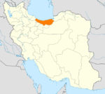
Counties and Cities Fereydunkenar CountyFereydunkenarGalugah CountyGalugahJuybar · Kuhi KheylMahmudabad · SorkhrudSurakQaem Shahr CountyQaem Shahr · KiakolaRamsar · Ketalem and Sadat ShahrSights Aab pari · Alasht · Babolsar · Badab-e Surt natural site · Dasht-e Naz national Park Sari · Larijan spa · Ghermerez spa · Qa'em Shahr's Imamzadeh kati · Sisangan national Park, Nowshahr · Challdareh national Park, Tonekabon · Veresk Bridge · Mohammad Hassan Khan Qajar's Bridge · Namakabrood's aerial tramway · Javaherdeh · Nima Yooshij's house in Yoush · Khestpol Bridge in Qa'em Shahr · Valasht lake, Kelardasht · Saadatmahaleh, Sari · Avidar lake Nowshahr · Lar Dam · Alam-Kuh · Palaeolithic caves of Kamarband’, and Hotu , Sari · Waterfall and Malekbahman castle of Shahandasht · Galehgardan, Tonekabon · Palace of Ramsar · Safavid gardens of Behshahr · Babol museum · Khoshedaran Museum of natural history, Fereydoon Kenar · Kandelus museum,near Chaloos · Sari's clock square · Rahband · Ramsar's old hotel ·Provinces of Iran Alborz · Ardabil · Bushehr · Chaharmahal and Bakhtiari · East Azerbaijan · Isfahan · Fars · Gilan · Golestan · Hamadan · Hormozgan · Ilam · Kerman · Kermanshah · Khuzestan · Kohgiluyeh and Boyer-Ahmad · Kurdistan · Lorestan · Markazi · Mazandaran · North Khorasan · Qazvin · Qom · Razavi Khorasan · Semnan · Sistan and Baluchestan · South Khorasan · Tehran · West Azerbaijan · Yazd · Zanjan
 Categories:
 -


Wikimedia Foundation. 2010.