- McClellandtown, Pennsylvania
-
McClellandtown Coordinates: 39°53′13″N 079°52′00″W / 39.88694°N 79.8666667°WCoordinates: 39°53′13″N 079°52′00″W / 39.88694°N 79.8666667°W Country  United States
State  Pennsylvania
County Fayette Elevation 1,102 ft (336 m) ZIP code 15458 Area code 724 McClellandtown is an unincorporated community in Fayette County, Pennsylvania, United States. The village was founded by a family of that name, who lived there many years ago. William McClelland, the founder, died there July 12, 1815, in the eighty-second year of his age. The town is 8 miles southwest of Uniontown, and 2.5 miles east of the Monongahela River[1].
McClellandtown has a volunteer fire department and a post office. The McClellandtown United Presbyterian Church is also located in McClellandtown.
References
- ^ Ellis, History of Fayette County, Pennsylvania, "German Township." p. 601.
Further reading
- Ellis, Franklin History of Fayette County, Pennsylvania with Biographical Sketches of Many of Its Pioneers and Prominent Men. L. H. Everts & Co. (1882).
- U.S. Geological Survey Geographic Names Information System: McClellandtown, Pennsylvania
Municipalities and communities of Fayette County, Pennsylvania County seat: Uniontown Cities 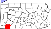
Boroughs Belle Vernon | Brownsville | Dawson | Dunbar | Everson | Fairchance | Fayette City | Markleysburg | Masontown | Newell | Ohiopyle | Perryopolis | Point Marion | Seven Springs‡ | Smithfield | South Connellsville | Vanderbilt
Townships Brownsville | Bullskin | Connellsville | Dunbar | Franklin | Georges | German | Henry Clay | Jefferson | Lower Tyrone | Luzerne | Menallen | Nicholson | North Union | Perry | Redstone | Saltlick | South Union | Springfield | Springhill | Stewart | Upper Tyrone | Washington | Wharton
CDPs Unincorporated
communitiesAcme | Adah | Farmington | Gans | Grindstone | Lake Lynn | Lemont Furnace | McClellandtown | Rowes Run | Star Junction | Whitsett | Wickhaven
Footnotes ‡This populated place also has portions in an adjacent county or counties
Categories:- Unincorporated communities in Pennsylvania
- Populated places in Fayette County, Pennsylvania
- Pennsylvania geography stubs

Wikimedia Foundation. 2010.