- Meadowvale Town Centre Bus Terminal
-
Meadowvale Town Centre Bus Terminal

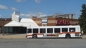
Station statistics Address 6677 Meadowvale Town Centre Circle, Mississauga ON Coordinates 43°35′00″N 79°45′31″W / 43.5833333°N 79.75861°WCoordinates: 43°35′00″N 79°45′31″W / 43.5833333°N 79.75861°W Lines Connections Structure bus loop Platforms 11 Parking no Other information Owned by City of Mississauga Presto card on buses The Meadowvale Town Centre Bus Terminal is the main, inter-regional transit hub for the community of Meadowvale located in northwestern Mississauga, Ontario, Canada. It is the third-largest terminal served by MiWay, the second-largest in Mississauga after City Centre Transit Terminal. It is situated on the eastern side of Meadowvale Town Centre, which is a community mall.
The terminal does not contain a building, partly due to the terminal being located directly beside the mall. Instead, it is composed of a big bus loop with benches and bus shelters surrounding it. MiWay buses lay over in the middle of the bus loop.
MiWay tickets and passes can be bought either at Arnie's Smoke, which is located within Meadowvale Town Centre; or at the Meadowvale Community Centre, located at the intersection of Glen Erin Drive and Aquitaine Avenue.[1] The nearest GO Transit ticket agency for this terminal is at a branch of Rabba Fine Foods located at the intersection of Derry Road and Glen Erin Drive, just north of the Meadowvale Community Centre [2].
Contents
Bus routes
Bus service within the terminal itself is exclusively by MiWay. However, GO Transit indirectly serves the terminal by stopping at the intersection of Aquitaine Avenue and Formentera Avenue, which requires a short walk from the bus loop.[3]
MiWay
Route Destination 9 Meadowvale 
Square One 10 Bristol Square One 13 Glen Erin Clarkson GO Station via Erin Mills Town Centre, South Common Centre and Sheridan Centre 27 Matheson Islington Subway Station 38 Creditview Trillium Health Centre via Meadowpine Boulevard 38A Trillium Health Centre via Argentia Road 39 Britannia Hershey Centre 42 Derry Westwood Mall 44 Mississauga Road Westdale Mall via University of Toronto Mississauga 45 Winston Churchill Clarkson GO Station via Royal Windsor Drive 45A Clarkson GO Station via Sheridan Research Park 48 Erin Mills South Common Centre via Erin Mills Town Centre and Credit Valley Hospital 57 Courtneypark Islington Subway Station via Pearson Airport Infield Terminal 89 Meadowvale-Subway Islington Subway Station 90 Terragar-Copenhagen Terragar Boulevard to Copenhagen Road 109 Meadowvale Express Islington Subway Station via Square One GO Transit
GO Transit buses stop at the intersection of Aquitaine Avenue and Formentera Avenue.
Route Destination 21 Milton Train-Bus Downtown Milton and Union Station Bus Terminal 27 Milton - Highway 401 Downtown Milton and Finch Bus Terminal 27A Downtown Milton and Finch Bus Terminal via Meadowvale Business Park 27B Downtown Milton and York Mills Bus Terminal 27E Derry Road at Winston Churchill and Finch Bus Terminal 48 Guelph - Highway 407 University of Guelph and York University References
Bus Terminals Canada's Wonderland • Credit Valley Hospital • Dixie Mall • Erin Mills Town Centre • Humber College (North) • Islington Subway Station • Kipling Subway Station • Meadowvale Town Centre • Pearson Airport • Sheridan Centre • Sheridan College (Brampton) • Sherway Gardens • Shoppers World (Brampton) • South Common • Square One/City Centre • Trillium Health Centre • University of Toronto Mississauga • Westwood Mall • Westdale Mall • Woodbine Centre
GO Stations Categories:- Transportation in Mississauga
- Bus stations in Ontario

Wikimedia Foundation. 2010.