- Qinghai
-
For other uses, see Qinghai (disambiguation).
Coordinates: 36°00′N 96°00′E / 36°N 96°E
Qinghai Province Chinese : 青海省 Qīnghǎi Shěng Abbreviations: 青 (pinyin: Qīng) 
Origin of name From Khoshut Oirat Köknuur:
Köke - blue
Nuur - Lake
"blue lake" (Qinghai Lake)
In Chinese:
青 qīng - green/blue
海 hǎi - sea
"qing (blue/green/black) sea"Administration type Province Capital
(and largest city)Xining CPC Ctte Secretary Qiang Wei Governor Luo Huining Area 721,000 km2 (278,000 sq mi) (4th) - Latitude 31° 32' to 39° 20' N - Longitude 089° 24' to 103° 04' E Population (2010)
- Density5,626,722 (30th)
7.48 /km2 (19.4 /sq mi) (30th)GDP (2010)
- per capitaCNY 135.1 billion (US$20.0 billion) (30th)
CNY 19,407 (22nd)HDI (2008) 0.720 (medium) (27th) Ethnic composition Han - 54%
Tibetan - 21%
Hui - 16%
Tu - 4%
Salar - 1.8%
Mongol - 1.8%Spoken dialects {{{Dialects}}} Prefectural level 8 divisions County level 43 divisions Township level* 429 divisions ISO 3166-2 CN-63 Official website
http://www.qh.gov.cn/
(Simplified Chinese)Source for population and GDP data: 《中国统计年鉴—2005》 China Statistical Yearbook 2005Source for nationalities data:
ISBN 7503747382《2000年人口普查中国民族人口资料》 Tabulation on nationalities of 2000 population census of China*As at December 31, 2004
ISBN 7105054255Template ■ Discussion ■ WikiProject China Qinghai Chinese name Chinese 青海 Hanyu Pinyin Qīnghǎi Transcriptions Hakka - Romanization Tshiâng-hói Mandarin - Hanyu Pinyin Qīnghǎi - Wade–Giles Ch'ing-hai - IPA tɕʰíŋxàɪ̯ - Postal Map Tsinghai
({{Audio|zh-Qinghai.ogg|Listen}})Min - Hokkien POJ Chheng-hái Wu - Romanization tshin平he上 Cantonese (Yue) - Jyutping cing1hoi2 Manchu name Manchu Huhu Noor Mongolian name Mongolian Köke Naγur Tibetan name Tibetan མཚོ་སྔོན་ Transcriptions - Wylie mtsho sngon Qinghai (
 listen (help·info)) (Chinese: 青海; pinyin: Qīnghǎi; Wade–Giles: Ching Hai, pronounced [tɕʰíŋxàɪ̯]); Oirat Mongolian: Көкнуур (transcribed into Cyrillic); Tibetan: མཚོ་སྔོན་; Salar:[citation needed]) is a province of the People's Republic of China, named after Qinghai Lake. It borders Gansu on the northeast, the Xinjiang Autonomous Region on the northwest, Sichuan on the southeast, and Tibet Autonomous Region on the southwest.
Contents
History
A large part of Qinghai, until the early 20th century most often referred to by its Mongol name Kokonur in English, lies outside of China proper and has been an ethnic melting pot for centuries, mixing Tibetan, Mongol, Turkic, Han Chinese influences. Although it preserved cultural and ethnic ties with central Tibet, it was ruled by local authorities during the last several centuries. It was a battleground during the Tang and subsequent Chinese dynasties when they fought against successive Tibetan tribes.[1]
In the middle of 3rd century CE, nomadic people related to Xianbei migrated to pasture lands around Koko Nur (Qinghai Lake) and established Tuyuhun Kingdom. Since the 7th century, Tuyuhun Kingdom was attacked by both Tibetan Empire and Tang Dynasty as both of them sought control over trade routes. Military conflicts severely weakened the kingdom and it was incorporated into Tibetan Empire. After the disintegration of Tibetan Empire, small local factions emerged. They were under titular authority of China and Tibet but maintained their autonomy. During the Mogolian rule, majority of Qinghai belonged to one of the three commandaries of Tibet, Amdo.
Tibetans reclaimed their independence from Yuan Dynasty in middle 14th century. Ming Dynasty claimed to have succeeded Mongol's authority over Tibet and remained as nominal ruler of the modern Qinghai region.
The Salars, who now live in the eastern outskirt of Qinhai province (Xunhua Salar Autonomous County), joined the Ming Dynasty around 1370, although the clans remained virtually independent in administration.[2]
From the late Ming to 1724, a big part of the area that is now Qinghai was under Khoshut Mongol control, but in that year it was conquered by the armies of the Qing Dynasty.[3] It was during 1720s when Xining Prefecture was established, despite its closeness to the rest of the Tibet, and its borders were roughly those of nowaday Qinghai province. Xining, the capital of modern Qinghai province was built in this period as the administrative center. During the rule of Qing Dynasty, the governor was a viceroy of the Qing Emperor, but the local Tibetans and other ethnic groups enjoyed much autonomy. Many chiefs retained retained their traditional authority, participating in local administrations.[4] The Dungan revolt (1895–1896) broke out in Qinghai in 1895. Following the overthrow of the Qing Dynasty, the region came under Chinese Muslim warlord Ma Qi control until the Northern Expedition by the Republic of China consolidated central control in 1928.
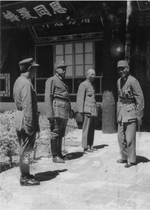
 Political and military leader of Nationalist China Chiang Kai-shek(right) meets with the Muslim Generals Ma Bufang (second from left), and Ma Buqing(first from left) in Xining, Qinghai at August 1942.
In July- August 1912, General Ma Fuxiang was "Acting Chief Executive Officer of Kokonur" (de facto Governof of the region that later became Qinghai).[5]
In 1928, Qinghai province was created. Previoiusly, it was part of Gansu province, as the "Tibetan frontier district".[6][7]
The Muslim warlord and General Ma Qi became military governor of Qinghai, followed by his brother Ma Lin (warlord) and then Ma Qi's son Ma Bufang.
Subsequently it became the primary base for the Muslim warlord Ma Bufang, before the Chinese Civil War ended and the People's Republic of China established with control over Qinghai and most of the rest of mainland China in 1949.
In 1932 Tibet invaded Qinghai, attempting to capture parts of southern Qinghai province, following contention in Yushu, Qinghai over a monastery in 1932. The army of Ma Bufang's defeated the Tibetan armies.
Governor of Qinghai, Ma Bufang was described as a socialist by American journalist John Roderick and friendly compared to the other Ma Clique warlords.[8] Ma Bufang was reported to be good humoured and jovial in contrast to the brutal reign of Ma Hongkui.[9]
Most of eastern China was ravaged by the Second Sino Japanese war the Chinese Civil, by contrast, Qinghai was relatively untouched.
An American scholar and government advisor, Doak Barnett, praised Ma Bufang's government as "one of the most efficient in China, and one of the most energetic. While most of China is bogged down, almost inevitably, by Civil War, Chinghai is attempting to carry out small-scale, but nevertheless ambitious, development and reconstruction schemes on its own initiative"
General Ma started a state run and controlled industralization project, directly creating educational, medical, agricultural, and sanitation projects, run or assisted by the state. The state provided money for food and uniforms in all schools, state run or private. Roads and a theater were constructed. The state controlled all the press, no freedom was allowed for independent journalists. His regime was dictatoral in its political system. Barnett admitted that the regime had "sterm authoritarianism" and "little room for personal freedom".[10]
Geography
 Satellite cross section of Qinghai.
Qinghai is located on the northeastern part of the Tibetan Plateau. The Yellow River (Huang He) originates in southern part of the province, while the Yangtze and Mekong have their sources in the southwestern part.
The average elevation of Qinghai is over 3000 meters above sea level. Mountain ranges include the Tanggula Mountains and Kunlun Mountains. Its average temperature is approximately −5 to 8 °C (23 to 46 °F), with January temperatures ranging from −18 to −7 °C (-0 to 19 °F) and July temperatures ranging from 15 to 21 °C (59 to 70 °F). It is also prone to heavy winds as well as sandstorms from February to April.
By area, Qinghai is the largest province in China - excluding autonomous regions, which are technically not provinces; but if they were, Xinjiang would be the largest.
Qinghai Lake (Koko Nor) is the largest salt water lake in China, and the second largest in the world.[citation needed]
Qaidam basin lies in northwestern Qinghai. About a third of this resource rich basin is desert. The basin has an altitude between 3000 to 3500 meters.
The Sanjiangyuan National Nature Reserve (SNNR), also referred to as the Sanjiangyuan Nature Reserve, or the Three Rivers Nature Reserve, is the area of Qinghai province, PRC which contains the headwaters of the Yellow River (Huang He), the Yangtze River (Chang Jiang), and the Mekong River (Lancang Jiang). The SNNR was established to protect the headwaters of these three rivers. The reserve consists of 18 subareas, each containing three zones which are managed with differing degrees of strictness.
Politics
Secretaries of the CPC Qinghai Committee Order Name Chinese Name Governance period 1 Zhang Zhongliang 张仲良 1949–1954 2 Zhao Shoushan 赵寿山 1952 3 Gao Feng[disambiguation needed  ]
]高峰 1954–1961 4 Wang Zhao 王昭 1961–1962 5 Yang Zhilin 杨植霖 1962–1966 6 Liu Xianquan 刘贤权 1967–1977 7 Tan Qilong 谭启龙 1977–1979 8 Liang Buting 梁步庭 1979–1982 9 Zhao Haifeng 赵海峰 1982–1985 10 Yin Kesheng 尹克升 1985–1997 11 Tian Chengping 田成平 1997–1999 12 Bai Enpei 白恩培 1999–2001 13 Su Rong 苏荣 2001–2003 14 Zhao Leji 赵乐际 2003–2007 15 Qiang Wei 强卫 2007-incumbent Governors of Qinghai Order Name Chinese Name Governance period 1 Zhao Shoushan 赵寿山 1950–1952 2 Zhang Zhongliang 张仲良 1952–1954 3 Sun Zuobin 孙作宾 1954–1958 4 Sun Junyi 孙君一 1958 5 Yuan Renyuan 袁任远 1958–1962 6 Wang Zhao 王昭 1962–1967 7 Liu Xianquan 刘贤权 1967–1977 8 Tan Qilong 谭启龙 1977–1979 9 Zhang Guosheng 张国声 1979–1982 10 Huang Jingbo 黄静波 1982–1985 11 Song Ruixiang 宋瑞祥 1985–1989 12 Jin Jipeng 金基鹏 1989–1992 13 Tian Chengping 田成平 1992–1997 14 Bai Enpei 白恩培 1997–1999 15 Zhao Leji 赵乐际 1999–2003 16 Yang Chuantang 杨传堂 2003–2004 17 Song Xiuyan 宋秀岩 2004–2010 18 Luo Huining 骆惠宁 2010 Administrative divisions
Main article: List of administrative divisions of QinghaiQinghai is administratively divided into one prefecture-level city, one prefecture, and six autonomous prefectures:
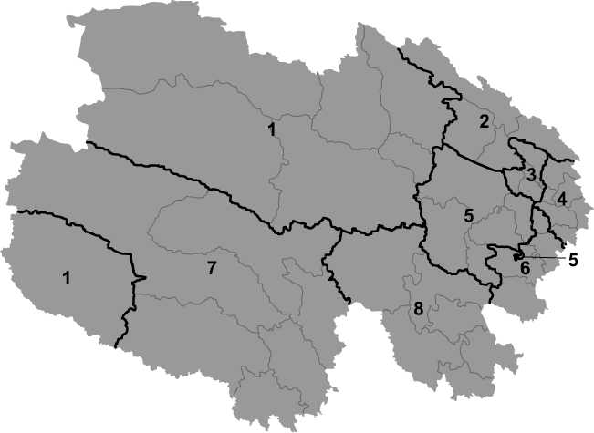
Map # Name Hanzi Hanyu Pinyin Administrative Seat 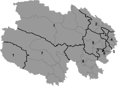
— Prefecture-level city — 3 Xining 西宁市 Xīníng Shì Chengzhong District — Prefecture — 4 Haidong 海东地区 Hǎidōng Dìqū Ping'an County — Autonomous prefecture — 1 Haixi (Mongol & Tibetan) 海西蒙古族藏族自治州 Hǎixī Měnggǔzú Zàngzú Zìzhìzhōu Delingha 2 Haibei (Tibetan) 海北藏族自治州 Hǎiběi Zàngzú Zìzhìzhōu Haiyan County 5 Hainan (Tibetan) 海南藏族自治州 Hǎinán Zàngzú Zìzhìzhōu Gonghe County 6 Huangnan (Tibetan) 黄南藏族自治州 Huángnán Zàngzú Zìzhìzhōu Tongren County 7 Yushu (Tibetan) 玉树藏族自治州 Yùshù Zàngzú Zìzhìzhōu Yushu County 8 Golog (Tibetan) 果洛藏族自治州 Guǒluò Zàngzú Zìzhìzhōu Maqên County All of these are in turn divided into four districts, two county-level cities, thirty counties, and seven autonomous counties.
Economy
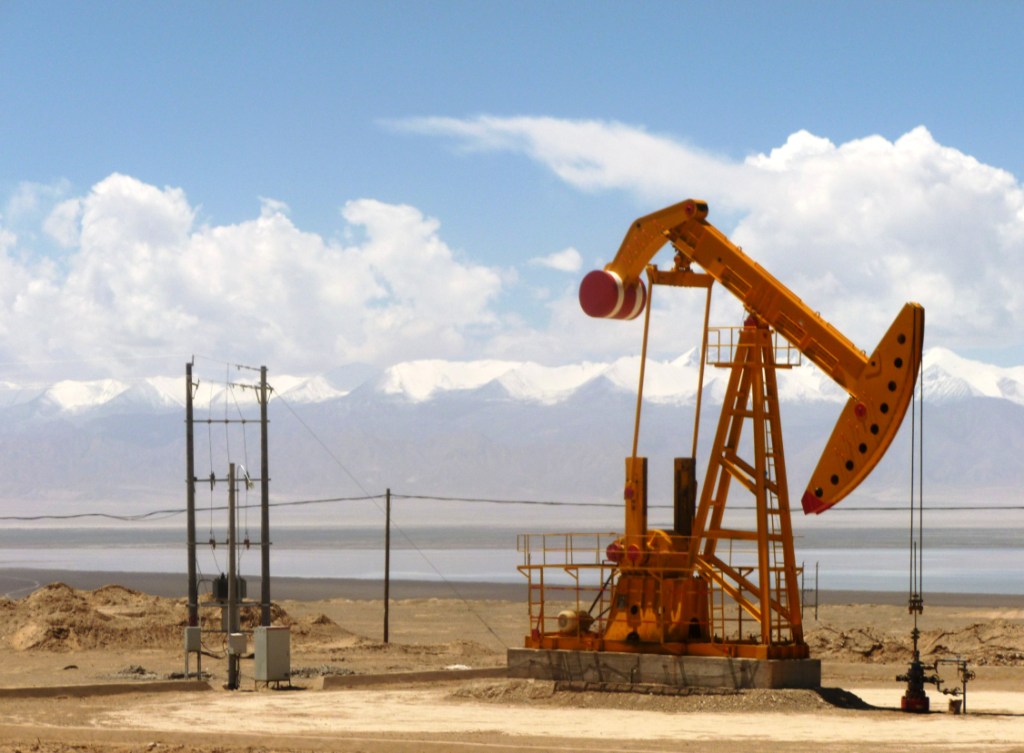
 Oil well in Tsaidam (Qaidam), Qinghai
Qinghai's economy is amongst the smallest in all of China. Its nominal GDP for 2009 was just 108.1 billion RMB (US$15.8 billion) and contributes to about 0.3% of the entire country's economy. Per capita GDP was 19,407 RMB (US$2,841), the second lowest in China.[11]
Its heavy industry includes iron and steel production, located near its capital city of Xining. Oil and natural gas from the Chaidamu Basin have also been an important contributor to the economy.[12]
Outside of the provincial capital, Xining, most of Qinghai remains underdeveloped. Qinghai ranks second lowest in China in terms of highway length, and will require a significant expansion of its infrastructure to capitalize on the economic potential of its rich natural resources.[13]
Economic and Technological Development Zones
- Xining Economic & Technological Development Zone
Xining Economic & Technological Development Zone (XETDZ) was approved as state-level development zone in July 2000. It has a planned area of 4.4 square kilometers. XETDZ lies in the east of Xining, the capital city of Qinghai Province, 5 kilometers away from downtown. Located in the east of the province, Xining stands at the upper reaches of the Huangshui River-one of the Yellow River's branches. The city is surrounded by the mountains with an average elevation of 2261 meters and the highest at 4393 meters. Xining Economic and Technological Development Zone (XETDZ) is the first of its kind at the national level on the Qinghai-Tibet Plateau. It is established to fulfill the nation's strategy of developing the west.
XETDZ enjoys a convenient transportation system, connected by the Xining-Lanzhou expressway and run through by two main roads, the broadest roads of the city. It is 4 kilometers away from the railway station, 15 kilometers from Xi'ning Airport, a grade 4D airport with 14 airlines to other cities such as Beijing, Guangzhou, Shanghai, Chengdu and Xi'an. Xining is Qinghai province's passage to the outside world, a transportation center with more than ten highways, over one hundred roads and two railways, Lanzhou-Qinghai and Qinghai-Tibet Railways in and out of the city.
It focuses on the development of following industries: chemicals based on salt lake resources, nonferrous metals, and petroleum and natural gas processing; special medicine, foods and bio-chemicals using local plateau animals and plants; new products involving ecological and environmental protection, high technology, new materials as well as information technology; and services such as logistics, banking, real estate, tourism, hotel, catering, agency and international trade.[14]
Demographics
 The Dongguan Mosque in Qinghai
The population of Qinghai is approximately 5.2 million, among which the Han account for 54.5%. Other groups include the Tibetans 20.87%, Hui 16%, Tu (Monguor) 4%, Salar, and Mongols.
Culture
Qinghai's culture is heavily influenced by China proper and Tibet, given the close proximities as well as a shared history.
Transportation
See also: Transport in the People's Republic of ChinaThe Lanqing Railway, running between Lanzhou, Gansu and Xining, the province's capital, was completed in 1959 and is the major transportation route in and out of the province. A continuation of the line, the Qinghai-Tibet Railway via Golmud and western Qinghai, has become one of the most ambitious projects in PRC history. It was completed in October 2005 and now links Tibet with the rest of China through Qinghai.
Six National Highways run through the province.
Xining Caojiabu Airport provides service to Beijing, Lanzhou, Golmud and Delingha. Smaller regional airports, such as Golmud Airport and Yushu Batang Airport, serve some of the local centers of the far-flung province; plans exist for the construction of three more by 2020.[15]
Telecommunications
See also: Telecommunications industry in ChinaSince the Ministry of Information Industry began its "Access to Telephones Project", Qinghai has invested 640 million yuan to provide telephone access to 3860 out its 4133 administrative villages. At the end of 2006, 299 towns had received Internet access. However, 6.6 percent of villages in the region still have no access to the telephone. These villages are mainly scattered in Qingnan Area, with 90 percent of them located in Yushu and Guoluo. The average altitude of these areas exceeds 3600 meters, and the poor natural conditions hamper the establishment of telecommunication facilities in the region.
Satellite phones have been provided to 186 remote villages in Qinghai Province as of September 14, 2007. The areas benefited were Yushu Tibetan Autonomous Prefecture and Guoluo Tibetan Autonomous Prefecture. Qinghai has recently been provided with satellite telephone access. In June 2007, China Satcom carried out an in-depth survey in Yushu and Guoluo, and made a special satellite phones for these areas. Two phones were provided to each village for free, and calls were charged at the rate of 0.2 yuan per minute for both local and national calls, with the extra charges assumed by China Satcom. No monthly rent was charged on the satellite phone. International calls were also available.
Tourism
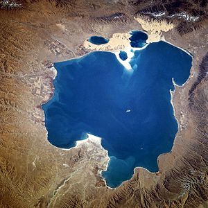 Qinghai Lake from space, November 1994.
Many tourist attractions center on Xining, the provincial seat of Qinghai.
During the hot summer months, many tourists from the hot Southern and Eastern parts of China travel to Xining, as the climate of Xining in July and August is quite mild and comfortable, making the city an ideal summer retreat.
Qinghai Lake (青海湖, qīnghǎi hú) is another tourist attraction, albeit further from Xining than Kumbum. The lake is the largest saltwater lake in China, and is also located on the "Roof of the World," the Tibetan Plateau. The lake itself lies at 3,600m elevation. The surrounding area is made up of rolling grasslands and populated by ethnic Tibetans. Most pre-arranged tours stop at Bird Island (鸟岛, niǎo dǎo). An international bicycle race takes place annually from Xining to Qinghai Lake.
Colleges and universities
- Qinghai University (青海大学)
- Qinghai Radio & Television University
Also see List of universities and colleges in Qinghai
See also
- 2010 Yushu earthquake
- Geladandong
- Haplogroup D1 (Y-DNA)
- Haplogroup O3 (Y-DNA)
- Tectonic summary of Qinghai Province
References
- ^ Purdue - Tibetan history.
- ^ James Stuart Olson (1998). An ethnohistorical dictionary of China. Greenwood Publishing Group. p. 297. ISBN 0313288534. http://books.google.de/books?id=IOM8qF34s4YC&pg=PA297&dq=salar+xinjiang&hl=de&ei=aLrOTdLFN7Tr0QH6__meDg&sa=X&oi=book_result&ct=result&resnum=6&ved=0CEgQ6AEwBQ#v=onepage&q=salar%20xinjiang&f=false. Retrieved 6-3-2011.
- ^ The Times Atlas of World History. (Maplewood, New Jersey: Hammond, 1989) p. 175
- ^ M.C. Goldstein (1994). Barnett and Akiner. ed. Change, Conflict and Continuity among a community of nomadic pastoralists—A Case Study from western Tibet, 1950-1990., Resistance and Reform in Tibet. London: Hurst & Co..
- ^ Henry George Wandesforde Woodhead, Henry Thurburn Montague Bell (1969). The China year book, Part 2. North China Daily News & Herald. p. 841. http://books.google.com/books?ei=n2vsTcSEOI6itgeuqdGgAQ&ct=result&id=Tb8ZAAAAIAAJ&dq=Ma+Fu-hsiang%2C+%28%24y+fi%5Efll%5E%29.+%E2%80%94+Kansu.+Brigade-General.+Paiikun%2C+New+Dominion.+March.+1909.+Acting+Chief+Executive+Officer%2C+Kokonor%2C+July-+August%2C+1912.+Commander+of+Guards+Division.+Altai%2C+October+10.+1912.+Was+Military+Commissioner+of&q=+kokonor+officer+executive. Retrieved 2011-06-05.
- ^ Louis M. J. Schram (2006). The Monguors of the Kansu-Tibetan Frontier: Their Origin, History, and Social Organization. Kessinger Publishing. p. 17. ISBN 1-4286-5932-3. http://books.google.com/books?id=sy2FOZy0kTsC&pg=PA57&dq=muslims+lung+period+to+save+their+lives+at+a+time+when+the+region+was+dominated+by+rebellious+muslims&hl=en&ei=v8_FTdLAC6230QHrzuj1Bw&sa=X&oi=book_result&ct=result&resnum=1&ved=0CDYQ6AEwAA#v=snippet&q=province%20of%20ch'inghai%20established%20in%201928%20until%20then%20constituted%20the%20tibetan%20district%20of%20the%20province%20of%20kansu&f=false. Retrieved 2010-06-28.
- ^ Graham Hutchings (2003). Modern China: a guide to a century of change (illustrated, reprint ed.). Harvard University Press. p. 351. ISBN 0674012402. http://books.google.com/books?id=qhe6vP66jN0C&pg=PA351&dq=They+did+not,+however,+control+political+life+in+the+province.+This+was+in+the+hands+of+the+Ma+clan+of+Hui+Muslims,+the+third+most+numerous+ethnic+group+after+the+Han+and+the+Tibetans.+Governor+Ma+Bufang+(19o2-75)+dominated+Qinghai&hl=en&ei=ktXlTe2KLYbZgQf-59CECw&sa=X&oi=book_result&ct=result&resnum=1&ved=0CCoQ6AEwAA#v=onepage&q=They%20did%20not%2C%20however%2C%20control%20political%20life%20in%20the%20province.%20This%20was%20in%20the%20hands%20of%20the%20Ma%20clan%20of%20Hui%20Muslims%2C%20the%20third%20most%20numerous%20ethnic%20group%20after%20the%20Han%20and%20the%20Tibetans.%20Governor%20Ma%20Bufang%20(19o2-75)%20dominated%20Qinghai&f=false. Retrieved 2010-6-28.
- ^ John Roderick (1993). Covering China: the story of an American reporter from revolutionary days to the Deng era. Imprint Publications. p. 104. ISBN 1879176173. http://books.google.com/books?id=nDgbAQAAIAAJ&q=ma+bufang+taiwan&dq=ma+bufang+taiwan&hl=en&ei=QBHJTJXABML7lwfXne3nAQ&sa=X&oi=book_result&ct=result&resnum=2&ved=0CC4Q6AEwATgK. Retrieved 2010-06-28.
- ^ Felix Smith (1995). China pilot: flying for Chiang and Chennault. Brassey's. p. 140. ISBN 1574880519. http://books.google.com/books?id=PRbvAAAAMAAJ&q=Ma-Hung-kwei&dq=Ma-Hung-kwei&hl=en&ei=_66VTMidJ4OdlgfB2ZiqCg&sa=X&oi=book_result&ct=result&resnum=6&ved=0CEUQ6AEwBTgK. Retrieved 2010-06-28.
- ^ Werner Draguhn, David S. G. Goodman (2002). China's communist revolutions: fifty years of the People's Republic of China. Psychology Press. p. 38. ISBN 0700716300. http://books.google.com/books?id=0Caknr1VAqMC&pg=PA38&dq=ma+bufang+communist+saw&hl=en&ei=dYegTcupA-iO0QHU4OWEBQ&sa=X&oi=book_result&ct=result&resnum=1&ved=0CCgQ6AEwAA#v=onepage&q&f=false. Retrieved 2011-04-09.
- ^ http://www.thechinaperspective.com/topics/province/qinghai-province/
- ^ http://www.thechinaperspective.com/topics/province/qinghai-province/
- ^ http://www.thechinaperspective.com/topics/province/qinghai-province/
- ^ RightSite.asia | Xining Economic & Technological Development Zone
- ^ Qinghai to build 3 new airports before 2020
External links

Xingjiang Gansu 
 Qinghai

Tibet Autonomous Region Sichuan Qinghai topics General Geography Cities • Tibetan Plateau • Yellow River • Yangtze River • Mekong River • Tanggula Mountains • Kunlun Mountains • Qinghai Lake • Qaidam Basin • Sanjiangyuan National Nature ReserveEducation Qinghai University • Qinghai Normal University • Qinghai University for Nationalities • Qinghai Medical CollegeCulture Cuisine LiangfenVisitor attractions Qinghai Province county-level divisions Xining: Chengzhong District · Chengdong District · Chengxi District · Chengbei District · Datong County · Huangyuan County · Huangzhong County Qinghai in China
Haidong: Ping'an County · Ledu County · Minhe County · Huzhu County · Hualong County · Xunhua County
Haibei: Haiyan County · Qilian County · Gangca County · Menyuan County
Hainan: Gonghe County · Tongde County · Guide County · Xinghai County · Guinan County
Huangnan: Tongren County · Jainca County · Zêkog County · Henan County
Golog: Maqên County · Baima County · Gadê County · Darlag County · Jigzhi County · Madoi County
Yushu: Yushu County · Zadoi County · Chindu County · Zhidoi County · Nangqên County · Qumarleb County
Haixi: Delingha City · Golmud City · Wulan County · Dulan County · Tianjun CountyAdministrative Committees: Lenghu · Da Qaidam · Mangya1
^1 — The administrative committees are not standard units of local government, though they do function as such.
■ = Prefecture-level city ■ = Prefecture ■ = Autonomous prefecturesProvincial level divisions of the People's Republic of China Provinces 
Autonomous regions Municipalities Special Administrative Regions Territorial disputes - Paracel, Spratly, Zhongsha Islands (see Paracels, Spratlys, & Zhongsha Iss. Authority)
- Pratas Islands
- Senkaku Islands
- South Tibet
- Taiwan, Kinmen & Matsu (see Legal status of Taiwan)
Categories:- Qinghai
- Provinces of the People's Republic of China
- Governors of Qinghai
- Amdo
- States and territories established in 1928


Wikimedia Foundation. 2010.