- Medora Site
-
Medora Site
16WBR1
Diagram of the Medora Site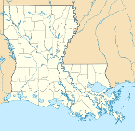
 Medora SiteLocation within Louisiana today
Coordinates: 30°19′36.34″N 91°12′5.65″W / 30.3267611°N 91.2015694°W Location Country:  USA
USARegion: West Baton Rouge Parish, Louisiana Nearest town: Plaquemine, Louisiana History Culture: Plaquemine culture First occupied: 1300 CE Excavation and maintenance Responsible body: private Dates excavated: 1939-1940 Notable archaeologists: Dr. James A. Ford, George I. Quimby Architecture Architectural styles: Platform mounds, Plaza The Medora Site(16WBR1) is an archaeological site that is a type site for the prehistoric Plaquemine culture period. The name for the culture is taken from the proximity of Medora to the town of Plaquemine, Louisiana.[1] The site is in West Baton Rouge Parish, Louisiana, and was inhabited from approximately 1300 to 1600 CE. It consisted of two mounds separated by a plaza. In the winter of 1939-40 excavation of this site was undertaken by the Louisiana State Archaeological Survey, a joint project of Louisiana State University and the Work Projects Administration. It was directed by Dr. James A. Ford, and George I. Quimby. The excavations of the site were instrumental in defining the characteristics of the Plaquemine period and culture.[2]
Contents
The Medora Site
Location
 A map showing the geographical extent of the Plaquemine culture, including the Medora site.
The Medora Site is located in West Baton Rouge Parish, Louisiana adjacent to Bayou Bourbeaux (or Bourbeau or Bourbaux) on the flood plain of Manchac Point (also called Australia Point). Manchac Point is a hair-pin bend of the Mississippi River. Bayou Bourbeaux, a point stream which flows away from the river to the west, drains the back slopes of the natural levees that border Manchac Point, and connects with Bayou Gross Tete. The land surrounding the site is wet and subject to annual flooding, being only twenty feet above sea level. The site is part of the Medora Plantation, after which it is named, and had been cultivated for many years prior to the excavation.[2]
Date
It was possible to date the site by geological and archaeological means and obtain an estimate of the period of time in which the site was occupied. According to the Louisiana Geological Survey abandoned river course maps of Harold Norman Fisk, a meander of the Mississippi River began migrating from north to south across the area now occupied by Manchac Point at stage 9 (900 CE). The land of which Manchac Point is composed was not built up behind the meander until the beginning of stage 13 (1300 CE), meaning it was not suitable for habitation until then. And since all artifacts found at the site were from the Plaquemine period and not the succeeding Natchez period which begins in 1700, the dates for occupation are approximately from 1300 to 1600 CE.[2]
Mounds
The main part of the Medora Site is a pyramid and plaza arrangement. Mound A is a platform mound about 125 feet (38 m) to 130 feet (40 m) at the base and 10 feet (3.0 m) high. The sides sloped inward toward the top, which is flat, except for a conical projection 25 feet (7.6 m) in diameter in the northeast corner of the summit that raises the gross elevation to 13 feet (4.0 m). It was probably surmounted by a square or rectangular temple. About 400 feet (120 m) to the southeast of Mound A was a low mound about 100 feet (30 m) in diameter and 5 feet (1.5 m) high, designated Mound B. Although it has been modified by plowing and flood waters, and is now only about 2 feet (0.61 m) high. It was flat-topped, with an irregular oval outline. Its pre-mound surface was found to have a wall-trench structure, probably a house or temple. The floor contained patches of burned clay and fragments of charcoal. At the center there was a rounded fire basin 2 feet (0.61 m) in diameter and six inches deep, lined with burned clay. The mounds were composed of gray clay and brown silt, applied basket load at a time. Between Mounds A and B was a plaza about 400 feet (120 m) long and 200 feet (61 m) wide. Its west side bordered Bayou Bourbeaux.[2]
Artifacts
Pottery
 Plaquemine culture pottery from the Winterville Site, a Plaquemine site in Mississippi
About 18,508 pottery sherds were obtained from the Medora Site, classified into more than twenty different pottery types. About 90 per cent were classified as the Addis Plain variety, although Plaquemine Brushed; Manchac Incised; Hardy Incised; Medora Incised; Harrison Bayou Incised; Evangeline Interior Incised; Australia Interior Incised; L'Eau Noire Incised; Dupree Incised; Lulu Linear Punctated; Chevalier Stamped, Coles Creek Incised, Larto Red Filmed, and Pontchartrain Check Stamped were also present.[2]
The pottery of the Medora Site was uniform in paste characteristics, soft, clay-tempered, and poorly fired, with the exception of a few shell-tempered sherds. The color generally ranges in grays and tans, with a smooth surface finish that feels soft and chalky to the touch. Although the vast majority of the pottery was plain, about 10 percent had decorative elements applied. The designs were usually simple arrangements of lines, made by incising, engraving, brushing, and punctating, with incising and brushing the most common technique. A few of the type L'Eau Noire Incised have complicated curvilinear elements. The designs are usually placed on the exterior vessel wall, mostly confined to the rim. The most common vessel forms were jars and bowls, with some cups and carinated bowls.[2]
Stone
Although more than 18,000 pottery sherds were found, only seven artifacts of stone were found at the Medora Site. Reddish pebbles of flinty stone were found in Mound A , even though they do not naturally occur in the vicinity of the Medora Site. They must have been brought there, possibly from the Natchez, Mississippi vicinity. Only three projectile points of chipped flint were found at the site, although several objects of polished greenstone and sandstone were found. Two ovate-oblong greenstone celts and a sandstone discoidal were found in the fill of Mound A. A spoon-shaped object of ground and polished greenstone was found in the fill Mound B. A discoidal was probably used in the well-known game of chunkey, which was played by almost all of the historic Indians of the Southeast. It is very likely that chunkey was played ceremonially in the plaza of the Medora Site. A cylindrical earspool of fired clay with flat faces and straight sides was found in Mound A. It was 3 centimetres (1.2 in) in diameter and 1.8 centimetres (0.71 in) thick, with engraved geometric designs composed of a circle and curvilinear elements.[2]
Excavations
The land is part of the Medora Plantation, after which the site is named, and had been cultivated for many years prior to the excavation.In the winter of 1939-40 excavation of this site was undertaken by the Louisiana State Archaeological Survey, a joint project of Louisiana State University and the Work Projects Administration. It was directed by Dr. James A. Ford, and George I. Quimby. The excavations of the site were instrumental in defining the characteristics of the Plaquemine period and culture. Permission to investigate this site was given by the owner of the land, Mr. W. L. Grace, Jr., of Plaquemine, Louisiana.[2]
See also
References
- ^ "Louisiana Comprehensive Statewide Historic Preservation Plan". September 28, 2001. http://74.125.95.132/search?q=cache:asBq7TRLJQIJ:www.crt.state.la.us/hp/2001%2520Strategic%2520Plan.doc+medora+site+plaquemine+culture&cd=20&hl=en&ct=clnk&gl=us. Retrieved 2009-05-30.
- ^ a b c d e f g h Quimby, George Irving (1951). Anthropological Series, Field Museum of Natural History, Volume XXIV, Number 2. Chicago Field Museum Press.
External links
 Pre-Columbian North America
Archaeological cultures North American pre-Columbian chronology – Adena – Alachua – Ancient Pueblo (Anasazi) – Baytown – Belle Glade – Buttermilk Creek Complex – Caborn-Welborn – Calf Creek – Caloosahatchee – Clovis – Coles Creek – Deptford – Folsom – Fort Ancient – Fort Walton – Fremont – Glades – Glacial Kame – Hopewell (List of Hopewell sites) – Hohokam – Leon-Jefferson – Mississippian (List of Mississippian sites) – Mogollon – Monongahela – Old Cordilleran – Oneota – Paleo-Arctic – Paleo-Indians – Patayan – Plano – Plaquemine – Poverty Point – Prehistoric Southwest – Red Ocher – Santa Rosa-Swift Creek – St. Johns – Steed-Kisker – Tchefuncte – Tocobaga – Troyville
Archaeological sites Angel Mounds – Bandelier National Monument – The Bluff Point Stoneworks – Cahokia – Chaco Canyon – Casa Grande – Coso Rock Art District – Eaker – Effigy Mounds National Monument – Etowah Indian Mounds – Eva – Folsom Site – Fort Ancient – Fort Center – Gila Cliff Dwellings National Monument – Holly Bluff Site – Hopewell Culture National Historical Park – Kincaid Mounds – Kolomoki – Manitou Cliff Dwellings – Marksville – Meadowcroft Rockshelter – Mesa Verde – Moorehead Circle – Moundville – Mummy Cave – Nodena Site – Ocmulgee National Monument – Old Stone Fort – Parkin Park – Pinson Mounds – Portsmouth Earthworks – Poverty Point – Pueblo Bonito – Rock Eagle – Rock Hawk – Salmon Ruins – Serpent Mound – Spiro Mounds – SunWatch – Taos Pueblo – Toltec Mounds – Town Creek Indian Mound – Winterville
Miscellaneous Ballgame – Black drink – Buhl woman – Calumet – Chunkey – Clovis point – Container Revolution – Eastern Agricultural Complex – Eden point – Effigy mound – Falcon dancer – Folsom point – Green Corn Ceremony – Horned Serpent – Kennewick man – Kiva – Metallurgy – Mi'kmaq hieroglyphic writing – Medicine wheel – Mound builders – N.A.G.P.R.A. – Norse colonization of the Americas – Piasa – Pueblo dwellings – Southeastern Ceremonial Complex – Three Sisters agriculture – Thunderbird – Underwater panther
Related: Genetic history · Indigenous Portal of North America · Pre-Columbian era Categories:- Plaquemine Mississippian culture
- Archaeological sites in Louisiana
- Geography of West Baton Rouge Parish, Louisiana
- Mounds in the United States
- Type sites


Wikimedia Foundation. 2010.