Megget Water

Megget Water
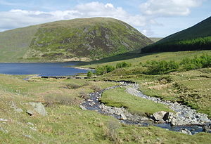
The Megget Reservoir and Megget Water, Selkirkshire
Not to be confused with the nearby Meggat Water which is a tributary of the Border Esk.

Megget Water is a river in the Scottish Borders area of Scotland, in the former Selkirkshire. The Water rises at Broad Hill, passes through Megget Reservoir and empties into St Mary's Loch. Places in the vicinity include Cappercleuch, Craigierig, Cramalt Tower, the Glengaber Burn, Meggethead Farm.

The area is of geological and archaeological interest, through stone artifacts at Henderland in the parish of Yarrow (now in Wilton Lodge Museum, Hawick), and discoveries of gold.

See also

References

  • NMS (1992d), 'Megget Water (Yarrow parish):cup-marked stone', Discovery Excav Scot, page 7
  • Scottish Journal of Geology (The Geological Society}: R.J.Chapman, R.C.Leake, J.D,Floyd: Regional variation in gold mineralization in the vicinity of the Glengaber Burn, Scottish Borders
  • Proc Soc Antiq Scot, III, 1981, 401-429, Cramalt Tower:historical survey and excavations 1977-9, Alastair M T Maxwell-Irving

External links

Coordinates: 55°29′23″N 3°11′58″W / 55.4897°N 3.1994°W / 55.4897; -3.1994


Wikimedia Foundation. 2010.

Игры ⚽ Поможем сделать НИР

Look at other dictionaries:

  • Megget Reservoir — Location Scottish Borders Coordinates …   Wikipedia

  • Lyne and Megget —    LYNE and MEGGET, a parish, in the county of Peebles, 5 miles (W.) from Peebles; containing 175 inhabitants. The district of Lyne, though consisting only of two farms, is, from being the site of the parochial church and manse, regarded as the… …   A Topographical dictionary of Scotland

  • Fruid Water — Infobox lake lake name = Fruid Water image lake = caption lake = image bathymetry = caption bathymetry = location = Scottish Borders, Scotland coords = Coord|55|27|30|N|3|25|50|W|region:GB type:waterbody|display=inline,title type = reservoir… …   Wikipedia

  • St. Mary’s Loch — Geographische Lage Scottish Borders, Schottland Zuflüsse …   Deutsch Wikipedia

  • Peeblesshire, or Tweeddale —    PEEBLESSHIRE, or TWEEDDALE, an inland county, in the southern part of Scotland, bounded on the north by Edinburghshire, on the east by Selkirkshire and Edinburghshire, on the south by the county of Dumfries, and on the west by Lanarkshire. It… …   A Topographical dictionary of Scotland

  • Moffat Hills — The Moffat hills[1] are a range of hills in the Southern Uplands of Scotland. They form a distinctly triangular shape with a west facing side, a north facing side, and a south east facing side. It is 17 kilometres from east to west across this… …   Wikipedia

  • Westerkirk —    WESTERKIRK, a parish, in the county of Dumfries, 6 miles (N. W.) from Langholm; containing 638 inhabitants. This place is by some writers supposed to have derived its name, originally Wester Ker or Wester Caer, from its situation to the west… …   A Topographical dictionary of Scotland

  • List of Statutory Instruments of the United Kingdom, 1987 — This is a complete list of all 1468 Statutory Instruments published in the United Kingdom in the year 1987. NOTOC 1 100* Parish and Community Meetings (Polls) Rules 1987 S.I. 1987/1 * National Health Service (Food Premises) (Scotland) Regulations …   Wikipedia

  • List of reservoirs and dams in the United Kingdom — This is a list of reservoirs and dams in the United Kingdom.EnglandBedfordshireBuckinghamshire*Foxcote Reservoir, north of Buckingham *Weston Turville Reservoir, between Weston Turville and WendoverCambridgeshire*Grafham WaterCheshire*Bosley… …   Wikipedia

  • List of dams and reservoirs in the United Kingdom — Contents 1 England 1.1 Bedfordshire 1.2 Buckinghamshire 1.3 …   Wikipedia

Share the article and excerpts

Direct link
Do a right-click on the link above
and select “Copy Link”