- Meonstoke (hundred)
-
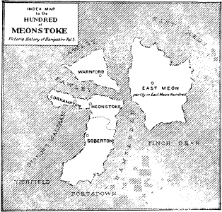
 The Meonstoke Hundred as known in the mid 1880s. The Hundred of Meonstoke is highlighted in white.
The Hundred of Meonstoke was a small Hundred of Great Britain situated in the ceremonial county of Hampshire. The Hundred of Meonstoke contained the parishes of; Abbots Worthy, Alverstoke, Corhampton, Exton, Hambledon, Liss, Meonstoke, Soberton, Warnford, and West Meon (which was partly in the East Meon Hundred). Before the time of the Domesday Survey, Bramdean was included in the Meonstoke Hundred until it was transferred to the Finchdean Hundred.[1]
The land comprising the hundred was assessed in the reign of Edward the Confessor at 89 hides, and at the time of the survey at estimated to be about 56 hides. By the beginning of the fourteenth century the area of the hundred had much decreased. West Meon, Exton, Alverstoke, Abbots Worthy, Liss and a large part of the parish of Hambledon had been removed and transferred in to the Odiham Hundred.[2] From this date the extent of the hundred remained practically unchanged until after 1831.
This hundred has always belonged to the crown. In a survey of the hundred taken in the Commonwealth period it was stated that the courts-leet and law-days of the hundred were still then held at Easter and Michaelmas and that the three-weeks' courts or sheriff's tourns were also regularly held.[3]
The Hundred of Meonstoke is one of the smallest hundreds in Hampshire.
References
- ^ Manor, vill, and hundred: the development of rural institutions in early medieval Hampshire. Eric C. Klingelhöfer. 1992. pp. 134. http://books.google.com/books?id=20yTAAAAIAAJ&q=bramdean+hundred&dq=bramdean+hundred&hl=en&ei=hOakTKWAPZaSjAfayoyqDA&sa=X&oi=book_result&ct=result&resnum=1&ved=0CCUQ6AEwAA.
- ^ The Antiquary: a magazine devoted to the study of the past, Volume 29. Edward Walford. 1884. pp. 101. http://books.google.com/books?id=pBmx9w1E9wsC&q=meonstoke+hundred&dq=meonstoke+hundred&hl=en&ei=1uekTLj0KZKTjAfM-N22DA&sa=X&oi=book_result&ct=result&resnum=1&ved=0CCgQ6AEwAA.
- ^ Survey of medieval Winchester. Derek Keene. 1985. pp. 865. http://books.google.com/books?id=Q-CEzid6iNkC&pg=PA865&dq=Parl.+Surv.+Hants,+No.+8.&hl=en&ei=teikTOn1IJbKjAe2n4SrDA&sa=X&oi=book_result&ct=result&resnum=4&ved=0CD4Q6AEwAw#v=onepage&q&f=false.
See also
- The Hundred of Odiham
- The Hundred of Bishops Sutton
Alton | Alverstoke | Andover | Basingstoke | Bishops Sutton | Bosmere | Budlesgate | Christchurch | Crondall | East Meon | Fawley | Finchdean | Kings Somborne | Meonstoke | Odiham | Selborne
Categories:- Culture in Hampshire
Wikimedia Foundation. 2010.