- Mewstone
-
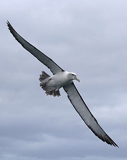 Mewstone is an important breeding site for Shy Albatrosses
Mewstone is an oval 13.1 ha island, composed of muscovite granite, with steep cliffs and a small flat summit.[1] It is part of the Pedra Branca Group, lying 12 km south-east of Maatsuyker Island, and 22 km off the south coast of Tasmania in south-eastern Australia.[2] Its highest point is 150 m asl.[1] Although it is sometimes referred to as Mewstone Island or The Mewstone, its official name is simply Mewstone.[3] It is part of the Southwest National Park and the Tasmanian Wilderness World Heritage Site and is known for its inaccessibility, unusual shape and abundant bird life. It has been identified by BirdLife International as an Important Bird Area (IBA) because it supports over 1% of the world populations of Shy Albatrosses and Fairy Prions.[4]
Contents
History
In 1642 it was described by Abel Tasman, who said it "resembles a lion".[5] In 1773 it was named by Tobias Furneaux.[6]
Flora and fauna
There is very little flora due to the rocky nature of the island. What little plant life there is grows in crevices in the rocks where soil has accumulated.[7]
Recorded breeding seabirds include Fairy Prion (20,000 pairs), Silver Gull, Black-faced Cormorant and Shy Albatross (7,500 pairs). Mewstone is the largest of only three Shy Albatross breeding colonies in the world, the other two being Albatross Island and Pedra Branca.[2] Australian Fur Seals haul-out on small ledges. The Tasmanian Tree Skink is present.[1]
References
- ^ a b c Brothers, Nigel; Pemberton, David; Pryor, Helen; & Halley, Vanessa. (2001). Tasmania’s Offshore Islands: seabirds and other natural features. Tasmanian Museum and Art Gallery: Hobart. ISBN 0-7246-4816-X
- ^ a b "Small Southern Islands Conservation Management Statement 2002" (PDF). Tasmania Parks and Wildlife Service. 2002. http://www.parks.tas.gov.au/IslandCare/southern_islands.pdf. Retrieved 2006-07-20.
- ^ "Place Name Search for mewstone, tasmania". Geoscience Australia. http://www.ga.gov.au/bin/gazm01?placename=mewstone&placetype=0&state=TAS. Retrieved 2006-07-24.
- ^ "IBA: Mewstone". Birdata. Birds Australia. http://www.birdata.com.au/iba.vm. Retrieved 2011-08-15.
- ^ Heeres, J E (Editor) (2006). "Abel Janszoon Tasman's Journal of his Discovery of Van Diemen's Land and New Zealand in 1642 with Documents Relating to his Exploration of Australia in 1644...to which are added his Life and Labours, 1898". Project Gutenberg of Australia. http://gutenberg.net.au/ebooks06/0600571h.html. Retrieved 2006-07-09.
- ^ "Furneaux, Tobias (1735 - 1781)". Australian Dictionary of Biography Online Edition. Research School of Social Sciences, Australian National University. 2006. http://www.adb.online.anu.edu.au/biogs/AS10174b.htm. Retrieved 2006-07-23.
- ^ White, Gary. Islands of South-West Tasmania. Sydney: self-published. ISBN 0-9594866-0-7.
External links
Coordinates: 43°44′17″S 146°22′16″E / 43.73806°S 146.37111°E
Categories:- Islands of Tasmania
- Protected areas of Tasmania
- South West Tasmania
- Important Bird Areas of Australia
- Tasmania geography stubs

Wikimedia Foundation. 2010.