- Mexico City's boroughs
-
Mexico City — politically and administratively constituted as the Federal District — is divided into sixteen boroughs (Spanish: delegaciones) for administrative purposes. They constitute second-level administrative divisions, on par with the municipalities of Mexico. However, unlike municipalities, they do not have regulatory powers and are not fully autonomous in their internal administration. As of 2000, the citizens within a borough elect by plurality a head of government, known simply as "borough head" (Spanish: jefe delegacional). The DF recorded an official 2010 census tally of 8,851,080 inhabitants.[1]
Contents
Administrative divisions
Boroughs of the Federal District 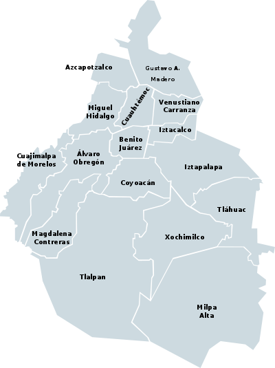
Borough Population (2005)[2] Population (2010)[3] Area (km²)[2] Álvaro Obregón 706,567 727,034 96 Azcapotzalco 425,298 414,711 34 Benito Juárez 355,017 385,439 27 Coyoacán 628,063 620,416 54 Cuajimalpa 173,625 186,391 71 Cuauhtémoc 521,348 531,831 33 Gustavo A. Madero 1,193,161 1,185,772 88 Iztacalco 395,025 384,326 23 Iztapalapa 1,820,888 1,815,786 113 Magdalena Contreras 228,927 239,086 64 Miguel Hidalgo 353,534 372,889 46 Milpa Alta 115,895 130,582 288 Tláhuac 344,106 360,265 86 Tlalpan 607,545 650,567 312 Venustiano Carranza 447,459 430,978 34 Xochimilco 404,458 415,007 118 Total 8,720,916 8,851,080 1,487 Politics
Boroughs of the Federal District Borough Borough Head[4] Álvaro Obregón  Eduardo Pérez Santillán
Azcapotzalco Enrique Vargas AnayaBenito Juárez  Mario Alberto Palacios Acosta
Coyoacán Raúl Antonio Flores GarcíaCuajimalpa Carlos Orvañanos ReaCuauhtémoc Agustín Torres PérezGustavo A. Madero Víctor Hugo Lobo RománIztacalco Francisco Javier Sánchez CervantesIztapalapa Clara Marina Brugada MolinaMagdalena Contreras Eduardo Hernández RojasMiguel Hidalgo Demetrio Javier Sodi de la TijeraMilpa Alta Francisco García FloresTláhuac Rubén Escamilla SalinasTlalpan Higinio Chávez GarcíaVenustiano Carranza Rafael Alejandro Piña MedinaXochimilco Manuel González GonzálezBordering municipalities
The Distrito Federal (Mexico City) as a whole is bordered directly by the following municipalities, going clockwise, starting from the west-southwest.
- Xalatlaco Municipality, State of Mexico
- Ocoyoacac Municipality, State of Mexico
- Huixquilucan Municipality, State of Mexico
- Naucalpan Municipality, State of Mexico
- Tlalnepantla de Baz Municipality, State of Mexico
- Tultitlán Municipality, State of Mexico
- Coacalco de Berriozábal Municipality, State of Mexico
- Ecatepec de Morelos Municipality, State of Mexico
- Tlalnepantla de Baz Municipality, State of Mexico (second occurrence, exclaved part)
- Ecatepec de Morelos Municipality, State of Mexico (second occurrence because of preceding)
- Nezahualcóyotl Municipality, State of Mexico
- La Paz Municipality, State of Mexico
- Valle de Chalco Solidaridad Municipality, State of Mexico
- Chalco Municipality, State of Mexico
- Tenango del Aire Municipality, State of Mexico
- Juchitepec Municipality, State of Mexico
- Tlalnepantla Municipality, State of Morelos
- Tepoztlán Municipality, State of Morelos
- Huitzilac Municipality, State of Morelos
References
- ^ 2010 census tables: INEGI
- ^ a b (Spanish) National Institute of Statistics and Geography (2005). "Delimitación de las zonas metropolitanas de México". INEGI official website. http://www.inegi.org.mx/prod_serv/contenidos/espanol/bvinegi/productos/geografia/publicaciones/delimex05/DZMM-2005_13.pdf. Retrieved 28 December 2009.
- ^ 2010 census tables: INEGI
Select Municipales (Municipal), then Descargar (Download). - ^ (Spanish) Government of the Federal District (December 2009). "Borough Head". http://www.df.gob.mx/wb/gdf/delegaciones_dir. Retrieved 28 December 2009.
External links
- Government of the Federal District — official website. (Spanish)
Categories:

Wikimedia Foundation. 2010.