- United States Micropolitan Statistical Area
-
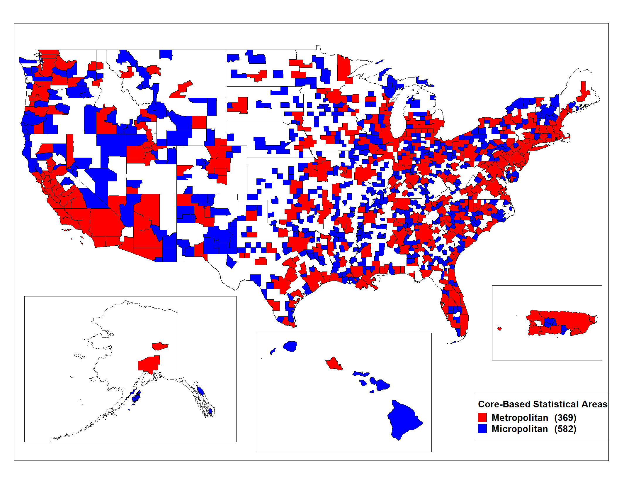
 The Micropolitan Statistical Areas are shown in blue on this enlargeable map of the Core Based Statistical Areas of the United States.
 See also: Table of United States Micropolitan Statistical Areas and Table of United States Core Based Statistical Areas
United States Micropolitan Statistical Areas (µSA, where the initial Greek letter mu represents "micro-"), as defined by the United States Office of Management and Budget, are urban areas in the United States based around a core city or town with a population of 10,000 to 49,999.[1] The micropolitan area designation was created in 2003. Like the better-known metropolitan area, a micropolitan area is a geographic entity used for statistical purposes based on counties and county-equivalents [1]. The OMB has identified 577 such areas in the nation.
The term "micropolitan" was created by author G. Scott Thomas for a 1989 article in American Demographics magazine, and was expanded in his 1990 book, The Rating Guide to Life in America's Small Cities.[2] It gained currency in the 1990s to describe growing population centers in the United States that are removed from larger cities, in some cases by 100 miles (160 km) or more. Lower land and labor costs have led some micropolitan areas to develop many housing subdivisions and suburban cultures similar to those found in larger metropolitan areas.
Micropolitan cities do not have the economic or political importance of large cities, but are nevertheless significant centers of population and production, drawing workers and shoppers from a wide local area. Because the designation is based on the core town's population and not on that of the whole area, some micropolitan areas are actually larger than some metropolitan areas. The largest of the areas, the one whose core city is Torrington, Connecticut, had a population in excess of 180,000 in 2000; Torrington's population in that year's census was only 35,202.
Many such areas have dynamic rates of growth; however, all micropolitan areas combined account for about 10% of the population.
See also
 United States census statistical areas by state, district, or territoryASMPGUVI
- Geography
- United States
- United States Census Bureau
- United States Office of Management and Budget
- Combined Statistical Area
- Core Based Statistical Area
- United States urban area
- Demographics of the United States
- Table of United States Combined Statistical Areas (CSA)
- Table of United States Core Based Statistical Areas (CBSA)
- Table of United States primary census statistical areas (PCSA)
- List of United States urban areas
Notes
- ^ a b Metropolitan and Micropolitan Statistical Areas, U.S. Census Bureau
- ^ G. Scott Thomas, "Micropolitan America," American Demographics 11(May 1989): 20-24.
External links
- Metropolitan and Micropolitan Statistical Areas, U.S. Census Bureau
- Official government document on statistical areas definitions
- Nasser, Haya El (June 27, 2004). "Small-town USA goes 'micropolitan'". USA Today. http://www.usatoday.com/money/economy/2004-06-27-rural_x.htm. Retrieved 2008-07-23.
- Nasser, Haya El (November 22, 2004). "For political trends, think micropolitan". USA Today. http://www.usatoday.com/news/washington/2004-11-22-micropolitan_x.htm?csp=22_tnt. Retrieved 2008-07-23.
- McCarthy, Michael J. (August 23, 2004). "Main Street America Gets a New Moniker". Real Estate Journal. http://www.realestatejournal.com/relocation/relocation/20040823-mccarthy.html. Retrieved 2008-07-23.
- Thomas, G. Scott (July 21, 2008). "Dreamtowns that offer refuge from big cities and congested suburbs". bizjournals. http://www.bizjournals.com/edit_special/68.html. Retrieved 2008-07-23.
Categories:- United States micropolitan areas
- Urban planning in the United States
- Urban studies and planning terminology

Wikimedia Foundation. 2010.