- Milecastle 22
-
Coordinates: 55°00′43″N 2°01′04″W / 55.012062°N 2.017702°W
Milecastle 22 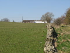
The site of Milecastle 22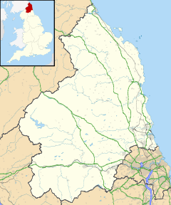
 Milecastle 22
 Milecastle 22 shown within Northumberland
OS grid reference NY98966861 List of places: UK • England • Northumberland 
This article is part of the series on:
Military of ancient Rome (portal)
753 BC – AD 476Structural history Roman army (unit types and ranks, legions, auxiliaries, generals) Roman navy (fleets, admirals) Campaign history Lists of wars and battles Decorations and punishments Technological history Military engineering (castra, siege engines, arches, roads) Political history Strategy and tactics Infantry tactics Frontiers and fortifications (limes, Hadrian's Wall) Milecastle 22 (Portgate) was a milecastle of the Roman Hadrian's Wall. Its remains exist as a low, turf covered platform just west of the Portgate roundabout (junction of the A68 and B6318). The platform is 0.5 metres (1.6 ft) on the east side, reducing to only a parch mark on the west side.[1]
Contents
Construction
Milecastle 22 was assumed to be a long-axis milecastle, and had Type III gateways (only the north gateway has been identified). Such milecastles were thought to have been constructed by the legio VI Victrix who were based in Eboracum (York).[2]
The milecastle was 16.76 metres (55.0 ft) across, but due to the location, the length of the other axis cannot be determined. It was constructed with Narrow Walls with a Standard B offset.[3]
Some time soon after construction of the milecastle, the north gateway was blocked by construction of a wall about 1 metre (3.3 ft) thick. It has been suggested that this is due to the proximity of the Portgate, rendering the milecastle redundant as a means of passage through the wall.
The curtain wall at this location was 3.05 metres (10.0 ft) wide.[3]
Excavations and investigations
- 1930 - Excavation showed that the side walls were 8 feet (2.4 m) thick, but the north Wall had the normal thickness (9 feet (2.7 m)). The internal width and the north gateway's type were also established. It was also discovered that the north gateway had been blocked.[4]
- 1966 - English Heritage Field Investigation. The location was confirmed. It was also noted that the remains consisted of a slight earthen platform, considerably spread by cultivation.[1]
- 1989 - English Heritage Field Investigation. It was noted that the milecastle survived as a squarish turf-covered platform, 0.5m high on the east side, but elsewhere as a parch mark only.[1]
Associated Turrets
Each milecastle on Hadrian's Wall had two associated turret structures. These turrets were positioned approximately one-third and two-thirds of a Roman mile to the west of the Milecastle, and would probably have been manned by part of the milecastle's garrison. The turrets associated with Milecastle 22 are known as Turret 22A and Turret 22B.
Situated between Milecastle 22 and Turret 22A is a structure known as the Portgate. This was a major gateway, allowing Dere Street to pass through the line of the Hadrian's Wall.
 The site of Turret 22A
Turret 22A
Turret 22A (Portgate) is (all but the south wall) buried beneath the Military Road. The south wall is under a fence immediately to the south of the road and does not project into the field. Excavation in 1930 releavled that the masonry was four courses high on the west side and three on the east.[5] The turret is of Standard A construction, indicating a change of builder since Milecastle 22.[3]
In 1850, a stone was found in the vicinity inscribed with the words Latin: "Fulgar divom" ("the lightning of the gods"). It is thought that this was set up where lightning had struck.
Location on Ordnance Survey 1:25 000 map: 55°00′47″N 2°01′31″W / 55.013139°N 2.025240°W
 The site of Turret 22B
Turret 22B
Turret 22B (Stanley) was located in 1930, alongside the Military Road, 10 yards (9.1 m) to the west of the lane leading to Portgate Farm.[4] There are no visible remains, the site being mainly covered by a modern road.[6]
The vallum around the area of Turret 22B was particularly well preserved, causing him to write [7]
“ I climbed over a stone wall to examine the wonder ... was fascinated, and unable to proceed; forgot I was on a wild common, a stranger, and the evening approaching ... lost in astonishment, I was not able to move at all. ” Location on Ordnance Survey 1:25 000 map: 55°00′51″N 2°01′59″W / 55.014081°N 2.033184°W
Monument Records
Monument Monument Number National Monuments Record Number Milecastle 22 18163 NY 96 NE 4 Turret 22A 18171 NY 96 NE 6 Turret 22B 18174 NY 96 NE 7 References
- ^ a b c "Milecastle 22". Pastscape. English Heritage. http://www.pastscape.org/hob.aspx?hob_id=18163. Retrieved 16 Aug 2010.
- ^ David J Breeze and Brian Dobson (1976). Hadrian's Wall. Allen Lane. pp. 14–15. ISBN 0140271821.
- ^ a b c d Breeze, David J (1934), Handbook to the Roman Wall (14th Revised edition - Nov 2006), Society of Antiquaries of Newcastle upon Tyne, pp. 184–185, ISBN 0901082651
- ^ a b Simpson, FG (1931). "Excavations on Hadrian's Wall between Heddon-on-the-Wall and North Tyne in 1930". Archaeologia Aeliana : or miscellaneous tracts relating to antiquity (Newcastle upon Tyne: The Society of Antiquaries of Newcastle upon Tyne) 8: 308, 317–319.
- ^ "Turret 22A". Pastscape. English Heritage. http://www.pastscape.org/hob.aspx?hob_id=18171. Retrieved 26 Aug 2010.
- ^ "Turret 22B". Pastscape. English Heritage. http://www.pastscape.org/hob.aspx?hob_id=18174. Retrieved 26 Aug 2010.
- ^ Hutton, William (1801). The History of the Roman Wall Which Crosses the Island of Britain From the German Ocean to the Irish Sea: Describing Its Antient State, and Its Appearance in the Year 1801. University of Michigan Library.
Bibliography
- Daniels, Charles (1979), "Review: Fact and Theory on Hadrian's Wall", Britannia 10: 357–364, JSTOR 526069
Milecastles of Hadrian's Wall Milecastles 0 • 1 • 2 • 3 • 4 • 5 • 6 • 7 • 8 • 9 • 10 • 11 • 12 • 13 • 14 • 15 • 16 • 17 • 18 • 19 • 20 • 21 • 22 • 23 • 24 • 25 • 26 • 27 • 28 • 29 • 30 • 31 • 32 • 33 • 34 • 35 • 36 • 37 • 38 • 39 • 40 • 41 • 42 • 43 • 44 • 45 • 46 • 47 • 48 • 49 • 50 • 50TW • 51 • 52 • 53 • 54 • 55 • 56 • 57 • 58 • 59 • 60 • 61 • 62 • 63 • 64 • 65 • 66 • 67 • 68 • 69 • 70 • 71 • 72 • 73 • 74 • 75 • 76 • 77 • 78 • 79 • 80
Milefortlets MF 1 • MF 2 • MF 3 • MF 4 • MF 5 • MF 6 • MF 7 • MF 8 • MF 9 • MF 10 • MF 11 • MF 12 • MF 13 • MF 14 • MF 15 • MF 16 • MF 17 • MF 18 • MF 19 • MF 20 • MF 21 • MF 22 • MF 23 • MF 24 • MF 25 • MF 26Other structures on Hadrian's Wall Portgate • Chesters Bridge • Knag Burn Gateway • Peel Gap Tower • Willowford Bridge • Pike Hill Signal TowerCategories:- Milecastles of Hadrian's Wall


Wikimedia Foundation. 2010.