- Ministry of Northern Development, Mines and Forestry
-
Ministry of Northern Development, Mines and Forestry (MNDMF) 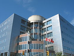
Ministry of Northern Development, Mines and Forestry head office in Sudbury. Agency overview Jurisdiction Ontario Headquarters 159 Cedar Street and 933 Ramsey Lake Road
Greater Sudbury, OntarioAgency executive Michael Gravelle, Minister of Northern Development, Mines and Forestry Parent agency Province of Ontario Website http://www.mndmf.gov.on.ca The Ministry of Northern Development, Mines and Forestry (MNDMF) is responsible for assisting economic development in the Northern Ontario region, and for mining and forestry regulation, in the Canadian province of Ontario.
The ministry's head office is located in Sudbury. The current Minister of Northern Development and Mines is the Honourable Michael Gravelle.
MNDM's programs also include the Northern Ontario Heritage Fund, and the creation and funding of local services boards to provide essential services in remote Northern Ontario communities which are not served by incorporated municipal governments.
History
- 1889 – An Act of British Parliament gives control of Northern Ontario to the Ontario government. The province sets policies to develop the region's natural resources.
- 1905 – The first cabinet minister from Northern Ontario, Sudbury's Frank Cochrane, is appointed. Cochrane serves as minister of the new Department of Lands, Forests and Mines until 1911.
- 1912 – The Department creates a Northern Development Branch to further support growth in the North. In 1926, this branch becomes the Department of Northern Development.
- 1930s – The Department of Northern Development merges with the Department of Highways. Its purpose: to build and maintain roads and bridges in Northern Ontario.
- 1970 – The government creates a new Department of Mines and Northern Affairs in response to northerners' concerns about the lack of access to provincial government information. Twenty-four Northern Affairs offices in the region bring the Ontario government to northerners. This department changes name and responsibilities throughout the 1970s and early 1980s due to government restructuring.
- 1985 – The government creates a new Ministry of Northern Affairs and Mines. Later that year, the name becomes the Ministry of Northern Development and Mines. The change emphasizes the province's commitment to greater social and economic development in the north.
- 1990 – The ministry headquarters are re-located to two new buildings in Sudbury.
- 2009 – The realignment of forestry from the Ministry of Natural Resources to the Ministry of Northern Development and Mines is announced reflecting the importance of forestry to many northern and rural communities. The renamed Ministry of Northern Development, Mines and Forestry now leads the business and economic aspects of forestry, including industrial strategy, forest sector competitiveness programs, softwood lumber and wood allocation, pricing and licensing.
External links
Categories:- Ontario government departments and agencies
- Mining ministries
- Politics of Northern Ontario
- Organizations based in Greater Sudbury
- Forestry ministries
- Ontario stubs

Wikimedia Foundation. 2010.