- Lower Clapton
-
Coordinates: 51°33′08″N 0°02′49″W / 51.55212°N 0.04704°W
Lower Clapton 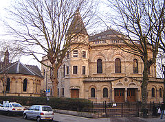
Lower Clapton's unusual Round Chapel. Built in 1869-71 as a Congregational church, it is now an arts centre. It is considered to be one of the finest non-conformist buildings in London.
 Lower Clapton
Lower Clapton shown within Greater LondonOS grid reference TQ355855 - Charing Cross 5 mi (8.0 km) SW London borough Hackney Ceremonial county Greater London Region London Country England Sovereign state United Kingdom Post town LONDON Postcode district E5 Dialling code 020 Police Metropolitan Fire London Ambulance London EU Parliament London UK Parliament Hackney South and Shoreditch London Assembly North East List of places: UK • England • London Lower Clapton is a district within the London Borough of Hackney.
It is immediately adjacent to central Hackney - bounded, roughly, by the western side of Hackney Downs (to the west), the Lea Valley (to the east), Clifden Road (to the south) and the Lea Bridge Road (to the north). Lower Clapton is centred on Lower Clapton Road, to the north of which is Clapton Pond, the remnant of the old village green.
Clapton Pond and the late Georgian Clapton Square are the area's two major conservation zones.
Hackney Downs, one of the larger open spaces in Hackney, is formally within this district, though many people consider the Downs to be an area of Hackney in its own right.
Like many other parts of East London, Lower Clapton is socially diverse and multicultural. Chatsworth Road, which had a regular market until the 1990s, still provides many amenities for people who live in the area. A new Sunday market has been established here since December 2010. The shops and restaurants on Chatsworth Road reflect the diversity of the surrounding streets - offering African, Turkish, Asian and Caribbean produce alongside butchers, bakers and greengrocers. More recent additions include a creperie, coffee shops and a French delicatessen, part of the area's vaunted gentrification in the lead up to the 2012 Olympic Games.
Lower Clapton has a relatively large amount of green space for a district of inner London. In addition to Hackney Downs, the area is bordered by Millfields Park, Clapton Park, and the recreational facilities of Hackney Marshes.
 Clapton Pond - the old village green. (September 2005)
Large parts of Lower Clapton look much as they did when the area was first developed in the second half of the 19th century. Most of the housing stock consists of Victorian terraces of various sizes. Several highrise LPS constructions erected by the Council in the late 1960s and early 1970s were demolished in the 1990s to make way for lowrise Local Authority housing, e.g. the Clapton Park Estate.
Notable residents have included John Howard, Nathaniel Woodard who was a curate of St. John's, Harold Pinter, Helen Shapiro and Jessica Tandy. Clapton F.C. were the original local football team, being formed in 1878.
A number of shootings experienced in the 1990s and early 2000s on Upper and Lower Clapton Road earned this stretch the nickname "Murder Mile".[1]
Contents
Education
For details of education in Lower Clapton, see List of schools in the London Borough of Hackney.Transport
- Nearby districts
The nearest London Overground stations are Homerton and Hackney Central
Neighbouring areas of London. 
Upper Clapton Lea Bridge Hackney Downs 
Hackney Marshes  Lower Clapton

Hackney Central Homerton References
- ^ Thompson, Tony (2001-04-22). "Two more die on 'murder mile'". The Guardian. http://www.guardian.co.uk/uk/2001/apr/22/tonythompson.theobserver1. Retrieved 2011-05-17.
External links
- The Round Chapel community centre
- Clapton from British History Online
- Clapton Pond Neighbourhood Action Group
Categories:- Districts of Hackney
- Districts of London


Wikimedia Foundation. 2010.