- Mission Hills, Los Angeles
-
For other places with the same name, see Mission Hills (disambiguation).
Mission Hills — Neighborhood of Los Angeles — Location within Los Angeles/San Fernando Valley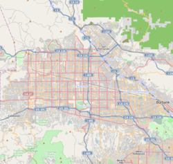
 Mission Hills
Coordinates: 34°15′26″N 118°28′02″W / 34.25722°N 118.46722°W Country United States State California County Los Angeles City Los Angeles Elevation 913 ft (278 m) Population (2000)[1] - Total 15,056 Time zone PST (UTC-8) - Summer (DST) PDT (UTC-7) ZIP code 91345 Area code(s) 818 Mission Hills is a suburban community in the San Fernando Valley region of the city of Los Angeles, California.
It is located near the northern junction of the Golden State Freeway (Interstate 5) and the San Diego Freeway (Interstate 405). The Ronald Reagan Freeway (SR 118) bisects the neighborhood. Mission Hills is the northern terminus of the lengthy Sepulveda Boulevard. Other major thoroughfares include San Fernando Mission Boulevard, Woodman Avenue, and Rinaldi, Brand, Chatsworth, Devonshire, and Lassen Streets. The boundaries are roughly Sepulveda Blvd and Interstate 405 to the west, Interstate 5 to the north and east, Van Nuys Boulevard to the southeast, and Lassen Street to the south. The Granada Hills district lies to the west, Sylmar to the north, the city of San Fernando to the northeast, Pacoima to the east, Arleta to the southeast, and Panorama City to the south. The southern portion of Mission Hills is also considered part of the Sepulveda district of Los Angeles.
The community is notable as the location of Mission San Fernando Rey de España. The Andrés Pico Adobe, the second oldest residence still standing in Los Angeles, is also here. The San Fernando Mission Cemetery is still actively used.
Previous Name – Dennis Park, CA
Contents
Demographics
In 2009, the Los Angeles Times's "Mapping L.A." project supplied these Mission Hills neighborhood statistics: population: 18,237; median household income: $75,675.[2]
Government and infrastructure
The Los Angeles County Department of Health Services operates the Pacoima Health Center in Pacoima, serving Mission Hills.[3]
Education
Residents are zoned to schools in the Los Angeles Unified School District.
Medical centers
Providence Holy Cross Medical Center is located within the community.
Government and infrastructure
The United States Postal Service operates the Mission Hills Post Office at 15305 Devonshire Street and the Mission City Post Office at 10919 Sepulveda Boulevard.[4][5]
Economy
Tourism
Tourists visit the Mission San Fernando Rey de España, a historical mission.
Notable natives
People who were born in Mission Hills:
- Ryan Braun (major league baseball All Star left fielder)
- Jessica Cosby (Olympic athlete; track and field)
- George Lopez (comedian)
References
- ^ "Los Angeles Almanac: City of Los Angeles Population by Community & Race 2000 Census". http://www.laalmanac.com/population/po24la.htm. Retrieved November 28, 2008.
- ^ "Mission Hills" entry on the Los Angeles Times "Mapping L.A." website
- ^ "Pacoima Health Center." Los Angeles County Department of Health Services. Retrieved on March 17, 2010.
- ^ "Post Office Location – MISSION HILLS." United States Postal Service. Retrieved on December 6, 2008.
- ^ "Post Office Location – MISSION CITY." United States Postal Service. Retrieved on December 6, 2008.
Coordinates: 34°15′26″N 118°28′02″W / 34.257222°N 118.467222°W
City of Los Angeles Topics History • Transportation • Culture • Landmarks • Historic sites • Skyscrapers • Demographics • Crime • Sports • Media • Music • Notable people • Lists
Government Flag • Mayors • City Council • Other elected officials • Airport • DWP • Fire Department • Police • Public schools • Libraries • Port • TransportationRegions Downtown • Eastside/Northeast • Harbor Area • Greater Hollywood • Westlake & Silver Lake/Los Feliz • San Fernando and Crescenta Valleys • South Los Angeles • Westside • WilshireLos Angeles city areas within the San Fernando and Crescenta Valleys Districts and
neighborhoodsArleta · Canoga Park · Chatsworth · Encino · Granada Hills · Lake View Terrace · Lake Balboa · Mission Hills · NoHo Arts District · North Hills · North Hollywood · Northridge · Pacoima · Panorama City · Porter Ranch · Reseda · Shadow Hills · Sherman Oaks · Studio City · Sun Valley · Sunland · Sylmar · Tarzana · Toluca Lake · Tujunga · Valley Village · Van Nuys · Ventura Business District · Warner Center · West Hills · Winnetka · Woodland Hills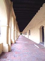
Points of
interestSee also Downtown · Eastside/Northeast · Harbor Area · Greater Hollywood · Westlake & Silver Lake/Los Feliz · San Fernando and Crescenta Valleys · South Los Angeles · Westside · Wilshire Categories:- Neighborhoods in Los Angeles, California
- Communities in the San Fernando Valley


Wikimedia Foundation. 2010.