- Strogino–Mitino extension
-
The Strogino Mitino extension also known as the Strogino-Mition Line (Russian: Строгинско-Митинская линия) is one of the largest projects that Moscow Metro is currently embarked upon in the lengthening of the system and to serve the North-western Moscow Districts of Strogino and Mitino.
Contents
Geography of the region
In 1961 the city of Moscow's area was nearly doubled by annexing adjacent territory from the Moscow Oblast. The new land was to be used to build large housing developments for the rapidly growing city. However the geometry of the new layout, which was punctuated by building the MKAD around the city-oblast border meant that future housing district of Strogino was geographically "sandwiched" by the new motorway to the east, the Serebryannyi Bor (Silver Pinewood) natural park to the south and the Moskva River to the north, thus making geographically isolated from the rest of Moscow. The territory for the future district of Mitino, which lies beyond the MKAD, was added to Moscow in the 1980s; although it was not surrounded by natural and artificial barriers to the extent Strogino was, it too faced the problem due to its distance from the center city and to the fact that it too was isolated by the Tushino island formed by the Moscow Canal. (See map to picture both descriptions.)
However none of these logistical problems stopped large-scale housing development in both districts. They did though create very large problems in integrating them into Moscow's transport system. The only access to them from central Moscow was via either the MKAD, the Volokolamsk Highway for Mitino or the Strogino Highway which was a secondary road that ran through the dense district of Tushino for Strogino. In both cases the roads would be extensively congested.
The first project - branch
The natural way to solve this problem was to introduce the Moscow Metro, which would be immune to geographical barriers and also provide high speed access to the residents. The first plans to link the new suburbs were formed back in the 1960s before they were even built, let alone settled. The mid-1960s general plan proposed the new Tagansko-Krasnopresnenskaya Line to have a branch from Polezhaevskaya which would continue westwards into Khoroshovo, Taman island and ultimately Strogino, and afterwards towards Krasnogorsk (Mitino was still to be annexed into Moscow and the general plan did not have any provisions for housing there) See map 1, 2.
Despite Polezhevskaya being opened in 1972 with three tracks, it was never to be used for its intended purposes. With more important projects being priority, the disagreements in bringing Metro to Strogino prevented from a detailed plan to be announced.
In 1979 the Kalininskaya Line was opened, planning its western radius, keeping true to the radial-diametral layout of Moscow, was not simple.[clarification needed] Throughout the 1980s there were proposals to link the line to Arbatskaya (Arbatsko-Pokrovskaya) and thus split the Arbatsko-Pokrovskaya Line by giving its eastern radius to the Filyovskaya Line (in a way restoring the pre-1953 operation) along with the name. Whilst the 1953 deep stations would pass onto the Kalininskaya Line, which after Kievskaya would have several options of which direction the radius would point, one of which was Solntsevo with a branch towards Ochakovo.
The second project - chord
As the first families began to settle the new apartments, Moscow Urban Rapid-Transit planning body - Metrogiprotrans was continuing to debate on not only a Metro to Strogino but about a complete and total change from the classical ring-radial layout of the metro. Owning to the disadvantages of the over-congested centre, initially in 1984 I.Burdakov published an article in Pravda where he proposed a set of chordial and semi-chordial lines that would bypass the city centre and the Koltsevaya Line, or at least have some of the transfers outside the ring, which applies to the latter group and the Lyublinskaya Line was a result of this.
For Strogino and Mitino this meant their Metro chord would be the end of a Stroginsko-Biryulyovskaya Line also later referred to as the Mitinsko-Butovskaya Line and it would begin in Mitino, continue south to Strogino and then to Khoroshovo, Fili, along the Moscow ring railroad via Luzhniki before finally coming south via the Serpukhovky and Zamoskvoretsky radii to the district of Biryulyovo before continuing into Butovo. map
As the chordial line, one of the four was to be the first, due to both Strogino, Mitino and Butovo being settled its construction was priority. In 1988 building commenced on Park Pobedy extension of APL which was to be a cross-platform transfer with the new chord, whilst the detail of the path via Strogino-Mitino was also announced, and construction was started in earnest on three stations: Strogino, Volokolamskaya and Mitino along with a new metro-bridge between Strogino and Volokolamskaya and a depot after Mitino.
The 1990s
Despite the grandeur of the chordial lines, they were not to be realised. In 1991 the Soviet Union collapsed; all state funding with the result of the financial crises was cut to negligible amounts. Construction of the started projects was permanently halted.
Moscow Metro was in crises moment; it could not afford the chordial line with the resources available, but by this moment Strogino and Mitino had become large urban districts. The neighbouring Krasnopresnensky radius, already heavily laden, became over-congested with the Strogino and Mitino commuters using land traffic to reach Metro via Tushinskaya, making it one of the busiest stations in the system, and the Tagansko-Krasnopresnenskaya Line becoming, not one of, but the busiest.
In March 1993, Moscow Metro published a revised plan for what was to replace the chord. The existing started section on the Mitino and Strogino should be completed and the hooked on to the Filyovskaya Line. That is how for the next ten years, all Moscow metro maps drew the three stations. However realistically, with the exception of the new Krylatskoye station (opened in 1989) and the underground Molodyozhnaya (1965), the Filyovskaya Line could not have dealt with the additional passenger load that would beset on it from Strogino and Mitino.
The same plan however also proposed that the Kalininskaya Line instead of its intended proposal to break up the Arbatsko-Pokrovskaya Line would now travel via Kropotkinskaya, both Smolenskayas, Moscow City and then onto Khroshovo, and along the original 1970s branch path into Strogino, before travelling on the 1980s path into Mitino.
The plan also in perspective proposed that Park Pobedy of the Arbatsko-Pokrovskaya Line would be completed and the line would then continue to double the Filyovskaya Line, with two stations before docking at Kuntsevskaya and annexing the underground section of the Filyovskaya Line.
However the financial crises meant that even this much simpler plan would not be realised. Moreover several questions were left hanging including how to actually pass the natural barriers that isolate the Strogino and Mitino from Moscow.
The Breakthrough
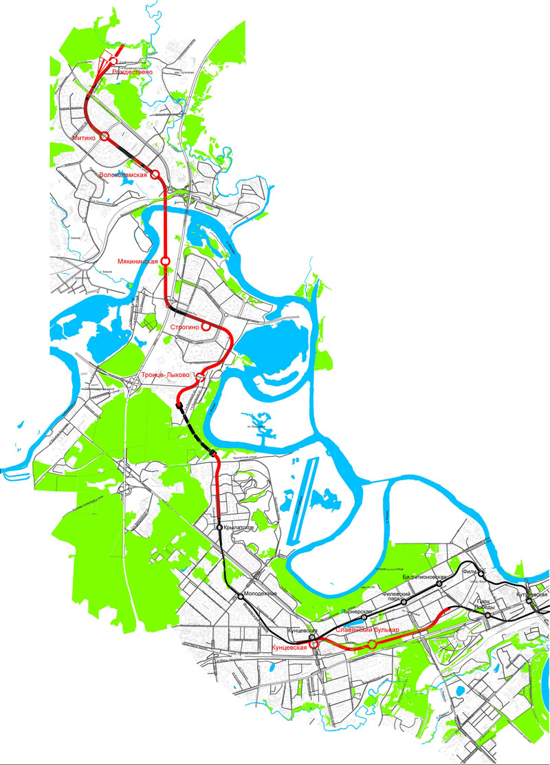
 The final Strogino-Mitino extension plan, as of 2002 black indicate sections built in the early 1990s
In the early 2000s the financial situation has slowly improved and as Moscow's population continued to rise, the change for infrastructure became evident. At the turn of the century, Moscow has announced a new project that would unite few of the older ones. To deal with the increasing car congestion, a new radial highway was required to relieve the city centre. Thus the Krasnopresnensky Prospekt was born, to link the existing Krasnaya Presnya street near the centre with the M9 Baltiya that ends at the MKAD. That was easier said than done, as this required first to build a long flyover over the industrial zone separating Presnya district from Khoroshovo, and then again conquering the Serebryannyi Bor natural barrier, as well as the Moskva River. In the end it was decided to first travel southwards along a new Zhivopisny Bridge to Krylatskoye and then to pass under the Serebryannyi Bor via a tunnel.
This tunnel was the "light in the tunnel" for finally bringing a Metro to Strogino, and it was planned as a combined auto and Metro one. Simultaneously the 1990s plan for the Strogino-Mitino extension was revived. Park Pobedy was finished and opened in May 2003.
The new project though similar added several corrections to the 1990s plan. The initial Park Pobedy-Kuntsevskaya called for two stations: Minskaya and Slavyansky Bulvar, however given that the former's role in serving residents was unimportant as it was located on the western end of the Victory Park near the Memorial Mosque it was omitted , and the route was re-traced, causing Slavyansky Bulvar to appear closer to the residential zones of Ochakovo and also allowing a transfer to the elektrichka of the Railway (Kiev direction).
Also reconsidered was the plan at the junction with Kuntsevskaya as initially it was proposed to simply cut off the Filyovskaya Line at Pionerskaya, however under local pressure, Moscow Metro reconsidered this and instead opted for a cross-platform transfer.
Also revised was the actual line to Strogino, which now due to the bend caused by the combined tunnel would emerge directly south of the district and facing north would be perpendicular to the station pit of the early 1990s construction site. The resulting contour to join up with the started sections called for a new station Troitse-Lykovo, as the region now planned a new housing massif in the revised general plan.
The original project for Strogino, which was to be a two-storied station was abandoned in favour of a single-vault with a provision to build a neighbour when and if the Kalininskaya Line finally reaches Strogino. The path onto Mitino also introduced a new station - Myakinino, which is to become the first station on the territory of the Moscow Oblast, and right next to the province's administration office, and governor's residence. After the crossing of the river Moskva on the Metro-bridge, the project for Volokolamskaya was also revised, and part of it included a new combined transfer point to a relocated station on the Riga-direction railway - Trikotozhnaya. Finally the Mitino path also introduced a new station next to the future depot - Rozhdestveno.
Thus in all the total length of the new extension was approximately 20 kilometres (4.9 for Park Pobedy-Kuntsevskaya and the remaining for Krylatskoye-Rozhdestveno).
Progress
Stations
- Park Pobedy - Opened 5 March 2003.
- Slavyansky Bulvar - Opened 7 September, 2008.
- Kuntsevskaya - Opened 7 January, 2008.
- Molodyozhnaya — Annexed from Filyovskaya Line 7 January, 2008.
- Krylatskoye — Annexed from Filyovskaya Line 7 January, 2008.
- Troitse-Lykovo - Provisional station, will not open until 2015.
- Strogino - Opened 7 January, 2008.
- Myakinino — Opened 26 December, 2009.
- Volokolamskaya — Opened 26 December, 2009.
- Mitino — Opened 26 December, 2009.
- Rozhdestveno — Construction yet to begin, expected to open circa 2011.
Other Objects
Directly related to the project:
- Krasnopresnensky Prospekt tunnel opened 27 December 2007
- Myakininsky Metro-bridge — opened 26 December, 2009.
- Mitino Depot — Construction yet to begin, expected to open circa 2011.
Categories:
Wikimedia Foundation. 2010.