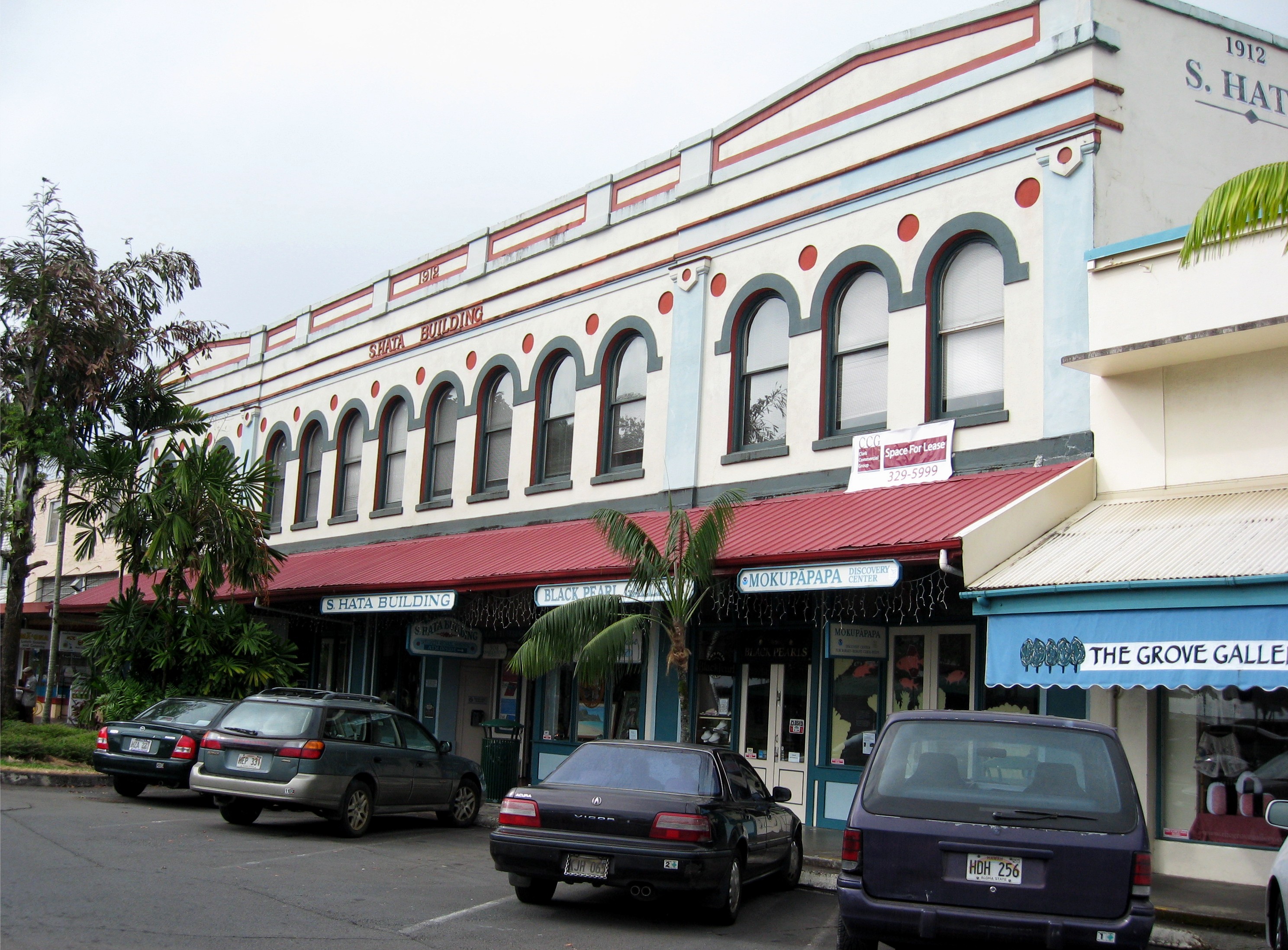
- S. Hata Building
-
Sadanosuke Hata Born 1868
Hiroshima, JapanDied Hilo, Hawaii Nationality Japanese American Occupation Businessman Spouse Masae Shindo Children 1 son, 4 daughters (Tamotsu +?) S. Hata Building Built for Sadanosuke Hata

Location: 308 Kamehameha Avenue, Hilo, Hawaii Coordinates: 19°43′25″N 155°5′5″W / 19.72361°N 155.08472°WCoordinates: 19°43′25″N 155°5′5″W / 19.72361°N 155.08472°W Built: 1912 Architect: William C. Furer Architectural style: Early Commercial Governing body: Private NRHP Reference#: 91001087[1] Added to NRHP: August 27, 1991 Yoichi Hata Born 1884
Hiroshima, JapanDied Honolulu, Hawaii Nationality Japanese American Occupation Businessman Spouse Naeko Hirata Children Yukiko, Minoru, Susumu, Akira, Yoshimi, Frank J +? Sadanosuke Hata (1868 - ?) was a Japanese businessman who built a historic structure called the S. Hata Building in Hilo, Hawaii, in 1912. It now contains specialty shops, professional offices, a restaurant, and the Mokupāpapa Discovery Center, a visitors center for the Northwestern Hawaiian Islands. Sadanosuke's younger brother Yoichi Hata (1884 - ?) was another notable Japanese businessman who founded a major wholesale food distribution company in Hawaii.
Contents
Hata family
Sadanosuke Hata was born in Hiroshima, Japan in 1868 and immigrated to Honolulu, Hawaii in 1891.[2] In 1893, Mr. Hata worked as an agent for Odo Shoten in Honolulu (shoten means "store" in the Japanese language), responsible for taking orders from large sugar plantations on the Hāmākua coast which employed many Japanese immigrant workers.[3] This gave him the inspiration to start his own business at Hilo on the Big Island of Hawaii on January 3, 1896 called S. Hata Shoten, Limited. He sold Japanese silks, kimonos, as well as oriental souvenirs and provisions. Business was slow in the first years, so he hired out his horse and hackney carriage as a taxicab for visitors.[4]
After the annexation by the United States to become the Territory of Hawaii in 1898, the plantations flourished, as did his business. He moved to a larger building at the corner of Mamo and Keawe streets. He branched out back to Honolulu and Hiroshima, Osaka, Japan, Kyoto, Japan, and Yokohama, Japan.[4]
Yoichi Hata, Sadanosuke's younger brother (born 1884) also arrived in Hilo and worked as bookkeeper at S. Hata Shoten. The business was so prosperous in 1912 that it needed more space. The previous building became a wholesale food distributing outlet ran by Yoichi Hata. Sadanosuke planned a new $25,000 structure on wetlands on Front Street (later renamed Kamehameha Avenue) near the railroad tracks to the plantations. A condition of the United States government's selling this land was that Mr. Hata erect a concrete building within a year's time.[5]
Building
At the time it was built, almost all other structures in Hawaii outside of Honolulu were built of wood. The building is about 109 feet (33 m) by 60 feet (18 m) of reinforced concrete. Such a large masonry building indicated the upward mobility of the Japanese population. The Hilo Masonic Lodge, Hilo Federal Building and Volcano Block Building are the others from that period that remain. The first floor has several store-fronts. A wooden staircase leads to a second floor of office space, with 14 arched windows. In 1913 he opened the Hilo Sake Brewing Company.[6] In 1919 two wood structures were added to the back, one commercial and one residential.[5]
After the attack on Pearl Harbor the Hata family was part of the Japanese American internment.[7] In September 1942 (during World War II) the Hata Building was seized and later auctioned by the United States government.[8][9] </ref> Hata's second daughter, Mrs. Kasujiro Kagawa, purchased the building at that time.[5] Because it was so solidly built, it survived the tsunami caused by the April 1, 1946 Aleutian Islands earthquake that devastated much of Hilo. The train tracks of the Hawaii Consolidated Railway were destroyed in that tsunami, so the building now is on the commercial street nearest the ocean.[10] The path of the railroad was used for the new Hawaii Belt Road (state route 19), called the Waterfront Highway at this point.
The 18,650-square-foot (1,733 m2) building originally had a full basement, but it was filled in following another major tsunami from the 1960 Valdivia earthquake. Its condition deteriorated and by 1990 it was scheduled to be demolished. David Levenson bought the property from Hata's descendants, renovated the interior while restoring the exterior, and rented it to a number of local businesses.[11] The metal awning between the two stories was replaced, but the wrought iron brackets were restored. It is located at 308 Kamehameha Avenue, coordinates 19°43′25″N 155°5′5″W / 19.72361°N 155.08472°WCoordinates: 19°43′25″N 155°5′5″W / 19.72361°N 155.08472°W.
The Hilo Farmers Market was started on this block in 1988, held every Wednesday and Saturday at the end of Mamo Street.[12] The building was listed as state historic site 10-35-7420 on January 14, 1989[13] and added to the National Register of Historic Places listings on the island of Hawaii on August 27, 1991 as site 91001087.[1] The family formed the Sadanosuke Hata Charitable Foundation in 1999 which supports the Japanese Cultural Center of Hawaii in Honolulu.[14] In 2003 the building was sold to the Takeyama family.[15]
Yoichi Hata
Yoichi Hata married Naeko Hirata in 1905, and they had 8 sons and 1 daughter.[2] These include Susumu (1917–2003), Yukiko (1918–2000), Minoru, Akira, Yoshimi, Frank J. and others.[16] He became a director of the newly formed Peoples Bank of Hilo on September 1, 1916.[17] The Y. Hata company was incorporated as a separate entity in 1922, and is still run by a descendant. Branches were opened in Osaka in 1936 and Honolulu in 1937. After the 1960 tsunami, the original wholesale building on Ponahawai Street was abandoned, and offices were moved to a new industrial area, 300 Kanoelehua Avenue in Hilo, and 285 Sand Island Road in Honolulu. In addition to food distribution to markets across the Hawaiian islands, restaurant supplies and chef services are now offered. They are also the major supplier to the U.S. military in Hawaii.[18] Yoichi's son Minoru was CEO from the 1960s until the late 90s and then Yoichi's son Frank was chairman until 2008, and Frank's son Russell Hata took over in May, 2008.[19]
 An exhibit at the discovery center
Mokupāpapa Discovery center
In May 2003, the Mokupāpapa Discovery Center opened in the restored S. Hata building.[20] It displays educational interactive exhibits on the Northwestern Hawaiian Islands, which are protected along with their surrounding waters as the Papahānaumokuākea Marine National Monument.[21] The name comes from Moku pāpapa in the Hawaiian language which means "flat reef island". This name was used in chants of Ancient Hawaii, perhaps referring to the area now known as French Frigate Shoals, or the northwestern islands in general.[22] The Northwestern islands stretch for hundreds of miles northwest of the main Hawaiian islands; ironically, the discovery center is on the southeastern-most island in the chain, the farthest one away from the reserve.[22]
A 2,500-US-gallon (9,500 l) salt-water aquarium displays some of the fish of the reefs. A mock-up of the control panel of Hawaii Undersea Research Laboratory's exploration submersible, the Pisces V, allows visitors to use working robot arms. One entire wall is covered by a large mural painted by local artist Layne Luna depicting the coral reef. Several life-sized models of fish and manta rays hang from the ceiling. Another exhibit plays a recording of the creation chant of Hawaiian mythology known as Kumulipo. Signs are in the Hawaiian language and English.
Public educational meetings are often held in the meeting room, such as those of the Pacific American Foundation.[23] Admission to the 4,000-square-foot (370 m2) center is free although donations are accepted. It is open Tuesday through Saturday 9AM to 4PM, closed holidays.[20]
References
- ^ a b "National Register Information System". National Register of Historic Places. National Park Service. 2009-03-13. http://nrhp.focus.nps.gov/natreg/docs/All_Data.html.
- ^ a b Curtis Narimatsu (July 26, 2009). "Dispatches by Curt". Big Island Chronicle. http://www.bigislandchronicle.com. Retrieved 2009-07-20.
- ^ Philip K. Barnes (1999). A Concise History of the Hawaiian Islands. Petroglyph Press, Hilo. p. 40. ISBN 0-912180-56-0.
- ^ a b Yukino Tsuzaki (February 17, 1935). "Sadanosuke Hata is Hilo's Oldest Japanese Merchant". collection of Wayne Subica at Hawaii Plantation & Industrial Museum archives (Hawaii Tribune-Herald).
- ^ a b c Kirk Soares (November 29, 1988). "S. Hata Building Nomination form". National Register of Historic Places. National Park Service. http://pdfhost.focus.nps.gov/docs/NRHP/Text/91001087.pdf. Retrieved 2009-07-20.
- ^ Ice and Refrigeration. 45. Southern Ice Exchange. 1913. p. 373. http://books.google.com/books?id=NRcpAAAAYAAJ&dq=hilo%20sake%20brewery&pg=RA1-PA373.
- ^ "Hata Yoichi". George Hoshida Collection. Japanese American National Museum. http://www.janm.org/collections/item/97.106.2S/. Retrieved 2009-07-22.
- ^ Jean Rondot, Alien Property Custodian (1942). Annual Report of the Office of Alien Property. p. 195. http://books.google.com/books?id=6c_sZ0m6eacC&lpg=RA3-PA182&vq=hata&pg=RA1-PA195.
- ^ "Custodian Seizes Japanese Holdings; Interests in Thirty Companies Are Taken Over". New York Times archives. September 3, 1942. http://select.nytimes.com/gst/abstract.html?res=FA081EFB3558167B93C1A91782D85F468485F9.
- ^ Robert Oaks (2003). Hawai'i:A history of the Big Island. Arcadia Publishing. p. 84. ISBN 978-0738524368. http://books.google.com/books?id=dtSwba95elEC&l&pg=PA85.
- ^ Kevin Dayton (May 7, 2003). "Historic S. Hata Building in Hilo for sale". Honolulu Advertiser. http://the.honoluluadvertiser.com/article/2003/May/07/bz/bz04a.html. Retrieved 2009-07-22.
- ^ "Map and Directions". Hilo Farmers Market web site. http://www.hilofarmersmarket.com/map.html. Retrieved 2009-07-22.
- ^ Historic Places in Hawaii County on official state web site
- ^ "Sadanosuke Hata Charitable Foundation form 990". Foundation Center web site. 2008. http://dynamodata.fdncenter.org/990pf_pdf_archive/990/990341146/990341146_200712_990PF.pdf. Retrieved 2009-07-20.
- ^ "Property Tax Record for 308 Kamehameha Avenue". County of Hawaii. http://www.hawaiipropertytax.com/Search/GenericSearch.aspx?mode=ADDRESS.
- ^ "Obituaries". Honolulu Star-Bulletin. July 8, 2003. http://archives.starbulletin.com/2003/07/08/news/obits.html. Retrieved 2009-07-22.
- ^ "Peoples Bank of Hilo, Ltd". Bankers magazine (Bankers Publishing Company) 100: p. 941. January–June 1920. http://books.google.com/books?id=zGc9AAAAYAAJ&pg=PA941.
- ^ "About Us". Y. Hata & Company, Limited official web site. http://www.yhata.com/main.html.
- ^ "Y. Hata names interim CEO and president". Pacific Business News. May 9, 2008. http://pacific.bizjournals.com/pacific/stories/2008/05/05/daily73.html. Retrieved 2009-07-18.
- ^ a b "Mokupāpapa: Discovery Center". Northwestern Hawaiian Islands Coral Reef Ecosystem Reserve. http://www.hawaiireef.noaa.gov/education/center.html. Retrieved 2009-09-13.
- ^ "Papahānaumokuākea Marine National Monument". official web site, National Oceanic and Atmospheric Administration. http://www.hawaiireef.noaa.gov/. Retrieved 2009-09-13.
- ^ a b Larry L. Kimura (1998). Juvik and Juvik. ed. Atlas of Hawaii. University of Hawaii Press. p. 27. ISBN 978-0824821258.
- ^ "Aloha ʻAina (love the land)". Pacific American Foundation web site. 2009. http://alohaaina.thepaf.org/. Retrieved 2009-09-13.
External links
U.S. National Register of Historic Places Topics Lists by states Alabama • Alaska • Arizona • Arkansas • California • Colorado • Connecticut • Delaware • Florida • Georgia • Hawaii • Idaho • Illinois • Indiana • Iowa • Kansas • Kentucky • Louisiana • Maine • Maryland • Massachusetts • Michigan • Minnesota • Mississippi • Missouri • Montana • Nebraska • Nevada • New Hampshire • New Jersey • New Mexico • New York • North Carolina • North Dakota • Ohio • Oklahoma • Oregon • Pennsylvania • Rhode Island • South Carolina • South Dakota • Tennessee • Texas • Utah • Vermont • Virginia • Washington • West Virginia • Wisconsin • WyomingLists by territories Lists by associated states Other Categories:- Buildings and structures on the National Register of Historic Places in Hawaii
- 1912 architecture
- Hawaii culture
- Natural history museums in Hawaii
- Museums in Hilo, Hawaii
- American people of Japanese descent
- Businesspeople from Hawaii
- Retail buildings in the United States
- Commercial buildings in Hawaii


Wikimedia Foundation. 2010.