- Moneton people
-
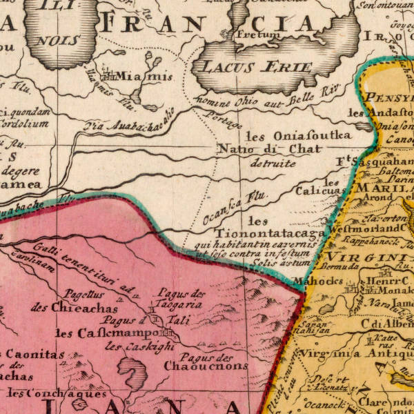
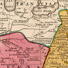 Clip from Homann Johann Baptist 1663-1724 map ca 1710 showing the people Captain Vielle, in 1692, passed by to arrive in Chaouenon's country as the French Jesuit called the Shawnee.
The Moneton people were a historical Native American tribe from West Virginia'. In the late 17th century, they lived in the Kanawha Valley, near the Kanawha and New Rivers.[1]
Contents
Name
What the Monetons called themselves is unknown. In the 1670s, Abraham Wood wrote their name "Moneton" and the other variant "Monyton."
This era was a century before Chickamauga Wars. Points from the Blue Ridge Mountains and Shenandoah River tributary outcrops have been found near Beckley, West Virginia. The eastern slopes of the southern Allegheny Mountains in today's Virginia is traditionally the Mahock,[2] and western rim of Tutelo and "Monasuccapanough" (1607) Siouan language groups and those of Iroquois dialects. The Monacan, "Monahassanaugh" (1607).
Kahnawáʼkye in Tuscarora (Iroquois) means "waterway", "kye" is augmentive suffix. Kaniatarowanenneh means "big waterway" in Mohawk (Iroquois).[citation needed]
Language
Swanton guessed that the Moneton language was Siouan.[3]
History
James Mooney declared the Moneton lived in the western part of Colonial Virginia and said their name was an eastern Siouan word.[citation needed] Some scholars suggest Monetons were an element of Monacan and a variation of colonial spelling. The phrase Wood writes can be understood a couple of ways and having no surety.
Wood's remarks imply that some of the [sic]"Tomahittons" favored the [sic]"Occheneechees" position in Virginia's Fur Trade as middlemen. A small group of Tomahitans tied Arthur, Wood's agent, to the stake to burn him under the instructions of the "Occheneechees". The King of "Tomahittons" arrived, in time, and rescued Arthur, shooting that sub-group's leader. This seems to have put a quick end to the political dispute within the Tomahitan tribe. The Tomahitan tribe did accept members of certain other tribes to live with them as subordinates. Wood's recount of Arthur's travels does yield the Moneton neighbor's of 3 days journey or about 60~90 miles away and much further away if by canoe. This distance is based on the well known explorier surveyors Christopher Gist's and George Washington's several journals ability to travel these regions. The Moneton neighbor's shot arrows at Tomahitans on sight, but did not bother themselves to give chase. Alas, this still does not achieve the question, who were the Moneton's?
Gabriel Arthur's visit
 The Andaste spoke an Iroquois dialect and were fort builders. They were allies with the Huron Confederacy. An Andaste site is located in the Eastern Panhandle at Moorefield, West Virginia. See Captain John Smith article, 1612 map.
From a letter dated August 22, 1674 of Abraham Wood to John Richards: "Now ye king (Tomahitans) must goe to give ye monetons a visit which were his frends, mony signifing water and ton great in theire language Gabriell must goe along with him They gett forth with sixty men and travelled tenn days due north and then arrived at ye monyton towne sittuated upon a very great river att which place ye tide ebbs and flowes.[4] Gabriell swom in ye river severall times, being fresh water, this is a great towne and a great number of Indians belong unto it, and in ye same river Mr. Batt and Fallam were upon the head of it as you read in one of my first jornalls. This river runes north west and out of ye westerly side of it goeth another very great river about a days journey lower where the inhabitance are an inumarable company of Indians, as the monytons told my man which is twenty dayes journey from one end to ye other of ye inhabitance, and all these are at warr with the Tomahitans. when they had taken theire leave of ye monytons they marched three days out of thire way to give a clap to some of that great nation, where they fell on with great courage and were as curagiously repullsed by theire enimise," wrote Abraham Wood.[5]
The First Explorations of the Trans-Alleghany Region by the Virginians 1650–1674
"The word Monetons, according to Mooney (letter of January 7, 1909) is Siouan. The identity of the tribe is doubtful. From location and similarity of name they may perhaps be simply the Mohetan of Fallam's journal, and belong to the Cherokee. The Mohetan told Batts and Fallam that their villages were about half-way between Peters' Mountain and the Ohio."— Clarence Walworth Alvord and Lee Bidgood, 1912. Hale & Mooney defines Siouan "Mon", "Ma" and "Man" meaning a people's land otherwise their "country" which by this definition "Mon" does not directly refer to "water", but, to the "area of". Some scholars have pointed out that unlike the other proper nouns, Wood does not capitalize in his printing "monetons" nor the variant, "monytons", another curious observation. "Mone" means water, and "ton" means large according to Robert Rankin, professor emeritus of linguistics at the University of Kansas, Siouan linguistics.[6] Doctor Rankin compared linguistically "the Tutelo of Virginia are more closely related to the Crows of Montana than the Catawbans (of Carolinas)". From very recent study of 9,000 pottery shards from Fort Ancient sites in the Kanawha and Ohio River valleys showed that 37 percent of them bore corncob impressions similar to those produced in the Siouan villages of Virginia between 1400 and 1600 as Charleston Gazette staff writer Rick Steelhammer summarized Darla Spencer of Cultural Resources Analysts, Inc results. "I think Siouan was spoken in the Kanawha Valley," Doctor Rankin concluded at the 2009 WV Archaeology Annual Meeting.
Using topographic maps, geographic landmarks and travel distances, Briceland (1987)[7] demonstrates that Batts & Fallam reached Matewan on the Tug Fork. There are no known, else discovered, archaeological village sites on this branch. However, using the same method, the local university discussions point to the Guyandotte at the Logan County archaeological village site being Batts & Fallam's farthest reach in exploration. The islands near Logan resembles the falls of the James River near Wood's Fort in Virginia. The gravel bar near Matewan, West Virginia does not resemble these early descriptions of the village's location of Batts & Fallam. These studies, also, are speculation yet to be proven.
Other of ye inhabitance
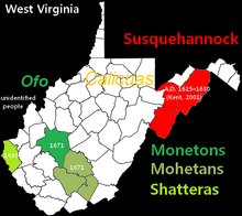 Locations in WV of Shatteras, Monetons, Mohetans and Susquehannocks archeological sites. (Brashler 1987)(Kent 2001)
Of the unidentified people on the Ohio Valley, Wood writes, "He (Gabriell) made signes to them the gun was ye Tomahittons which he had a disire to take with him, but ye knife and hatchet he gave to ye king. they not knowing ye use of gunns, the king received it with great shewes of thankfullness for they had not any manner of iron instrument that hee saw amongst them ". The reports of this tribe given by the Mohetan to Batts and Fallam correspond with those given to Arthur by the Moneton. Fallam called those on the Great Kanawha River "Mohetan" and this is perhaps an example of tribal influx. In 1671, Thomas Batts wrote, "We understand the Mohecan Indians did here formerly live. It cannot be long since we found corn stalks in the ground." Batts and Fallam, Wood's agents, are credited as having discovered Kanawha Falls. Ouabano was a band of Mohicans or Eastern Lenape who lived within the region (Hodge). Mr Batts wrote about what he saw. Earlier scholars have this site as found to be on Campbells Creek near Belle.[8] Continued best guess otherwise, there is the archaeological village site at Marmet which is more likely Gabriel Arthur's visit with the Moneton (Maslowski et al.) and very near Belle.
The Iroquois League, Huron Confederacy and Andaste (Sultzman) are well reported as blocking the Nation du Chat from attaining fire arms, the Andaste serving as middlemen to the French and Dutch trade. The Dutch had provided Andaste with fire arms, another of the League's enemy who also spoke a dialect of Iroquois as did the "Panther People" (corrupted Nation du Chat) otherwise of the Iroquian word "Erielhonan".[9][10] Their neighbor east, at that time, of the Allegheny Mountains were the late Conestoga (Quaker for Andaste), earlier called Susquehannocks (Virginian). Susquehannocks is first mentioned in the Voyages of Samuel Champlain for 1615 as he calls one of their some 20 villages "Carantouan". It rallied more than 800 warriors with two other villages, Champlain reports. "Carantouan" was nearer to the New York and Pennsylvania border on the tributaries of the Susquehanna River on his map approaching towards the region from the Saint Lawrence Seaway.[11] West Virginia's Grant, Hampshire and Hardy counties and Maryland's Allegheny county region (Brashler 1987) possess archaeological sites having Susquehannock Ceramics. A Susquehanna site is located at Moorefield, West Virginia.
The tribes on the south eastern Allegheny Mountains of West Virginia in a region of the Blue Stone and Greenbrier river tributaries can be found in Batts and Fallows' September, 1671 Expedition. Penecute, an "Apomatack" Indian with seven more additional escorts who were later sent by their leadership, was hired and later a "Sepiny" Indian guide of the Sapony River (Staunton River) was hired to trek towards the "Teteras" (Toteras.) September 12, 1671, a Teteras guide was hired from a village just west of today's Salem, Virginia. It was declared while on the New River at Peters’ Falls, where the New River breaks through Peters’ Mountain, near Pearisburg, Virginia the "Moketans had formerly lived." On the valleys near today's Lewisburg and Beckley of the West Virginia area, "One came ("Apomatack" excort) and told us they heard a Drum and a Gun go off to the northwards..." and some days later they learnt the "Mountain Indians" of the Kanawha Falls ("Walnut Gather Place") area already possessed firearms, "...We have found Mehetan Indians who having intelligence of our coming were afraid it had been to fight them and had sent him to the Totera’s to inquire. We have him satisfaction to the contrary and that we came as friends, presented him with three or four shots of powder. He told us by our Interpreter, that we had [been] from the mountains half way to the place they now live at. That the next town beyond them lived on a plain level, from whence came abundance of salt. That he could inform us no further by reason that there were a great company of Indians that lived upon the great Water."[12] It can be surmised these were the arrival of the Les Tionontatacaga or Guyandotte of which namesake is the Guyandotte River in Cabell County. This journal does not identify the "Salt Village" on the Kanawha, but, that the "Mehetan" were associated with these and apparently not those further down to the Ohio River.
Protohistory
 Augustin Herrman printed the Sussquahana and Sinaicus Indians went over to the Black Mincquaas' River and destroyed that Nation, a contemporary telling of trade, mountain's weather and Iroquois nation building, 1670.
 Clip from 1671 French map
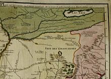 Guyandottes appear in the region after the Siouan occupation, 1715 Nicolas de Fer
"Les Tionontatacaga" (Guyandottes), shown on Homann Johann Baptist's map of 1710, had taken refuge farther in West Virginia's hollows (after 1701) from the great heat of the Iroquois invasion, the Moneton's territory.[13] "Les Oniassoutlea", dialect variation Oniassontke, shown on the map are otherwise Black Minqua (Dutch) of the Upper Ohio Valley and Honniasontkeronon of the Middle Ohio Valley. Honniasontkeronon "infested the country above the rapids of the Ohio River" as the Seneca told La Salle in 1669. They were reported to be hereditary enemies to the Nation of Fire.[14] The Shattera's (Swanton's Toteras element of Tutelo) village is shown at Williamson (Tug Fork) according to a letter written to the Lord of Trade, New York, dated April 13, 1699. E.B. O'Callaghan M.D. also cited this source in his "Colonial History of the State of New York", published at Albany in 1856. There is uncertainty as which stream they migrated at first to near Salem, Virginia, either their Big Sandy (or the Logan site) or the Great Kanawha rivers.[15] The Big Sandy River, a border of West Virginia and Kentucky, was once known as the "Toteroy River" in their memory as shown on early maps.
Anthropologist James B. Griffin in 1942 concluded, "there is not…any sound historical evidence for believing that the central Ohio Valley was the point of dispersal for the Siouan speaking tribes." Griffin's book On the Historic Location of the Tutelo and the Mohetan in the Ohio Valley is devoted in greater part to the Tutelo.[16] Griffin devotes one paragraph of the Mohetan's east-to-west movement within the area and one sentence about Mosopolea occupation on the Ohio Valley.[17] James Mooney, in a monograph surveying “The Siouan Tribes of the East”, lists Mohetan as one of at least nine groups clearly Siouan. The Occaneechis (Akenatzy, etc.) language was said to be much like Tutelo and a lingua franca or a Virginia trade language. Tutelos and Saponis spoke virtually the same language. The Monyton's language is thought to be similar to Occaneechis while mąnį΄ ‘water’ in Tutelo; anį΄ in Ofo & Biloxi. ithą΄ ‘big, great’ in Tutelo; same in Ofo/Biloxi (Rankin 2009).
Western Virginia "Cherokee" (contemporary "Calicuas") were reported at Cherokee Falls[18] (today's Valley Falls) in 1705.[19] Indian trader Charles Poke's trading post dates from 1731 with the remanent Calicuas of Cherokee Falls still in the region from the previous century. "The Monetons are regarded to have been a distant branch of the Cherokees (contemporary "Tomahittons"). They had a natural antipathy for the Shawnees (contemporary "Showanoes"[20]), who were located on both sides of the Ohio in the vicinity of the mouth of the Scioto River. After terminating their visit with the Monetons the Cherokees went out of their direct path of return for a few days' swing to the westward to take a "clap" at their ancient and formidable enemy, the Shawnees.", quoting the Kentucky Historical Society (1922).[21]
In his book, "History Of The Commonwealth Of Pennsylvania", (Harrisburg, 1876) state librarian of Pennsylvania, William H. Egle figured that the Massawomeke is the tribe later known by the name of "Mohawk". Much earlier, however, Captain Henry Fleet arrived on the Potomac River after 1623. Later, William Claiborne, Sir John Wolstenholme, Clobery & Company and the Baltimores established a trading post at Kent Island (1631) on the upper Chesapeake Bay. They hired Fleet familiar with "Anacostia Valley Naturalls" as a guide and interpreter. Leonard Calvert's letter to Sir Richard Lechford, dated May 30, 1634, "The nation we trade withal at this time a-year is called the Massawomeckes. This nation cometh seven, eight, and ten days journey to us—these are those from whom Kircke (a Canadien) had formerly all his trade of beaver."[22] John Smith wrote of the Susquehannock, "They can make neere 600 able and mighty men, and are pallisadoed in their Townes to defend them from the Massawomekes their mortall enimies." John Lederer, for colonial governor of Virginia Sir William Berkeley, made expeditions into the Appalachians between 1669 and 1670 and reached the Mouth of the Kanawha River. With the Cherokee Nation, he reported no hostilities on the Kanawha Valley. He settled in the Maryland area and traveled to the upper reaches of the Potomac River of today's Mineral County, West Virginia.[23] This was a major trade route of the "Massawomeck". Like the other mysterious protohistoric people of the region, identifying the Massawomecks is a best educated guess due to lack of solid documentation. The Powhatan called the Iroquois the Massawomeck (Sultzman). Virginia's Native Americans said of these, "People beyond the Mountains."[24][25]
Summary
"One of the big myths in West Virginia is the association of Fort Ancient sites with the Shawnee," said Robert Maslowski. "Among cultural differences between the Fort Ancient people and the Shawnee are burial practices."[26] He added, "The Fort Ancient people lived in villages surrounded by log stockades while the Shawnee lived in non-fortified, widely dispersed sites throughout the east." The Tomahitans houses were built within log stockaded villages. The Tomahitans King, himself, clearly calls the Monetons the derivative people of the "Great Water". Growing consensus says the Monetons of West Virginia were culturally similar to Virginia's Monacan and Tutelo.
See also
- History of West Virginia
- Prehistory of West Virginia
- Protohistory of West Virginia
- West Virginia Waterways
Notes
- ^ Demallie 287
- ^ [the name of the Kanawha on the Spanish map of Lopez y Cruz (1755), is given as "Tchalaquei" (the earliest Spanish form of "Cherokee", from the Choctaw, choluk, a hollow or cave); while'the Cherokee (now Tennessee) River itself is called "Rio de los Cherakis."] The Wilderness Trail (New York, 1911) Charles A. Hanna
- ^ Swanton, West Virginia, Smithsonian, http://books.google.com/books?id=vtHI5pkJOGMC&printsec=frontcover#PPA74,M1
- ^ Generally to be a base of a water falls or upper most point on a major waterway that a vessel can navigation before portage, also, a series of islands and sand bars on a river.
- ^ The Journeys of James Needham and Gabriel Arthur in 1673 and 1674 through the Piedmont and Mountains of North Carolina to Establish trade with the Cherokee: Contained in a letter from Abraham Wood to John Richards August 22, 1674 http://rla.unc.edu/archives/accounts/Needham/NeedhamText.html
- ^ "Kanawha Valley Fort Ancient people might be related to Sioux", By Rick Steelhammer Staff writer Gazette, November 7, 2009, SOUTH CHARLESTON, W.Va., WV Archaeology Interest Group, WVAS
- ^ Briceland, Alan V. 1987 Westward from Virginia: The Exploration of the Virginia Carolina Frontier, 1650-1710. University of Virginia Press, Charlottesville. also
Briceland, Alan V. 1991 Batts and Fallam Explore the Backbone of the Continent. In Appalachian Frontier, edited by Robert D. Mitchell. - ^ Editor's Note: An example of the influx of the Moneton's region is found in the following quote in note: "The fight at the forks of the Pamunkey in 1656 in which Totopotamoi fell was really with the strange Ricahecrian Indians from beyond the mountains. The Rickahockans or Ricahecrians entered Virginia from beyond the mountains in 1656. Through misunderstanding and mismanagement they were attacked, and inflicted a severe defeat upon Colonel Edward Hill and the friendly Pamunkeys, at the forks of the river of that name. Neill, E. D. Virginia Carolorum, 245-246. The Bureau of American Ethnology identifies these Indians with the Cherokee [Mooney, Siouan Tribes of the East, also Handbook of American Indians, art. "Cherokee"]. They have also been identified with the Erie or Rique, who were defeated and expelled from their home on Lake Erie in 1655. [See Parkman, Jesuits in America, 438-441; Charlevoix, History of New France, vol. ii, 266.] They are referred to in many cases under the name "Riquehronnons" or "Rigueronnons"-Iroquois designations. [See Thwaites, Jesuit Relations, index s. v. "Eries;" Handbook of .American Indians, article "Erie", and synonyms.] They retired behind the Blue Ridge after defeating Hill, and remained there for several years.* Colonial Papers, Public Record Office, vol. xxiv; Winder Papers, Virginia State Library, vol. i, 252. Major William Harris is the same who accompanied Lederer on his second expedition. He received his rank in December, 1656, was Abraham Wood's subordinate in the Charles City County regiment, and is again mentioned in the militia records of that county, July 2, 1661. Hening, Statutes at Large, vol. i, 426; William and Mary Quarterly, vol. iv, 167-168."
Sir William Talbot's "The Discoveries of John Lederer" The First Expedition from the head of Pemaeoncock, alias York-River (due West) to the. top of the Apalataean Mountains
[Coxe's Account of the Activities of the English in the Mississippi Valley in the Seventeenth Century "A Memorial" by Dr. Daniel Coxe Report relative to the English discoveries in Carolina and Florida, and the settlement -of English and French claims (temp. George 1) : the writer Edward Billing"], The First Explorations of the Trans-Alleghany Region by the Virginians 1650- 1674" By Clarence Walworth Alvord and Lee Bidgood Published by The Arthur H. Clark Company, Cleveland, Ohio, 1912 - ^ First Nations History, Lee Sultzman, http://www.dickshovel.com/erie.html (07/20/09)
- ^ Editor Note: "Apparently some of the Neutrals were more closely attached to the Erie than the others, because both the Seneca and Huron often referred to both the Erie and Neutrals as the "Cat Nation." Sultzman, First Nations Histories
- ^ Louise Welles Murray, Director, Tioga Point Museum, Athens, Pennsylvania, 1931
- ^ From Annals of Southwest Virginia, 1769-1800. Lewis Preston Summers, Abingdon Virginia, 1929 (Pages 1-7) http://www.tngenweb.org/pre1796/batts-1671.html#3 (4/10/2009)
- ^ The Wyandots are called Tiononaties, Petuns or Petuneuae, Tobacco Indians, from their industrious habit of cultivating that plant. Petun (obsolete French for tobacco derived from the Brazilian) being a nickname given to them by the French traders. ("Historical Magazine", Vol. V, O. S., 1861, p. 263.) In the Mohawk dialect of the Iroquois the name for tobacco is O-ye-aug-wa. (Gallatin's "Synopsis American Aboriginal Archives", Vol. II, p. 484.) In the Huron of La Hontan, Vol. II, p. 103, Oyngowa; and in Campinus "History of New Sweden", in the Mingo (Mingo phrase: "Oyngowa").-- WILLIAM M. DARLINGTON [1815-1889] also: Tionontati was the name given them by the Huron and translates as "on the other side of the mountain", Sultzman, Histories, First Nations. also, "...it is probable that wherever the name Chenango occurs in early times or on early maps, it indicates the site of a town of the tobacco tribe—Wyandots —or of a place where Indian tobacco was cultivated." (See "Transactions American Antiquarian Society," Vol. II, p. 535. Hildreth's "Pioneer History of Ohio," 1848, p. 22. "American Magazine," March, 1878, in which is the map of Celeron's Route, by O. H. Marshal, of Buffalo).
- ^ Short title, "The Wilderness Trail", Hanna Pp. 119. Also: Honniasontkeronon (Iroquois phrase about these; 'people of the place of crook-necked squashes, or 'people of the place where they wear crosses') Gallinée was told by the Iroquois Honniasontkeronon as living on Ohio River, above the falls at Louisville, Kentucky. Hoñniasontke'roñnon is an Iroquois euphemism for the land of departed spirits. The Handbook of American Indians North of Mexico, Hodge
- ^ "On The Historic Location of the Tutelo and The Mohetan In The Ohio Valley" by James B. Griffin
- ^ Abstract by Erin K. Smith, University of Central Florida (David Jones), quoting the abstract, "This article can be difficult to follow, as the author (Griffin) makes numerous references to individuals that were not introduced in the article. Also hindering reader comprehension are the many references to directions, routes, and locations, sometimes under multiple names, without aid of maps. The piece is composed largely of quotes, many from the eighteenth century, rendering it a difficult read."
- ^ Griffin, James B., "On the Historic Location of the Tutelo and the Mohetan in the Ohio Valley." American Anthropologist April-June, 1942 Vol. 44 (2): 275-280.
- ^ Wonderful West Virginia articles "Allegeny" and Wonderful W. Virginia September 1973, Pp.30, "Valley Falls Of Old", Walter Balderson
- ^ Quoting from C. Gist journal 1753, November, "Thursday 15.—We set out, and at night encamped at George's Creek (near Fairfax Stone), about eight miles, where a messenger came with letters from my son, who was just returned from his people at the Cherokees, and lay sick at the mouth of Conegocheague (next major stream below Col Cresap's Fort Cumberland, upper Potomack River, Allegany Mountains.) --CHRISTOPHER GIST'S JOURNALS WITH HISTORICAL, GEOGRAPHICAL AND ETHNOLOGICAL NOTES AND BIOGRAPHIES OF HIS CONTEMPORARIES BY WILLIAM M. DARLINGTON [1815-1889] PITTSBURGH, J. R. WELDIN & CO., 1893. Also, In June, 1757, Captain Hamilton addressed Capt. Potter FORT LYTTLETON. Page 555-561. See Mr. Darlington's Map. There was a company of Cherokee Indians in King's pay, being at Fort Lyttleton, and Capt. Hamilton sent some of them to search along the foot of the Allegheny mountains to see if there were any signs of Indians on that route, and these Indians came upon Capt. Mercer, unable to rise; they gave him food, and he told them of the other; they took the captain's track and found him and brought him to Fort Lyttleton, carrying him on a bier of their own making. They took fourteen scalps on this expedition. Governor Morris directs E. Salter, April tenth, 1756: "When you get to Fort Lyttleton you will take upon oath what proofs you can of the certainty of Indian Isaacs having taken the scalp of Captain Jacobs, that he may be entitled to the reward."-- CLARENCE M. BUSCH. STATE PRINTER OF PENNSYLVANIA. 1896. Map: http://www.usgwarchives.org/pa/1pa/1picts/frontierforts/73edarlingtonmap.jpg The report: http://www.usgwarchives.org/pa/1pa/1picts/frontierforts/frontierforts.htm
- ^ Foote Note: 'Showanoes' (Hodge) else Shanwans terminology of Vielle of Albany Expedition 1692~94 of the Albany, New England Fur Trade
- ^ Chapter: "The Discovery of Kentucky" Pp. 125, "Register of Kentucky State Historical Society", By Kentucky Historical Society Published by The Society, 1922, Item notes: v.20 (1922) index:v.1-20 Original from Harvard University Digitized Jan 23, 2008
- ^ "THE VIRGINIA INDIAN TRADE TO 1673" by Morrison, A. J. Citation: William and Mary College Quarterly Historical Magazine series 2, 1 (October 1921): 217-36. Dinsmore Documentation (May 27, 2008)
also: Kirk was a trader in Canada, "Mosticum" may be a reference to the Mascouten" diverting to the Chesapeake region. According to Fiedel, Bowne demonstrates the Massawomecks (Black Minqua) were actually the Erie to settle briefly at Richmond Va and continued to south to the Savannah River where they were known as the Westo. English privateers under Sir David Kirke captured Quebec in 1629. The Treaty of St. Germaine en Laye restored Quebec to France in 1632. - ^ Drake, Richard B. (2001), (p. 27) A History of Appalachia, Lexington, Ky.: University Press of Kentucky
- ^ Quote in note: "In August, 1675, Governor Andros went to Albany and had a conference with the "most warrlike Indyans neare a hundred miles beyound Albany which Indyans (and Associates to about four hundred miles further) applied, declaring their former Allyance, and now submitted in an Extraordinary manner." Two years later Andros sent two "Christians" to the Seneca to request them to send representatives to a conference at Albany. In the same year Wentworth Greenhalgh made a tour of inspection to all the Iroquois villages. Again in the late fall of 1677 Andros dispatched two white interpreters into the west to protest against the raids of the Iroquois and "far Indians" on the southern colonies. These messengers were stalled at Onondaga by the rigor of winter. Such incidents as these, while they reveal an interest in what lay beyond Albany, scarcely show a virile push westward of trading operations." "Documents relative to the colonial history of New York" (O’Callaghan, ed.)
- ^ "First Hand Accounts of Virginia, 1575-1705. Virtual Jamestown Project.
- ^ Steelhammer, Rick. "Kanawha Valley Fort Ancient people might be related to Sioux." West Virginia Archaeology Interest Group. 7 Nov 2009.
References
- Demallie, Raymond J. "Tutelo and Neighboring Groups." Sturtevant, William C., general ed. Raymond D. Fogelson, volume ed. Handbook of North American Indians: Southeast. Volume 14. Washington DC: Smithsonian Institution, 2004. ISBN 0-16-072300-0.
Categories:- Native American tribes in West Virginia
- Pre-state history of West Virginia
- Algonquian ethnonyms


Wikimedia Foundation. 2010.