- West Montalvo Oil Field
-
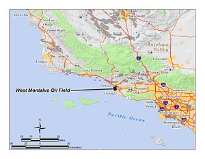 The West Montalvo Oil Field in Ventura County, California. Other oil fields are shown in dark gray.
The West Montalvo Oil Field is a large and productive oil field on the coast of Ventura County, California, in the United States, in and adjacent to the city of Oxnard. Discovered in 1947, it has produced approximately 43.7 million barrels (6,950,000 m3) of oil, and retains about 2.2 million recoverable with current technology, in both the onshore and offshore areas. The offshore portion of the field is exploited from wells directionally drilled from onshore near McGrath Lake, from within an enclosure above the high-tide line at McGrath State Beach. Most of the field, both onshore and offshore, is operated by Venoco, Inc., an independent petroleum company based in Carpinteria.[1]
The West Montalvo field was also the first dry natural gas field of commercial value to be discovered in Ventura County; in its lifetime it has produced over 43 billion cubic feet (1.2×10⁹ m3) of gas.[1][2]
Contents
Setting
 Reliant Energy's Mandalay Generating Station, on the West Montalvo Oil Field north of Mandalay Beach Park.
The oil field underlies the portion of coastline just south of the outlet of the Santa Clara River, including several state and county parks (including McGrath State Beach, Mandalay Beach Park, and Oxnard Shores Park). While parts of the oil field are within the city of Oxnard, most of it is within an unincorporated region east of the intersection of Harbor Boulevard and Gonzales Road, a mixed-use area of agricultural fields interspersed with oil wells and associated production and processing facilities. The terrain is almost all flat, save for berms and sand dunes at the shoreline. Elevations on the field range from sea level to about 40 feet (12 m) above sea level, and drainage is to the west and southwest, via a system of canals. Total productive area of the field is 780 acres (316 ha), with 200 of that being offshore.[2]
Some oil field and power generation facilities are in enclosures within the parks and open spaces. Venoco operates a row of wells near McGrath Lake which drill into the offshore portion of the field; visitors to McGrath State Beach can walk past them along the beach. Reliant Energy's 560-megawatt gas-fired Mandalay Generating Station is north of and adjacent to Mandalay Beach Park. An oil-gas separator adjacent to the Mandalay plant processes gas from the offshore Santa Clara and Hueneme fields and sells the gas to Reliant for use at the power plant.[3] Mandalay Beach Park consists of 94 acres (38 ha) of land left in its natural state, without amenities, and contains habitat for the endangered snowy plover.[4]
Venoco operates one oil well within Mandalay Beach Park, "McGrath 4 Well No. 1218", in a walled enclosure; as the well predated creation of the park, it is allowed to remain. This oil well is one of the most productive in the entire field, producing over 64,000 barrels (10,200 m3) of oil in 2009 alone, over 176 barrels per day (28.0 m3/d).[5]
The climate in the region is Mediterranean, with cool, rainy winters and warm, rainless summers, in which the heat is moderated by frequent morning coastal low clouds and fog. Annual precipitation is around 15 inches (380 mm), almost all in the winter, and all in the form of rain. The mean annual temperature is 56 to 60 degrees Fahrenheit; freezes occur rarely.[6]
Geology
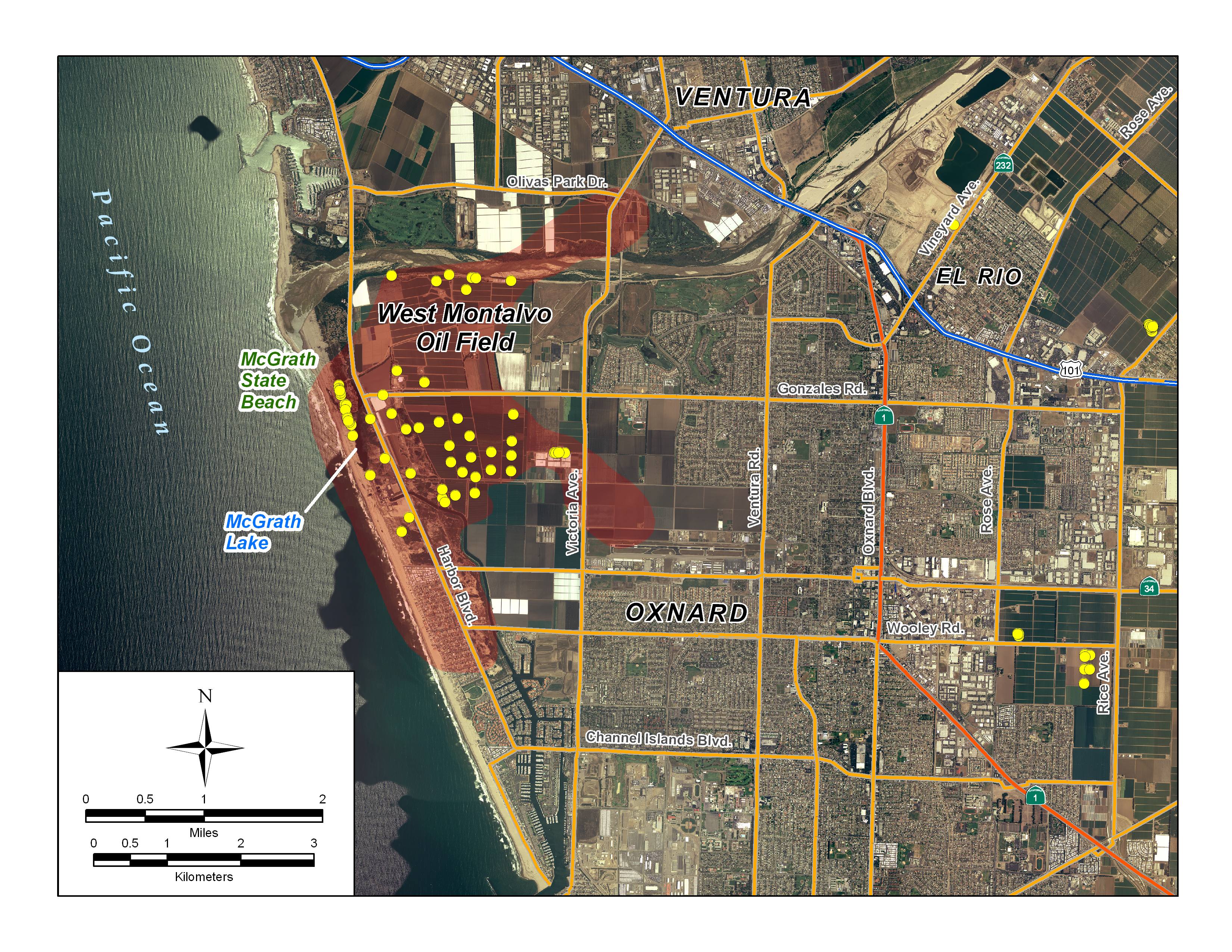
 Detail of the Montalvo field, showing its location relative to Ventura, Oxnard, and other urbanized areas in the coastal region. Yellow dots represent locations of active oil wells as of 2008.
The Montalvo field is an accumulation of oil within an eastward-plunging anticline. Within the anticline, numerous Pliocene-age sand units contain petroleum of various types. These sand units pinch out, and many are lenticular, with impermeable units above and below. The anticline is bounded on the north by a branch of the Oakridge Fault, and the anticline itself is broken in many places by small faults perpendicular to the Oakridge.[7][8]
Within the upper Pico Formation, many lenticular sand units contain natural gas; underneath this unit is the McGrath Zone, which was the first to be discovered, and which contains oil at an API gravity of 28. Beneath the McGrath, and separated by an unconformity, portions of the Miocene-age Santa Margarita and Monterey Formations show in drilling logs; yet another unconformity marks the top of the Colonia Zone, of Oligocene age, which contains more lenticular and pinched-out reservoirs of oil sands.[7]
History, production and operations
 McGrath 4 Well No. 1218, within Mandalay Beach Park, operated by Venoco, Inc. This well produced over 64,000 barrels of oil in 2009 alone.[5]
Standard Oil Company of California discovered the field in April 1947 by drilling into the McGrath producing horizon. The first well produced 154 barrels per day (24.5 m3/d), encouraging further exploration. In 1951 they found the Colonia Pool at 11,500 feet (3,500 m), which had a heavier oil with high sulfur content, and following the trend west, discovered the offshore portion of the field in June 1953 by drilling into the Oligocene-age Sespe Formation, where they also found oil at the 11,500-foot (3,500 m) depth. This producing horizon was also part of the Colonia Zone. This unit remains richly productive.[9]
The field has changed owners several times. In 1977, Standard Oil Company of California became Chevron, and the field was run under that logo. Chevron sold the field to Bush Oil Company of Taft, California, on May 1, 1990. Bush Oil ran the field for only two years, selling it to Berry Petroleum in 1992.[10] In May 2007, Venoco Inc. acquired the field from Berry Petroleum for $63 million, intending to develop the difficult deep tar sands and heavy crude using methods they had used successfully elsewhere. As of 2010 they are the principal operator on the field, and had begun to redevelop wells in the most productive reservoirs; by the end of 2008 the field was one of the top ten in California by largest production increase of the preceding year.[1]
Field operators have tried several enhanced recovery projects to improve production rates. In the McGrath pool, gas injection was used from 1956 to 1968, and the zone has been waterflooded since 1963, in an attempt to boost reservoir pressure. Both methods also have been used on the Colonia pool, with gas injection running from 1964 to 1971, and waterflooding since 1960.[11]
Oil produced in the field goes to the small (2,800-barrel (450 m3)-per-day) Oxnard Refinery, owned by Tenby Inc., in an unincorporated area on Fifth Street near the eastern Oxnard city limit. This refinery also processes oil from the Oxnard field upon which the refinery is located. Other petroleum processing facilities nearby include one west of the intersection of Harbor Boulevard and Gonzales Road, as well as two near the Santa Clara River, east of Harbor Boulevard.[12]
References
- California Oil and Gas Fields, Volumes I, II and III. Vol. I (1998), Vol. II (1992), Vol. III (1982). California Department of Conservation, Division of Oil, Gas, and Geothermal Resources (DOGGR). 1,472 pp. Ventura Oil Field information pp. 572–574. PDF file available on CD from www.consrv.ca.gov.
- California Department of Conservation, Oil and Gas Statistics, Annual Report, December 31, 2008.
- Keller, Margaret. Ventura Basin Province, U.S. Geological Survey Digital Data Series DDS-30, Release 2, one CD-ROM, 19 p. + supporting maps, figures, and tables. Available here
Notes
- ^ a b c "2008 Report of the state oil & gas supervisor". Department of Oil, Gas, and Geothermal Resources. California Department of Conservation ("DOGGR 2009"). 2009. ftp://ftp.consrv.ca.gov/pub/oil/annual_reports/2008/PR06_Annual_2008.pdf. Retrieved January 22, 2010. p. 132, 162
- ^ a b DOGGR, p. 289
- ^ Reliant Energy description of the Mandalay Power Plant
- ^ Ventura County Parks Division: description of Mandalay Beach Park
- ^ a b Well 1218 query from California Department of Conservation database
- ^ Eco-subregion description
- ^ a b DOGGR, p. 288-290
- ^ Moir, Leo H. Montalvo Oil Field, Ventura County. AAPG Bulletin, Volume 34 (1950)
- ^ DOGGR, p. 668-669
- ^ Well Record for McGrath Well No. 1218; p. 8-13.
- ^ DOGGR, p. 290
- ^ Ventura County Planning Department policies document, p. 7-8.
Coordinates: 34°12′53″N 119°14′20″W / 34.2146°N 119.2390°W
Categories:- Geography of Ventura County, California
- Oil fields in California


Wikimedia Foundation. 2010.