- Morton Bagot
-
Coordinates: 52°16′52″N 1°50′11″W / 52.28118°N 1.83652°W
Morton Bagot 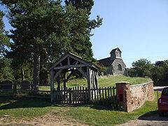
Holy Trinity Church and Lych gate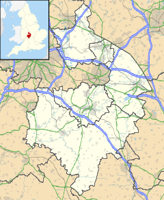
 Morton Bagot
Morton Bagot shown within WarwickshirePopulation 153 (2001 Census) OS grid reference SP11366460 District Stratford-on-Avon Shire county Warwickshire Region West Midlands Country England Sovereign state United Kingdom Postcode district B80 Dialling code 01527 Police Warwickshire Fire Warwickshire Ambulance West Midlands EU Parliament West Midlands UK Parliament Stratford-on-Avon List of places: UK • England • Warwickshire Morton Bagot is a small village in the Stratford-on-Avon district of Warwickshire, England. It lies about 1.5 miles (2 km) east of the Birmingham-Alcester road, the modern A435 and Roman Ryknild Street, 6.5 miles (10 km) north of Alcester, 9.5 miles (15 km) from Stratford upon Avon and 12 miles from Warwick, across the valley of a small brook, flowing south-east to join the River Arrow. A road from Oldberrow to Spernall runs north and south through the middle of the parish of Morton Bagot, Oldberrow and Spernall, past the church. The name means the settlement of the moor,[1] the Bagot element coming from the name of the lords of the Manor who added their name when they came into possession during the reign of Henry II.[2]
The elevation varies from 200 feet (61 m) to 400 feet (120 m), the highest point being at Bannum's Wood.There is no main village and there has been considerable depopulation here since the 18th century.[3] In 2001 the whole parish had a population of 153.
Contents
History
Morton Bagot is recorded in the Domesday Book as part of the land of Robert De Stafford as follows " in Ferncombe Hundred, Hugh holds 2 hides in Mortone (Bagot). Land for 4 ploughs. In lordship 1; 2 slaves; 5 villagers and 5 smallholders with 2 ploughs. Meadow, 3 furlongs long and 6 perches wide; woodland ½ league long 1 furlong wide. The value was 30s; now 50s. Grimulf held it freely."[4] Dugdale however states that it was part of the possessions of Waga of Wooton Wawen whose lands there were also given to de Stafford. Robert de Stafford was descended from the de Tonei family and had fought stoutly with Duke William against King Harold as a result he had this and other lands bestowed on him. He made Stafford his principal seat, where he had a strong castle and assumed his surname from thence.[5]
In 1805 The Times noted with some amusement that the local priest had dislocated his jaw when attempting a particularly loud Amen.[6]
Governance
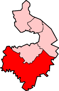
Morton Bagot is part of the Sambourne ward of Stratford on Avon District Council and represented by Councillor Justin Kerridge, Conservative.[7] Nationally it is part of Stratford-on-Avon constituency, whose current Member of Parliament following the 2010 election is Nadhim Zahawi of the Conservative Party. It is included in the West Midlands electoral region of the European Parliament and the six members are; Mike Nattrass (UK Independence), Liz Lynne (Liberal Democrat), Malcolm Harbour (Conservative), Michael Cashman (Labour), Philip Bradbourn OBE (Conservative) and Nicole Sinclaire (UK Independence).
Notable buildings
The parish church of the Holy Trinity is a small building dating from the end of the 13th century, the list of Rectors begins in 1282 with Ralph Bagot. It stands on a mound with a steep bank to the south it is approached by way of a lych gate erected in 1936 by Cannon Warren the then Rector,[2] there are the remains of a post box set into an adjacent wall. The church consists of a chancel, nave, south porch and a small timbered bell-cote with old oak beams containing two bells,[2] still rung today. These probably date to the early 16th century: the smaller, inscribed 'Sanctae Trinitas', is by an unknown founder; the other is inscribed with the name 'Maria' four times and has crosses, fleurs-de-lis, and king's heads as stops between them; it came from the Worcester foundry, probably by Nicholas Grene (died 1547).[8] In spite of Victorian restorations there remain some pre-Reformation features including window openings and a piscina with a plain ogee head and a very shallow basin cut off in front dating probably from the 14th century.[9] The east wall may have been rebuilt and the west end of the nave extended in the 15th century, whilst the south porch, tiled roofs and bell-turret are of about 1600. The font is a plain octagonal stone, thickly colourwashed, with a moulding of the 13th century at the top and another at half height. It has a 16th-century flat wood cover with moulded cross-framing and pierced by two holes for the former staples.[3] There are a number of memorials in the church. The Nave contains an oak memorial to Lance Corporal, John Thomas Ross, 4th Battalion Royal Berkshire Regiment who died of wounds in France on 28 March 1918 aged 21 he is buried in Namps-Au-Val British cemetery, in the Department of the Somme, France. He was the son of Mrs. A. Ross, of Chuter Green, Morton Bagot, Studley, Warwickshire.[10][2] The Chancel contains two memorials, on the South side one to the Holyoake family, landowners in the 18th century, whilst the one on the North side is to Thomas Walker, of Studley Castle, Lord of the Manor of Morton Bagot, who died in 1887. John Burman noted that the church was lit by candles[2] and this is still true today giving Winter services a very individual spiritual feeling. Details and times of services can be found on the arden marches churches website [3]
-
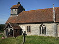
Holy Trinity Church
-

The East Window
-

The Chancel
-

The Font
Behind the church there are earthworks which are believed to be the site of a castle or fortified manor house. Traces of a moat near Church farm may perhaps mark the site of a building described in the 17th century as Lord Carington's Lodge House, which was then the largest house in the village but has now quite disappeared.When assessed for the hearth tax it had 7 hearths.[3] The interior of the earthworks however, are occupied by a 17th century timber framed barn that is contemporary with Church Farm (to the immediate NW). There is no surface evidence of an earlier building so the Victoria County History supposition that the earthworks were connected with Lodge House is questionable, but the position of moat close to the Church does implie a manorial origin. The size and depth of the earthworks suggests that this may be a small ring-motte. However, the barn standing on the site appears to be constructed out of earlier re-used material, so it is just possible that this could have been the site of Lodge House. The earthworks are a Scheduled Monument[4]
References
- ^ Place Names in the Landscape, Margaret Gelling 1984 ISBN0-460-04380-3
- ^ a b c d Warwickshire People and Places, John Burman 1936
- ^ a b c A History of the County of Warwick: Volume 3: Barlichway hundred (1945)
- ^ Domesday Book for Warwickshire, Phillimore edited by John Morris ISBN 0 85033 141 2
- ^ William Dugdale, The Antiquities of Warwickshire, 1656
- ^ The Times, 30 October 1805, A bet was made some time since between...
- ^ [1]
- ^ Tilley and Walters, Church Bells of Warwickshire, 192
- ^ Old Warwickshire Churches, W. Hobart Bird 1936
- ^ Commonwealth War Graves Commission
External links
 Media related to Morton Bagot at Wikimedia CommonsCategories:
- Villages in Warwickshire
- Hamlets in England
-


Wikimedia Foundation. 2010.