- Mount Jinfo
-
Mount Jinfo 金佛山 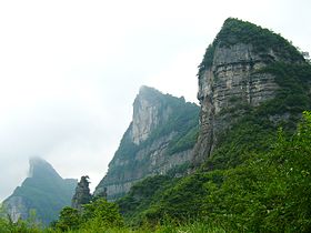
A Glimpse at South Side of Mount JinfoElevation 2,238 m (7,343 ft) Prominence 2,238 m (7,343 ft)
Highest point Feng Chui LingLocation Chongqing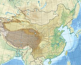
 Mount Jinfo
 China
ChinaRange Dalou Mountains Coordinates 29°04′N 107°18′E / 29.067°N 107.3°ECoordinates: 29°04′N 107°18′E / 29.067°N 107.3°E Climbing First ascent March 1881
 Edward Harper Parker (4850 feet)
July 19th, 1893
Isaac Mason (highest peak)
Jinfo Shan (Golden Buddha Mountain, Jinfoshan, Chin Shan, Jinfushan, Chin fu shan, chin fo shan, Chinese: 金佛山), the highest peak of Dalou Mountains, located in the upper reach of the Yangtze River, is situated in Nanchuan District, the Municipality of Chongqing. Jinfo Shan is an isolated mountain with cliffs up to 300 m surrounding its relatively flat top. Its major vegetation types include subtropical broadleaf forest, coniferous forests and subalpine meadow. Besides typical karst topography of gorges, stone forests and cave systems, Jinfo Shan is well known for its exceptional plant diversity of 4768 seed plants.[1] It is also a refuge to endangered animals confined to karst regions such as Francois Langur Trachypithecus francoisi. With its outstanding karst features and superb biodiversity, Jinfo Shan has been listed as a tentative World Heritage site since 2001.[2]Geography
Mt. Jinfo is a syncline mountain. The platform and terrace are composed of Permian limestone in the upper part with about 2000m a.s.l. In the meanwhile, karst geomorphologies in large scale on the surface or underground are found. The shale and sandstone of Silurian lay in the middle of Jinfo from 1000m to 1500m asl.. The low part of Jinfo is supported by the limestone and dolomite of Cambrian and Ordovician. Plenty of small- and microforms of karst are formed in this area. There are many cliffs and gorges in Jinfo Mt., the north slope is steep and the south slope is slight. The geomorphology of the Jinfo can be divided into two types:
- Gorge in the low part of Jinfo Mt. whose elevation is about 800-1200m asl and relative height about 500m. It formed by water down cutting and eroding.
- Platform of Mid-mountain distributes the area above 1200m asl of Jinfo Mt., Bozhi Mt. and Qingba Mt.. The relative height is 500-1000m. The way of the mountain extension is identical to the tectonic line. The top of the Mts. is a relic erosional basis.[3]
Climate
It is in the subtropical humid monsoon zone with annual mean temperature of 8.2°C and precipitation of 1,434.5 mm on the top of the mountain.[4]
References
- ^ Yi, S.; Huang, Y., Shen, M., Xie, S & Liang, G. (2007). "Additions to the seed plants flora of Jinfo Mount. Nature Reserve in Chongqing.". Ecological Science (26): 242–245.
- ^ "Jinfushan Scenic Spot". UNESCO World Heritage Centre. http://whc.unesco.org/en/tentativelists/1624/.
- ^ Kuang, Mingsheng. "Karst Ecological System of Jinfo Mountain of Chongqing". Karst Dynamics Laboratory and Network Center of Guangxi Normal University. http://www.karst.edu.cn/guidebook/chongqing.htm. Retrieved 26 September 2011.
- ^ Wu, Yuexia; Yongjun Jiang, Daoxian Yuan and Linli Li (2008). "Modeling hydrological responses of karst spring to storm events: example of the Shuifang spring (Jinfo Mt., Chongqing, China)". Environ Geol (55): 1545–1553.
Categories:- Mountains of China


Wikimedia Foundation. 2010.