- U.S. Route 322 in Pennsylvania
-
This article is about the section of U.S. Route 322 in Pennsylvania. For the entire length of the highway, see U.S. Route 322.
U.S. Route 322
Route information Maintained by PennDOT Length: 370 mi[1] (595 km) Major junctions West end:  US 322 at Ohio border in West Shenango Township
 I-79 in Meadville
 I-80 in Clarion Township

 I-99 / US 220 in State College

 US 22 / US 522 in Lewistown

 US 11 / US 15 in Duncannon
 I-81 in Harrisburg
 I-83 in Harrisburg
 US 30 in Downingtown
 US 1 in Concordville
 I-95 in Chester
East end: US 322 at the Commodore Barry Bridge at New Jersey border in ChesterHighway system United States Numbered Highways
List • Bannered • Divided • ReplacedRoads in Pennsylvania
Interstate • US • State • Legislative←  PA 321
PA 324  →
→U.S. Route 322 is a U.S. highway running from Cleveland, Ohio east to Atlantic City, New Jersey. In the U.S. state of Pennsylvania, the route runs from the Ohio border in West Shenango Township southeast to the Commodore Barry Bridge over the Delaware River in Chester, at which point the route crosses into New Jersey. The route passes near several cities, including DuBois, State College, and Harrisburg.
Route description
In Pennsylvania, US 322 is signed as 28th Division Highway, in honor of the 28th Infantry Division.[2] The route enters Pennsylvania taking a northeasternly course. In Meadville, US 322 overlaps U.S. Route 6 and U.S. Route 19. Southeast of Meadville, the highway runs generally southeast through Crawford, Venango and Clarion Counties. Once leaving Clarion borough, US 322 interchanges I-80, at exit 70. From I-80, it continues on a solid east–west routing crossing Jefferson County. The route overlaps U.S. Route 219 near the northern terminus of U.S. Route 119, south of Du Bois. East of US 219, the route takes a southward turn to traverse Moshannon State Forest, before taking an east–west alignment. From Clearfield to U.S. Route 220, the highway runs southeast and is partly divided.[2]
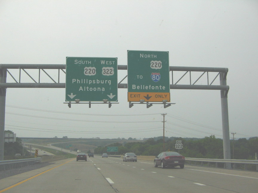
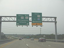 US 322 near State College. The blank spots have since been replaced with I-99 shields.
In the State College area, the current alignment of US 322 overlaps Interstate 99 and US 220 for 12 miles (19 km)[3] Northeast of Port Matilda, Interstate 99, US 220, and US 322 depart the Appalachian Thruway via an interchange and proceed east on the 28th Division Highway while the Thruway continues to the northeast as US 220 Alternate.[4]
West of State College, the 28th Division Highway becomes the Mount Nittany Expressway after intersecting with Scotia Road and North Atherton Street (Business US 322, which goes through downtown State College). The I-99/US 220/US 322 overlap ends at a complex interchange north of downtown State College.[2][5]
 A view from US 322 outside Spring Mills
East of the overlap, US 322 continues southeastward through State College and its immediate suburbs on the Mount Nittany Expressway. After three exits, US 322 reverts to an at-grade highway two miles east of State College in Boalsburg, merging with US 322 Business and proceeding eastward along Boal Avenue as the route exits the State College area. Between Boalsburg and Lewistown, the highway traverses Tussey Mountain and Jacks Mountain, in the Rothrock State Forest, as it turns to the south.[6][7]
Between Potters Mills and Lewistown, US 322 is a limited-access road. Near Lewistown, it briefly overlaps U.S. Route 522 and begins a long overlap with US 22. South of Lewistown, US 22/US 322 enters the Lewistown Narrows, an 8-mile (13 km) stretch of road through the Juniata River water gap in Shade Mountain. Construction to convert this section of the highway from a two-lane highway to a divided, limited-access four lane highway was completed in December 2007,[8] and it includes building the longest mechanically stabilized earth wall in the U.S.[9] The highway exits the narrows in Arch Rock, traverses Juniata County and Perry County, and crosses the Tuscarora Mountain through a water gap on a southeastward course along the banks of the Juniata River. After crossing the Susquehanna at Clarks Ferry (coinciding with the Appalachian Trail), the freeway runs south and parallels the river for 15 miles (24 km) before entering the Harrisburg Area.[10][11]
North of downtown Harrisburg, the US 22/322 overlap interchanges with Interstate 81 at exit 67. While US 22 continues through the interchange and heads into downtown, US 322 departs US 22 and joins I-81 northbound. I-81 and US 322 remain concurrent for three miles (5 km) to exit 70, where US 322 exits, following Interstate 83, which has its northern terminus at the interchange, south through the innermost suburbs of Harrisburg.[12][13] After two exits, US 322 returns to an at-grade roadway at the Eisenhower Interchange (exit 47), departing I-83 and following Paxton Street east toward Hummelstown.[2][14] West of the borough, US 322 becomes a freeway once again, becoming the Hummelstown Bypass after crossing Fiddlers Elbow Road. The route runs south of Hummelstown, interchanging with two local roads before meeting the eastern terminus of Pennsylvania Route 39 and the western terminus of U.S. Route 422 at an interchange midway between Hummelstown and Hershey.[15]

US 322 heads east from the interchange, becoming the at-grade West Governor Road as it passes south of Hershey. East of the Hershey area, the route runs eastward via the scenic Horseshoe Pike traversing Lebanon County. The Horseshoe Pike portion ends west of Cornwall, where US 322 bypasses the town.[16] East of the bypass, the route becomes grade-leveled again, enters Lancaster County and passes over the Pennsylvania Turnpike (I-76). This stretch runs eastward, again known as the 28th Division Highway. East of Ephrata, US 322 interchanges U.S. Route 222 and continues southeastward through the Pennsylvania Dutch Country, intersecting PA 23 in Blue Ball, and then reverts back to the name Horseshoe Pike before crossing PA 10 in Honey Brook after entering Chester County. In Downingtown, US 322 interchanges US 30.[17] After passing under US 30 it continues into Downingtown as Manor Ave before intersecting US 30 Business/Lancaster Ave. The route turns left at the intersection and runs concurrent US 30 Business for a block while crossing the Brandywine Creek. The route then turns right at the next intersection onto Brandywine Ave as it exits the borough and becomes Downingtown Pike.
Where the highway approaches the West Chester Area, it bypasses the borough via West Chester Bypass. At the end of the at-grade bypass, the eastbound lane of US 322 merges onto U.S. Route 202 southbound to begin an overlap. After three exits, the US 202/US 322 overlap becomes grade leveled running north–south.[18] South of West Chester, the overlap is a major divided highway in Chester County and then entering Delaware County. In Concord Township, US 322 turns east onto U.S. Route 1 and leaves U.S. Route 202 at Painters' Crossroad. One mile conjoined with US 1 east of US 202, US 322 leaves US 1 via a turn southeastward to become the Conchester Highway. Approaching Chester, the route has three exits (one with PA 452, Bethel Road at the CSX rail line, and Highland Avenue) before beginning an overlap with Interstate 95, at exit 3A. The overlap with I-95 is a brief one, where US 322 leaves I-95, at exit 4, and crosses the Delaware River to enter New Jersey via the Commodore Barry Bridge.[19]
Major intersections
County Location Mile Destinations Notes Crawford West Shenango Township 0.0 US 322Ohio state line Mercer Jamestown  PA 58 west (Jamestown-Kinsman Road)
West end of PA 58 concurrency PA 58 east (Liberty Street)East end of PA 58 concurrency Crawford Hartstown  PA 18 south (Main Street)
West end of PA 18 concurrency Conneaut Lake 
 US 6 west / PA 285 west (Water Street)
West end of US 6/PA 285 concurrency PA 285 east (3rd Street)East end of PA 285 concurrency PA 18 northEast end of PA 18 concurrency Meadville 
 US 19 south (Perry Highway) / PA 98
West end of US 19 concurrency, southern terminus of PA 98 I-79Interchange  PA 102 (Pennsylvania Avenue)
Southern terminus of PA 102 US 6 east / US 19 northEast end of US 6/19 concurrency Cochranton  PA 173
Venango Franklin  PA 427
Southern terminus of PA 427  PA 417
Southern terminus of PA 417 
 US 62 south / PA 8 south (Liberty Street)
West end of US 62/PA 8 concurrency US 62 north / PA 8 northEast end of US 62/PA 8 concurrency Cranberry  PA 257
Southern terminus of PA 257 Nickleville  PA 38
PA 38Northern terminus of PA 38 Clarion Kossuth  PA 338
Northern terminus of PA 338 Shippenville  PA 208 west (Railroad Street)
West end of PA 208 concurrency PA 208 east (School Street)East end of PA 208 concurrency  PA 66 south
West end of PA 66 concurrency PA 66 northEast end of PA 66 concurrency Clarion  PA 68 (5th Avenue)
Eastern terminus of PA 68 Clarion Township I-80Interchange Jefferson Corsica  PA 949 (Olean Road)
Southern terminus of PA 949 Brookville 
 PA 28 south / PA 36 north (Allegheny Boulevard)
West end of PA 28/36 concurrency PA 36 south (White Street)East end of PA 36 concurrency PA 28 northEast end of PA 28 concurrency Reynoldsville  PA 950 (Broadway Street)
Southern terminus of PA 950  PA 310 (5th Street)
Northern terminus of PA 310 Clearfield DuBois  US 119 (Buffalo Pittsburgh Highway)
 US 219 north
West end of US 219 concurrency Luthersburg  PA 410
Eastern terminus of PA 410 US 219 southEast end of US 219 concurrency Clearfield  PA 153 north
West end of PA 153 concurrency  PA 879 east (River Road)
West end of PA 879 concurrency PA 153 south (2nd Street) / PA 879 westEast end of PA 153/879 concurrency Woodland  PA 970
Pleasant Hill  PA 53 north
West end of PA 53 concurrency Centre Philipsburg PA 53 south (North Centre Street)East end of PA 53 concurrency  PA 504 (Presque Isle Street)
Port Matilda West end of freeway I-99 / US 220 south – AltoonaWest end of I-99/US 220 concurrency; I-99 exit 62 State College Grey's Woods, Waddle I-99 exit 68 


US 322 Bus. east (Atherton Street)Eastbound exit, westbound entrance; I-99 exit 69 Valley View Drive - Park Forest Westbound exit, eastbound entrance; I-99 exit 69 Toftrees, Woodycrest I-99 exit 71 I-99 / US 220 north to I-80 – BellefonteEast end of I-99/US 220 concurrency; I-99 exit 73 Innovation Park, Penn State University  PA 26 (College Avenue) – State College, Bellefonte
 PA 45 (Earlystown Road) – Oak Hall, Boalsburg, Lemont, Old Fort
US 322 Bus. (Atherton Street) to PA 45 – BoalsburgWestbound exit, eastbound entrance East end of freeway Potters Mills  PA 144
Southern terminus PA 144 Mifflin Armagh Township West end of freeway Milroy Reedsville  PA 655 – Reedsville
Northern terminus PA 655 Burnham Yeagertown, Burnham Lewistown US 22 west / US 522 southWest end of US 22/US 522 concurrency Electric Avenue Westbound exit and entrance US 522 north (Walnut Street)East end of US 522 concurrency East Charles Street Eastbound exit, westbound entrance
US 22 Bus. west – LewistownWestbound exit, eastbound entrance Juniata Fermanagh Township Arch Rock Road Mifflintown  PA 35 – Mifflintown, McAlisterville
Port Royal  PA 75 south – Port Royal
Thompsontown  PA 333 – East Salem, Thompsontown
Pfoutz Valley Road Westbound exit, eastbound entrance Perry Millerstown  To PA 17 – Millerstown
Newport  PA 34 – Newport, New Bloomfield
Midway Westbound exit, eastbound entrance Watts Township Watts Amity Hall Dauphin Reed Township US 11 / US 15 – Camp Hill, SelinsgroveEast end of freeway West end of freeway  PA 849 west – Duncannon
Eastern terminus of PA 849 Clarks Ferry Bridge over Susquehanna River  PA 147 north – Halifax
Interchange, Southern terminus of PA 147 Speeceville  PA 325 east (Mountain Road)
Interchange, Western terminus of PA 325 Dauphin  PA 225 north (Claster Boulevard) – Halifax, Dauphin
Interchange, Southern terminus of PA 225 Dauphin Boro, Stony Creek Westbound exit Fort Hunter  PA 443 (Fishing Creek Valley Road) – Fishing Creek, Rockville
Harrisburg  PA 39 – Linglestown, Rockville
 I-81 south / US 22 east (Cameron Street) to PA 230 – Carlisle
Interchange, west end of I-81 concurrency, east end of US 22 concurrency; I-81 exit 67 Progress Avenue I-81 exit 69 I-81 north / I-83 – HazletonEast end of I-81 concurrency, northern terminus of I-83, west end of I-83 concurrency; I-81 exit 70, I-83 exit 51 US 22 (Jonestown Road) – Progress, Colonial ParkI-83 exit 50 Union Deposit Road I-83 exit 48  I-83 south / I-283 south (Eisenhower Interchange) – York, Highspire
Interchange, east end of I-83 concurrency,
northern terminus of I-283; I-83 exit 46B-47Penhar Drive East end of freeway Hummelstown West end of freeway Hummelstown Hershey  US 422 (Chocolate Avenue) / PA 39 (Hersheypark Drive) – Hershey
Interchange, western terminus of eastern segment US 422,
eastern terminus of PA 39East end of freeway  PA 743 (Cocoa Avenue)
Lebanon Campbelltown  PA 117 (Forge Road)
Fontana  PA 241 south (Elizabethtown Road)
West end of PA 241 concurrency  PA 934 (White Oak Street)
Southern terminus of PA 934 PA 241 north (Colebrook Road)East end of PA 241 concurrency Quentin  PA 419 (Main Street)
Southern terminus of PA 419 West end of freeway Cornwall  PA 72 north (Quentin Road) – Lebanon
Westbound exit, eastbound entrance, west end of PA 72 concurrency PA 117 – Mount GretnaSouthern terminus of PA 117 PA 72 south (Lebanon Road) – LancasterEastbound exit, westbound entrance, east end of PA 72 concurrency East end of freeway Lancaster Brickerville  PA 501 (Furnace Hills Pike)
Ephrata  PA 272 (Reading Road)
Interchange  US 222
Interchange Blue Ball  PA 23 (Main Street)
East Earl  PA 897 north (Springville Road)
West end of PA 897 concurrency PA 897 south (Springville Road)East end of PA 897 concurrency Chester Honey Brook  PA 10 (Conestoga Avenue)
Brandywine Manor  PA 82 (Manor Road)
Downingtown US 30Interchange
US 30 Bus. west (Lancaster Avenue)West end of US 30 Bus. concurrency 
US 30 Bus. / US 322 Truck east (Lancaster Avenue)East end of US 30 Bus. concurrency
US 322 Truck west (Boot Road)West Chester
US 322 Bus. east (Downingtown Pike)West end of freeway North New Street At-grade intersection  To PA 100 north – Exton
Phoenixville Pike At-grade intersection  US 202 north – King of Prussia
Westbound exit, eastbound entrance, west end of US 202 concurrency Paoli Pike  PA 3 (Gay Street) – Newtown Square
Westtown Road Matlack Street At-grade intersection
US 322 Bus. west (High Street)Westbound exit, eastbound entrance East end of freeway Darlington Corners  PA 926 (Street Road)
Delaware Concordville US 1 south (Baltimore Pike) / US 202 south (Wilmington West Chester Pike)West end of US 1 concurrency,
east end of US 202 concurrency US 1 north (Baltimore Pike)East end of US 1 concurrency Booth Corner  PA 261 south (Foulk Road)
Interchange Boothwyn West end of freeway  PA 452 (Market Street)
Chester Bethel Road Highland Avenue Westbound exit I-95 south - WilmingtonWest end of I-95 concurrency; I-95 exit 3 I-95 north – PhiladelphiaEast end of I-95 concurrency; I-95 exit 4  US 13 (9th Street) US 322
Commodore Barry Bridge over Delaware River, New Jersey state line 1.000 mi = 1.609 km; 1.000 km = 0.621 mi References
- ^ "United States Routes: page 187" (PDF). AASHTO. http://www.transportation.org/sites/route/docs/USRN-page187_210Notes.pdf. Retrieved 2007-06-11.
- ^ a b c d PennDOT. Pennsylvania Official Tourism and Transportation Map 2006 (Map). ftp://ftp.dot.state.pa.us/public/pdf/BPR_PDF_FILES/MAPS/Statewide/otm/2006/otm_2006.PDF. Retrieved 2007-05-30.
- ^ "Interstate 99 project". PennDOT. http://www.penndot2.com/route26/index.html. Retrieved 2007-05-30.
- ^ MapQuest. Map of State College, PA (Map). http://www.mapquest.com/maps/map.adp?formtype=address&country=US&popflag=0&latitude=&longitude=&name=&phone=&level=&addtohistory=&cat=&address=&city=State+College&state=PA&zipcode=#west. Retrieved 2007-05-30.
- ^ Rand McNally (2007). Motor Carrier's Road Atlas (Map) (Deluxe ed.). p. 87, section WS 13.
- ^ Rand McNally (2007). Motor Carrier's Road Atlas (Map) (Deluxe ed.). p. 89, section EL 1.
- ^ MapQuest. East of State College, PA (Map). http://www.mapquest.com/maps/map.adp?searchtype=address&country=US&addtohistory=&searchtab=home&formtype=address&popflag=0&latitude=&longitude=&name=&phone=&level=&cat=&address=&city=State+College&state=PA&zipcode=#south. Retrieved 2007-06-01.
- ^ "Route 22/322 Lewistown Narrows Project News and Events" Penn. DOT
- ^ "Route 22/322 Lewistown Narrows Project" Penn. DOT
- ^ Rand McNally (2007). Motor Carrier's Road Atlas (Map) (Deluxe ed.). p. 89, section EL 2, EL 3, and EM 4.
- ^ TopoQuest. USGS Lewistown (PA) (Map). http://www.topoquest.com/map.asp?lat=40.60819&lon=-77.5574&symshow=n&datum=nad27&layer=DRG. Retrieved 2008-06-29.
- ^ Rand McNally (2007). Motor Carrier's Road Atlas (Map) (Deluxe ed.). p. 89, section ES 3, ES 4.
- ^ TopoQuest. Map of I-81 and I-83 interchange (Map). http://www.topoquest.com/map.asp?lat=40.31145&lon=-76.83918&symshow=n&datum=nad27&layer=DRG. Retrieved 2007-06-01.
- ^ MapQuest. Eisenhower Interchange Map (Map). http://www.mapquest.com/maps/map.adp?formtype=address&addtohistory=&address=&city=Harrisburg&state=PA&zipcode=&country=US&location=do4dg3F1BaQTShxp9oTKWk1vpgPtjhCFN9egxk38m%2bTw7PdStax3%2fnE4JKooJmqNOH10KB6f7zj%2f0aQWruNGK3cImDa2%2fVQXwBhvM5%2fqfjUwD6uO%2bieuGA%3d%3d&ambiguity=1#west. Retrieved 2007-06-02.
- ^ MapQuest. Hummelstown, Pennsylvania (Map). http://www.mapquest.com/maps/map.adp?formtype=address&addtohistory=&address=&city=Harrisburg&state=PA&zipcode=&country=US&location=do4dg3F1BaQTShxp9oTKWk1vpgPtjhCFN9egxk38m%2bTw7PdStax3%2fnE4JKooJmqNOH10KB6f7zj%2f0aQWruNGK3cImDa2%2fVQXwBhvM5%2fqfjUwD6uO%2bieuGA%3d%3d&ambiguity=1#east. Retrieved 2007-06-02.
- ^ Google, Inc. Google Maps – overview map of Cornwall, PA (Map). Cartography by Google, Inc. http://maps.google.com/maps?f=q&hl=en&q=Hershey,+Pennsylvania&ie=UTF8&ll=40.242847,-76.442184&spn=0.241621,0.455246&z=11&om=1. Retrieved 2007-06-11.
- ^ Google, Inc. Google Maps – overview map of Downingtown, PA (Map). Cartography by Google, Inc. http://maps.google.com/maps?f=q&hl=en&q=Hershey,+Pennsylvania&ie=UTF8&ll=40.242847,-76.442184&spn=0.241621,0.455246&z=11&om=1. Retrieved 2007-06-11.
- ^ Google, Inc. Google Maps – West Chester Area (Map). Cartography by Google, Inc. http://maps.google.com/maps?f=q&hl=en&q=Hershey,+Pennsylvania&ie=UTF8&ll=40.242847,-76.442184&spn=0.241621,0.455246&z=11&om=1. Retrieved 2007-06-12.
- ^ Google, Inc. Google Maps – U.S. Route 322 and Interstate 95 Interchange (Map). Cartography by Google, Inc. http://maps.google.com/maps?f=q&hl=en&q=Hershey,+Pennsylvania&ie=UTF8&ll=40.242847,-76.442184&spn=0.241621,0.455246&z=11&om=1. Retrieved 2007-06-12.
Roads in the Susquehanna Valley Beltway Interstate Highways U.S. Routes Limited-access Pennsylvania Routes Other Pennsylvania Routes PA 17 · PA 23 · PA 25 · PA 34 · PA 39 · PA 72 · PA 74 · PA 94 · PA 114 · PA 117 · PA 147 · PA 174 · PA 225 · PA 230 · PA 233 · PA 235 · PA 241 · PA 274 · PA 325 · PA 340 · PA 341 · PA 343 · PA 419 · PA 441 · PA 443 · PA 462 · PA 465 · PA 501 · PA 533 · PA 641 · PA 645 · PA 696 · PA 722 · PA 743 · PA 772 · PA 849 · PA 850 · PA 897 · PA 934 · PA 944 · PA 997 · PA 999Other Quadrant Routes SR 3015 · SR 3020Other notable roads Road transportation infrastructure of the metro Philadelphia area Interstates U.S. Routes Pennsylvania Routes New Jersey Routes Delaware Routes Named roads/streets Benjamin Franklin Parkway · Broad Street · City Avenue · Front Street · Girard Avenue · Market Street · Roosevelt Boulevard · South Street · Chestnut Street · Walnut Street
Pennsylvania Turnpike · New Jersey Turnpike · Delaware Turnpike · Atlantic City Expressway · Schuylkill Expressway · Delaware Expressway · Blue Route · Vine St Expressway · North South Freeway · Lancaster Avenue · Bethlehem Pike · Baltimore Pike · Black Horse PikeBridges Delaware Memorial Bridge · Commodore Barry Bridge · Walt Whitman Bridge · Ben Franklin Bridge · Betsy Ross Bridge · Tacony–Palmyra Bridge · Burlington–Bristol Bridge · Delaware River – Turnpike Toll Bridge U.S. Route 322Previous state:
OhioPennsylvania Next state:
New JerseyCategories:- U.S. Highways in Pennsylvania
- U.S. Route 322


Wikimedia Foundation. 2010.