- Mount Tabor (Oregon)
-
For the neighborhood of Portland surrounding Mt. Tabor, see Mount Tabor, Portland, Oregon.

Mount Tabor is the name of a dormant volcanic cinder cone, the city park on the volcano, and the neighborhood of Southeast Portland that surrounds it, all in Oregon. The name refers to Mount Tabor, Israel. It was named by Plympton Kelly, son of Oregon City pioneer resident Clinton Kelly.[1]
Contents
Cinder cone
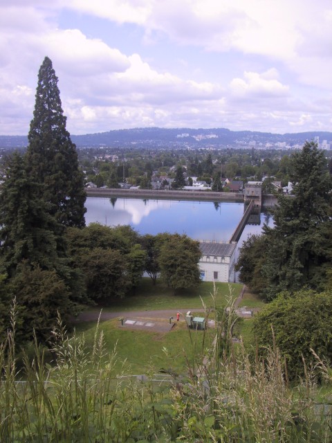
 Mount Tabor Reservoir
The peak of Mount Tabor is 636 feet (194 m) in elevation;[2] about two-thirds of this is prominence since the surrounding land is about 200 feet (61 m) elevation.[3]
Mount Tabor Park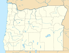

Location: Roughly bounded by S.E. Division Street, S.E. 60th Avenue, S.E. Yamhill Street, and S.E. Mountainview Drive, Portland, Oregon Coordinates: 45°30′41″N 122°35′39″W / 45.51139°N 122.59417°WCoordinates: 45°30′41″N 122°35′39″W / 45.51139°N 122.59417°W Built: 1903 Architect: Emanuel Tillman Mische, Charles P. Keyser Architectural style: Late Victorian, Late 19th And 20th Century Revivals Governing body: Local NRHP Reference#: 04001065[4] Added to NRHP: September 22, 2004 Near the peak, where a basketball court and outdoor amphitheater are now situated, part of the cinder cone has been cut away, and the rock is visible to park visitors. The remaining cinders were used to pave the nearby parking lot.
The Tabor cinder cone is part of the Boring Lava Field, an extensive network of cinder cones and small shield volcanoes ranging from Boring, Oregon to southwest Washington, and dating to the Plio-Pleistocene era. The lava field has been extinct for over 300,000 years.[5] Three other cinder cones from this field also lie within the city of Portland: Rocky Butte, Powell Butte, and Kelly Butte.
Portland is one of two cities in the United States to have an extinct volcano, Mount Tabor, within its boundaries. Bend, is the only other city in Oregon with a volcano within its city limits with Pilot Butte.[6][7] The volcanic nature of Mount Tabor became known in 1912, years after a public park was developed on it.
Park
Mount Tabor Park Reservoirs Historic District
Nearest city: Portland, Oregon Coordinates: 45°30′39″N 122°35′44″W / 45.51083°N 122.59556°W Built: 1894 Architect: Isaac Smith, et.al. Architectural style: Romanesque Governing body: Local NRHP Reference#: 03001446[4] Added to NRHP: January 15, 2004 The 196-acre (0.79-km²) Mount Tabor Park does not appear to have ever been formally ordained by the City as a park. According to archival records, an ordinance declaring Williams Park, named for a prominent citizen, was stopped by neighborhood activists wanting the historic name, Mt. Tabor Park, to be retained. No other ordinance appears to have been enacted to date. The entire park, including the Central Maintenance Yard, was listed in the National Register of Historic Places[8] in 2004. The nomination was forwarded by a community effort spearheaded and funded by the Mt. Tabor Neighborhood Association. Mt. Tabor Park is known for its reservoirs, three of which were accepted to the National Register of Historic Places in January 2004.[9][10] The reservoirs' nomination was also a community effort spearheaded by the Friends of the Reservoirs and funded by donations. The park was designed, along with other Portland parks, by Emanuel Tillman Mische, a highly pedigreed horticulturist and long-time landscape designer for the famed Olmsted Brothers landscape firm.[11] John Charles Olmsted, stepson and nephew, of the famed Frederick Law Olmsted, visited Portland in 1903 to help design the site for the Lewis and Clark World Exposition, on the request of Rev. Thomas Lamb Eliot, minister of the First Unitarian Church and relative of Charles Eliot, the son of the president of Harvard University and acclaimed landscape architect and partner in the Olmsted landscape firm in Brookline, Massachusetts. Rev. Eliot arranged for Olmsted to visit Seattle for park planning, too, in order to help make the long trip financially feasible. While John Charles Olmsted was in Portland, Rev. Eliot and other park supporters took him on a tour throughout the city so that he could create a grand plan of parks. Mt. Tabor Park was the largest Portland park until 1947 when Forest Park was created. The land making up the Mt. Tabor volcanic butte was identified for a park in the 1880s due to its ideal elevation for a water distribution system. City fathers formed a water committee and created a municipal water system piping water some 25 miles from the Bull Run River watershed, separate and west of Mt. Hood, to Mt. Tabor reservoirs and across the Willamette River to City Park reservoirs (now Washington Park) in 1894. The Bull Run watershed was among the first federal lands to be set aside in the Forest Reserve Act of 1891 and enacted by president Benjamin Harrison.
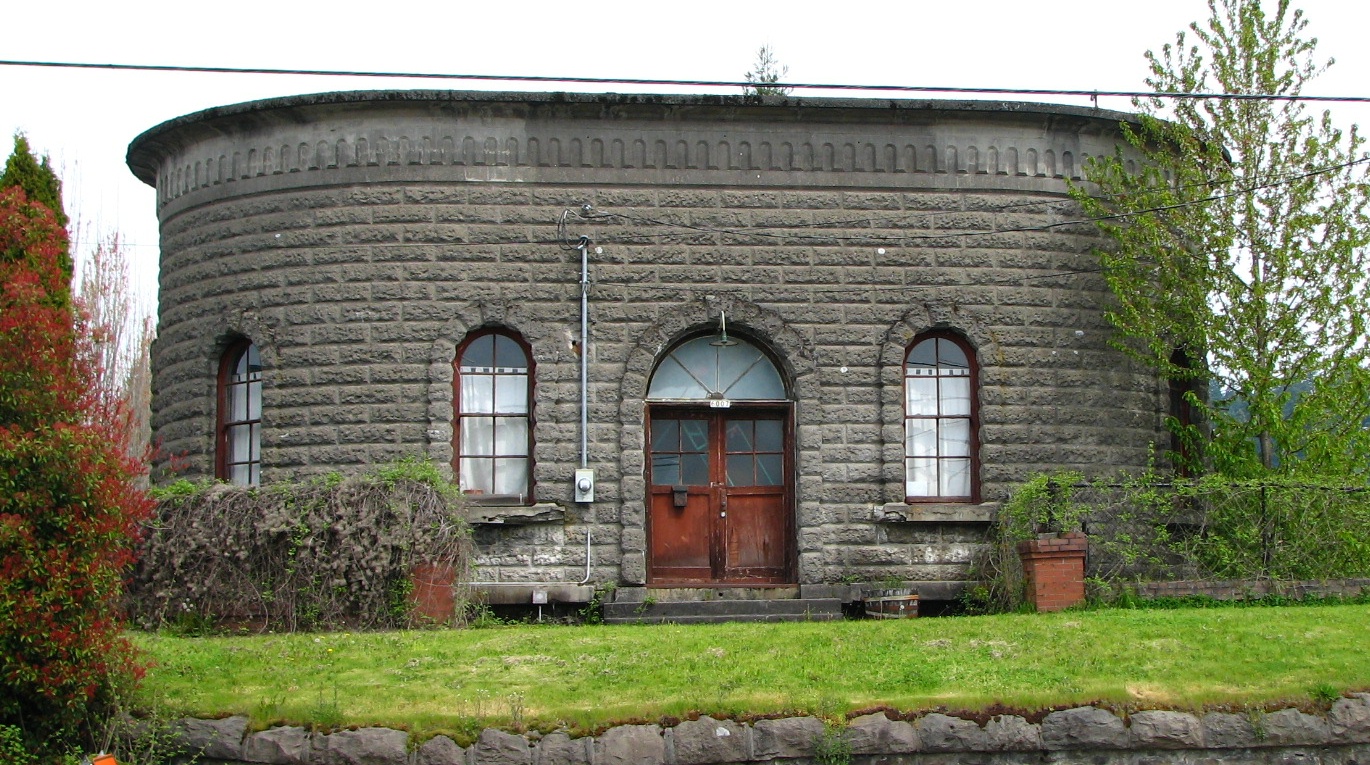
The Mount Tabor reservoirs were built during the period of 1894 and 1911, along with reservoirs in Washington Park. The reservoirs and their gatehouses are artistically constructed, incorporating extensive reinforced concrete, designed to look like stonework, by two early patented techniques by noted engineer Ernest L. Ransome[12] and wrought-iron fencing and lampposts designed by noted architect William M. Whidden. There were initially four above-ground reservoirs, numbered 1, 2, 5, and 6. (Reservoirs 3 and 4 are at Washington Park, and Reservoir 7 is a small underground reservoir near Mount Tabor's summit.) Reservoir 2, on the corner of SE 60th and Division, was decommissioned in the 1980s, and the property was sold to a private developer. Its gatehouse remains, and is used as a private residence. Reservoir 6 is the largest, with two 37 million gallon chambers; it also contains a fountain, which was unused for many years, however it was reactivated in early 2007.[13]
The park features a statue of The Oregonian editor Harvey W. Scott.[14] The larger-than-life statue was sculpted by Gutzon Borglum, notable for sculptures on Mount Rushmore.[14] The bronze statue was dedicated on July 22, 1933, with approximately 3000 in attendance, 23 years after Scott died.[14] Oregon governor Julius Meier was chairman of the event, and Chester Harvey Rowell gave a speech.[14]
Reservoir problems
These reservoirs, according to Portland's NBC affiliate KGW, are not filtered. This came to light June 30, 2008 when KGW reported two people were caught skinny dipping in one of the offline reservoirs the night of June 29. Reservoir officials say it's fortunate this particular reservoir was offline at the time, because draining and refilling it would have cost tens of thousands of dollars. Creating covers for the reservoirs has been proposed in the past but would cost the city about $500 million.[15] Mount Tabor Park also features a Depression-era sculpture by Gutzon Borglum (of Mount Rushmore fame) representing Harvey W. Scott, an early editor of The Oregonian.[16] The uncovered reservoirs were again in the news in early December 2009 when an E. coli outbreak warning was issued for Portland tap water. Residents were urged to boil the water they use for drinking and washing dishes.[17]
On June 15, 2011, a man was observed urinating in a nearly 8,000,000 gallon reservoir, prompting city officials to drain the water at a cost of around $36,000.[18]
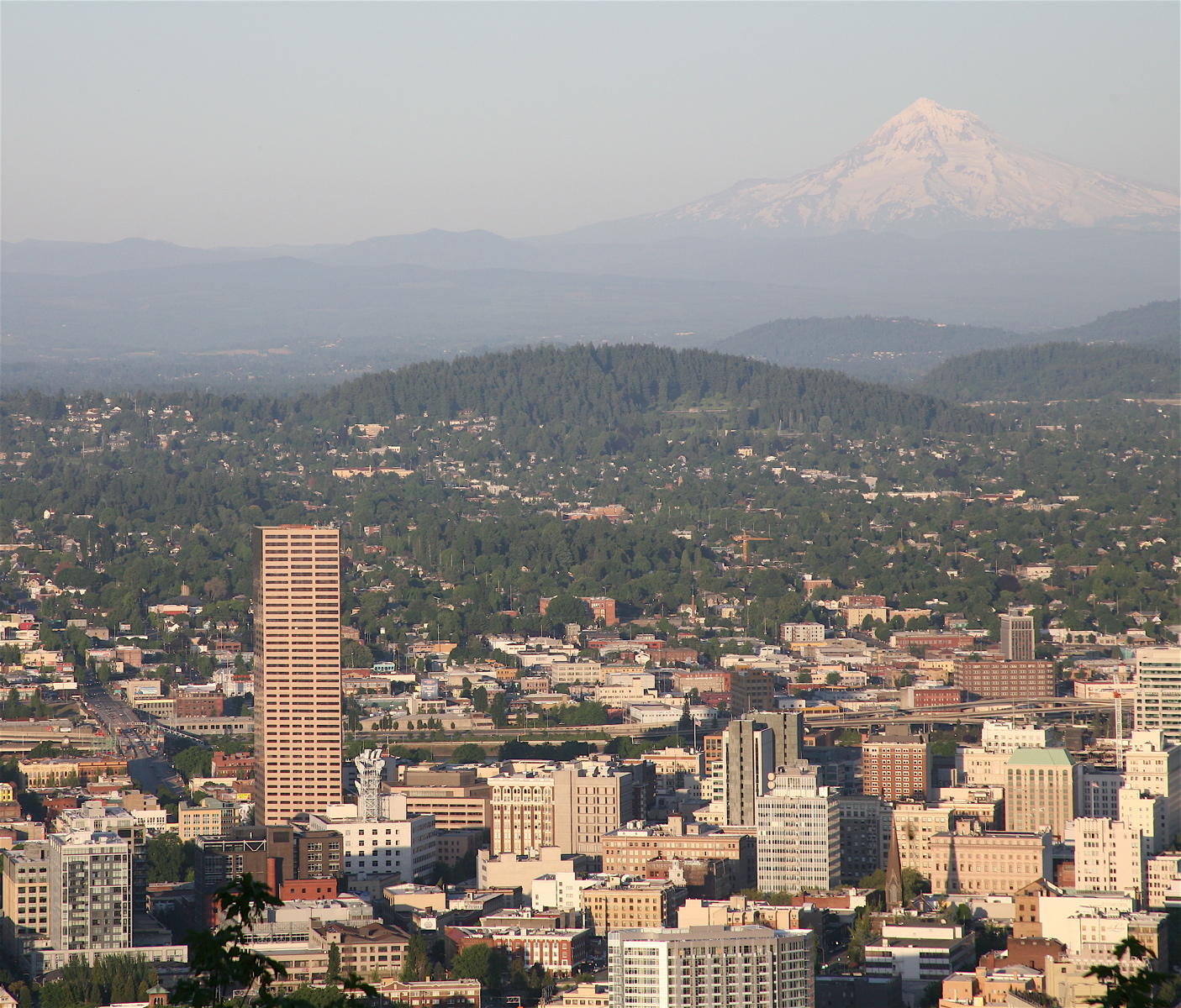
 View of Portland from Mount Tabor
 Gatehouse of the now-defunct Reservoir 2, on the National Register of Historic Places.
 Harvey W. Scott Statue in Mt. Tabor Park
See also
- Chauncey Hosford, an early owner of the property at the summit of Mt. Tabor
- Hawthorne District
References
- ^ McArthur, Lewis A.; Lewis L. McArthur (2003) [1928]. Oregon Geographic Names (Seventh Edition ed.). Portland, Oregon: Oregon Historical Society Press. ISBN 0-87595-277-1 (trade paperback), ISBN 0-87595-278-X (hardcover).
- ^ "Mount Tabor". Geographic Names Information System, U.S. Geological Survey. http://geonames.usgs.gov/pls/gnispublic/f?p=gnispq:3:::NO::P3_FID:1136814. Retrieved 2010-12-13.
- ^ "USGS topographic map centered at Mount Tabor". http://mapper.acme.com/?ll=45.51071,-122.59322&z=15&t=T.
- ^ a b "National Register Information System". National Register of Historic Places. National Park Service. 2009-03-13. http://nrhp.focus.nps.gov/natreg/docs/All_Data.html.
- ^ Charles A. Wood; Jűrgen Kienle (1990). Volcanoes of North America. Cambridge University Press. pp. 170–172.
- ^ "Guide to the Mount Tabor Neighborhood". http://www.movingtoportland.net/living_mounttabor.htm. Retrieved 2010-12-13.
- ^ Karl Samson (2010). Frommer's Oregon. Frommer's. p. 63. ISBN 9780470537718.
- ^ "Historic Districts in Multnomah County, Oregon". http://www.nationalregisterofhistoricplaces.com/or/Multnomah/districts.html.
- ^ "Oregon Historic Sites Database". Heritagedata.prd.state.or.us. http://heritagedata.prd.state.or.us/historic/index.cfm?do=v.dsp_siteSummary&resultDisplay=49479. Retrieved 2008-11-04.
- ^ "Oregon Historic Sites Database". Heritagedata.prd.state.or.us. http://heritagedata.prd.state.or.us/historic/index.cfm?do=v.dsp_siteSummary&resultDisplay=55582. Retrieved 2008-11-04.
- ^ "The Olmsteds in the Pacific Northwest: The Art of Landscape Design". http://www.halcyon.com/tmend/Olmsted.htm. Retrieved 20011-06-04.
- ^ http://www.encyclopedia.com/doc/1O1-RansomeErnestLeslie.html
- ^ Terpstra, Stan (December 2006). "Old friend returns to Mount Tabor Park". The Southeast Examiner.
- ^ a b c d Snyder, Eugene E. (1991). Portland Potpourri. Portland, Oregon: Binford & Mort. pp. 73–79. ISBN 083230493X.
- ^ "Skinny dipping incident calls reservoir security into question | Local News | kgw.com | News for Oregon and SW Washington". Kgw.com. Archived from the original on 2008-09-17. http://web.archive.org/web/20080917040814/http://www.kgw.com/news-local/stories/kgw_063008_news_skinny_dipping_mt_tabor_reservoir_.ddbf610.html. Retrieved 2011-06-04.
- ^ "Portland Parks & Recreation :: Mt Tabor Park". Portlandonline.com. http://www.portlandonline.com/parks/finder/index.cfm?action=ViewPark&PropertyID=275. Retrieved 2008-11-04.
- ^ "E. coli scare renews questions about covering reservoirs". Oregonlive.com. December 5, 2009. http://www.oregonlive.com/portland/index.ssf/2009/12/e_coli_scare_renews_questions.html.
- ^ "Portland reservoir urination raises few health or scientific concerns -- but it is pee". Oregonlive.com. June 16, 2009. http://www.oregonlive.com/portland/index.ssf/2011/06/portland_reservoir_urination_r.html.
External links
- Mount Tabor Park in the Oregon Encyclopedia
- Mount Tabor Cinder Cone, Portland, Oregon (USGS Cascades Volcanic Observatory)
- Friends of the Reservoirs
- Friends of Mount Tabor, a non-profit group founded in 2000
- Mount Tabor: Architectural Heritage, 1850–1930 (by Jan Caplener)
- The early years of Mount Tabor (by Grant Nelson)
- Closeup of the crater, the half-circle next to the parking lot
- Audio from March '07 news story on KPOJ, about traffic on Mount Tabor
- East Buttes Terraces and Wetlands Conservation Plan
U.S. National Register of Historic Places Topics Lists by states Alabama • Alaska • Arizona • Arkansas • California • Colorado • Connecticut • Delaware • Florida • Georgia • Hawaii • Idaho • Illinois • Indiana • Iowa • Kansas • Kentucky • Louisiana • Maine • Maryland • Massachusetts • Michigan • Minnesota • Mississippi • Missouri • Montana • Nebraska • Nevada • New Hampshire • New Jersey • New Mexico • New York • North Carolina • North Dakota • Ohio • Oklahoma • Oregon • Pennsylvania • Rhode Island • South Carolina • South Dakota • Tennessee • Texas • Utah • Vermont • Virginia • Washington • West Virginia • Wisconsin • WyomingLists by territories Lists by associated states Other  Category:National Register of Historic Places •
  Portal:National Register of Historic PlacesCategories:
- Historic districts in Oregon
- Historic districts in the United States
- Parks in Portland, Oregon
- Volcanoes of Oregon
- Mountains of Oregon
- Subduction volcanoes
- Cascade Volcanoes
- Cinder cones of the United States
- Extinct volcanoes
- Landforms of Multnomah County, Oregon
- National Register of Historic Places in Portland, Oregon


Wikimedia Foundation. 2010.