- Mountain formation
-
Mountain formation refers to the geological processes that underlie the formation of mountains. These processes are associated with large-scale movements of the earth's crust (plate tectonics).[1]
The formation of mountain ranges occurs by means of lateral movements as opposed to vertical ones. Mountain formation is related to plate tectonics. Folding, faulting, volcanic activity, igneous intrusion and metamorphism are all parts of the orogenic process of mountain building.[2]
The understanding of specific landscape features in terms of the underlying tectonic processes is called tectonic geomorphology, and the study of geologically young or ongoing processes is called neotectonics.[3]
Contents
Types of mountains
See also: List of mountain typesThere are three main types of mountains: volcanic, fold, and block.[4] A more detailed classification useful on a local scale predates plate tectonics and adds to the above categories.[5]
Volcanic mountains

 Mauna Loa lava flow; a shield volcano.
 Stratovolcanoes associated with a subduction (left) and a spreading ridge volcano (right). A hotspot volcano is center.[6]
 Elements of volcanoes in a volcanic arc system.
Movements of tectonic plates create volcanoes along the plate boundaries which erupt and form mountains. A volcanic arc system is a series of volcanoes that form near a subduction zone where the crust of a sinking oceanic plate melts.[7]
Most volcanoes occur in a band encircling the Pacific Ocean (the Pacific Ring of Fire), and in another that extends from the Mediterranean across Asia to join the Pacific band in the Indonesian Archipelago. The most important types of volcanic mountain are composite cones or "stratovolcanoes" (Vesuvius, Kilimanjaro and Mount Fuji are examples) and shield volcanoes (such as Mauna Loa on Hawaii, a hotspot volcano).[8][9]
A shield volcano has a gently sloping cone due to the low viscosity of the emitted material, primarily basalt. Mauna Loa is the classic example, with a slope of 4°-6°. (The relation between slope and viscosity falls under the topic of angle of repose.[10]) The composite volcano or stratovolcano has a more steeply rising cone (33°-40°),[11] due to the higher viscosity of the emitted material, and eruptions are more violent and less frequent than for shield volcanoes. Besides the examples already mentioned are Mount Shasta, Mount Hood and Mount Rainier.[12]
Fold mountains
See also: Fold (geology), Fold and thrust belt, and Fold mountain Zard-Kuh, a fold mountain in the central Zagros range of Iran.
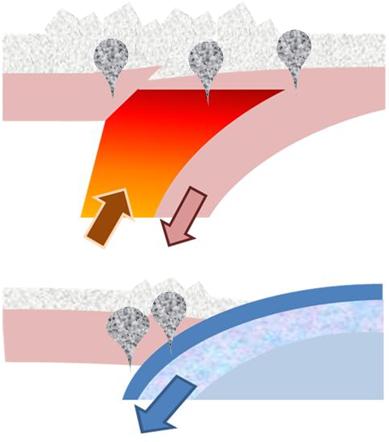
 Two processes creating mountains: Top:delamination by intrusion of hot asthenosphere; Bottom: Subduction of ocean crust.[13]
When plates collide or undergo subduction (that is ride one over another), the plates tend to buckle and fold, forming mountains. Most of the major continental mountain ranges are associated with thrusting and folding or orogenesis. Examples are the Jura and the Zagros mountains.[14]
Block mountains
Main article: Fault-block mountain Fault-block mountain of tilted type.[15]
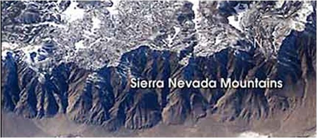
 Sierra Nevada Mountains (formed by delamination) as seen from the International Space Station.
When a fault block is raised or tilted, block mountains can result.[16] Higher blocks are called horsts and troughs are called grabens. A spreading apart of the surface causes tensional forces. When the tensional forces are strong enough to cause a plate to split apart, it will do so such that a center block will drop down relative to its flanking blocks.
An example is the Sierra Nevada Range, where delamination created a block 650 km long and 80 km wide that consists of many individual portions tipped gently west, with east facing slips rising abruptly to produce the highest mountain front in the continental United States.[17][18]
Models
See also: Prediction of volcanic activitySee also: GeomorphologyHotspot volcanoes
Hotspots are supplied by a magma source in the Earth's mantle called a mantle plume. Although originally attributed to a melting of subducted oceanic crust, recent evidence belies this connection.[19] The mechanism for plume formation remains a research topic.
Fault blocks
Several movements of the earth's crust that lead to mountains are associated with faults. These movements actually are amenable to analysis that can predict, for example, the height of a raised block and the width of an intervening rift between blocks using the rheology of the layers and the forces of isostasy. Early bent plate models predicting fractures and fault movements have evolved into today's kinematic and flexural models.[20][21]
Notes
- ^ Steven M. Stanley (2004). "Mountain building". Earth system history (2nd ed.). Macmillan. p. 207. ISBN 0716739070. http://books.google.com/books?id=jd01mugCR7EC&pg=PA207.
- ^ Robert J. Twiss, Eldridge M. Moores (1992). "Plate tectonic models of orogenic core zones". Structural Geology (2nd ed.). Macmillan. p. 493. ISBN 0716722526. http://books.google.com/books?id=14fn03iJ2r8C&pg=PA493.
- ^ Kurt Stüwe (2007). "§4.5 Geomorphology". Geodynamics of the lithosphere: an introduction (2nd ed.). Springer. p. 178. ISBN 3540712364. http://books.google.com/books?id=gwYcuMSUnxEC&pg=PA178.
- ^ "Chapter 6: Mountain building". Science matters: earth and beyond; module 4. Pearson South Africa. 2002. p. 75. ISBN 0798660597. http://books.google.com/books?id=qoZftjymxFsC&pg=PA75.
- ^ Andrew Goudie (2004). Encyclopedia of geomorphology; Volume 2. Routledge. p. 701. ISBN 0415327385. http://books.google.com/books?id=UHRU_6nUSR4C&pg=PA701.
- ^ Victor Schmidt, William Harbert (2003). Planet Earth and the New Geoscience (4th ed.). Kendall Hunt. pp. 46–47. ISBN 0787293555. http://books.google.com/books?id=VMR-e2cBCF4C&pg=PA46.
- ^ Stephen D Butz (2004). "Chapter 8: Plate tectonics". Science of Earth Systems. Thompson/Delmar Learning. p. 136. ISBN 0766833917. http://books.google.com/books?id=JB4ArbvXXDEC&pg=PA136.
- ^ John Gerrard (1990). "Types of volcano". Mountain environments: an examination of the physical geography of mountains. MIT Press. p. 194. ISBN 0262071282. http://books.google.com/books?id=jHnrVEyMhkQC&pg=PA194.
- ^ Robert Wayne Decker, Barbara Decker (2005). "Chapter 8: Hot spots". Volcanoes (4rth ed.). Macmillan. p. 113 ff. ISBN 0716789299. http://books.google.com/books?id=BilBFXIW5c4C&pg=PA113.
- ^ Arthur Holmes, Donald Duff (2004). Holmes Principles of Physical Geology (4th ed.). Taylor & Francis. p. 209. ISBN 0748743812. http://books.google.com/books?id=E6vknq9SfIIC&pg=PT226.
- ^ Transactions of the American Society of Civil Engineers, Volume 39. American Society of Civil Engineers. 1898. p. 62. http://books.google.com/books?id=ZlNDAAAAYAAJ&pg=PA62.
- ^ James Shipman, Jerry D. Wilson, Aaron Todd (2007). "Minerals, rocks and volcanoes". An Introduction to Physical Science (12th ed.). Cengage Learning. p. 650. ISBN 0618935967. http://books.google.com/books?id=1LvMLoaN0HQC&pg=PT670.
- ^ N. H. Woodcock, Robin A. Strachan (2000). "Chapter 12: The Caledonian Orogeny: a multiple plate collision". Geological history of Britain and Ireland. Wiley-Blackwell. p. 202, Figure 12.11. ISBN 0632036567. http://books.google.com/?id=dTkKn8Ufzd4C&pg=PA202&dq=%22origins+for+the+Caledonian+granites%22&cd=1#v=onepage&q=%22origins%20for%20the%20Caledonian%20granites%22&f=false.
- ^ Michael P Searle (2007). "Diagnostic features and processes in the construction and evolution of Oman-, Zagros-, Himalyan-, Karakoram-, and Tibetan type orogenic belts". In Robert D. Hatcher Jr., MP Carlson, JH McBride & JR Martinez Catalán. 4-D framework of continental crust. Geological Society of America. p. 41 ff. ISBN 0813712009. http://books.google.com/books?id=jD-zXhTfJuMC&pg=PA41.
- ^ Chris C. Park (2001). "Figure 6.11". The environment: principles and applications (2nd ed.). Routledge. p. 160. ISBN 0415217709. http://books.google.com/books?id=Ew3MBjbw4OAC&pg=PA160.
- ^ Scott Ryan (2006). "Figure 13-1". CliffsQuickReview Earth Science. Wiley. ISBN 0471789372. http://books.google.com/books?id=PV_BabxTTkcC&pg=PA94.
- ^ John Gerrard (1990-04-12). Reference cited. p. 9. ISBN 0262071282. http://books.google.com/books?id=jHnrVEyMhkQC&pg=PA9.
- ^ Lee, C.-T.; Yin, Q; Rudnick, RL; Chesley, JT; Jacobsen, SB (2000). "Osmium Isotopic Evidence for Mesozoic Removal of Lithospheric Mantle Beneath the Sierra Nevada, California". Science 289 (5486): 1912–6. doi:10.1126/science.289.5486.1912. PMID 10988067. http://www.geol.umd.edu/~rudnick/Webpage/Lee_2000_Science.pdf.
- ^ Y Niu & MJ O'Hara (2004). "Chapter 7: Mantle plumes are NOT from ancient oceanic crust". In Roger Hékinian, Peter Stoffers, Jean-Louis Cheminée. Oceanic hotspots: intraplate submarine magmatism and tectonism. Springer. p. 239 ff. ISBN 3540408592. http://books.google.com/books?id=K7L34ffaODwC&pg=PA239.
- ^ AB Watts (2001). "§7.2 Extensional tectonics and rifting". Isostasy and flexure of the lithosphere. Cambridge University Press. p. 295. ISBN 0521006007. http://books.google.com/books?id=CNkiZU7enWUC&pg=PA295.
- ^ GD Karner & NW Driscoll (1999). "Style, timing and distribution of tectonic deformation across the Exmouth Plateau, northwest Australia, determined from stratal architecture and quantitative basin modelling". In Conall Mac Niocaill, Paul Desmond Ryan. Continental tectonics. Geological society. p. 280. ISBN 1862390517. http://books.google.com/books?id=gpIY2unrObEC&pg=PA271.
See also
- Seamount
- Batholith
- Thrust fault
- Transform fault
- Continental collision
- Tectonics
- Orogeny
- Mantle plume
- Mantle convection
- Geology of the Yosemite area
External links
- NASA Goddard Planetary Geodynamics Laboratory: home page
- NASA Goddard Planetary Geodynamics Laboratory: Volcanology Research
- Plate tectonics pictures from UNR
- Rotating globe showing areas of earthquake activity
Shells Discontinuities Arguments Tectonic plates Major 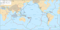
Minor Other Aegean Sea · Altiplano · Amurian · Anatolian · Apulian · Australian · Balmoral Reef · Banda Sea · Bird's Head · Burma · Capricorn · Caroline · Conway Reef · Easter · Explorer · Falklands · Futuna · Galapagos · Gonâve · Gorda · Greenland · Halmahera · Iberian · Indian · Iranian · Juan Fernández · Kerguelen · Kermadec · Kula · Madagascar · Manus · Maoke · Mariana · Molucca Sea · New Hebrides · Niuafo'ou · North Andes · North Bismarck · North Galapagos · Nubian · Okhotsk · Okinawa · Panama · Pelso · Philippine Mobile Belt · Rivera · Sangihe · Seychelles · Shetland · Solomon Sea · Somali · South Bismarck · South Sandwich · Sri Lanka · Sunda · Timor · Tisza · Tonga · Woodlark · YangtzeAll 
Volcanoes
Categories:- Mountains
- Orogeny
- Geological processes
- Plate tectonics
- Geological history of Earth


Wikimedia Foundation. 2010.