- Muggleswick, Stanhope and Edmundbyers Commons and Blanchland Moor
-
Muggleswick, Stanhope and Edmundbyers Commons and Blanchland Moor Site of Special Scientific Interest Country England Region North East District Derwentside
Wear Valley
TynedaleLocation NY990450
NY950520- coordinates 54°49′N 2°0′W / 54.817°N 2°W Area 9,118.12 ha (22,531 acres) Notification 1997 Management Natural England Area of Search County Durham Interest Biological 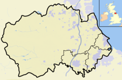
 Location of Muggleswick, Stanhope and Edmundbyers Commons and Blanchland Moor SSSI, Durham
Website: Map of site Muggleswick, Stanhope and Edmundbyers Commons and Blanchland Moor is a Site of Special Scientific Interest in County Durham and Northumberland, England. It consists of two separate areas, the larger—encompassing the upland areas of Muggleswick, Stanhope and Edmundbyers Commons—in the Derwentside and Wear Valley districts of north Durham, the smaller—Blanchland Moor—in the Tynedale district of south-west Northumberland.[1]
The site has one of the most extensive areas of dry heath in northern England. There are also areas of wet heath, acid grassland, flushes, relict juniper woodland and small areas of open water.
The dry heath is dominated by heather, Calluna vulgaris, and wavy hair-grass, Deschampsia flexuosa; the regionally rare bearberry, Arctostaphylos uva-ursi, is found on the higher parts of Blanchland Moor. Other noteworthy plants are the nationally scarce pale forget-me-not, Myosotis stolonifera, and the regionally rare round-leaved crowfoot, Ranunculus omiophyllus, and ivy-leaved bellflower, Wahlenbergia hederacea, all of which occur in the vicinity of streams, and the nationally scarce spring sandwort, Minuartia verna, one of a number of metallophytes that occur on old spoil heaps around disused lead-mines on Stanhope Common.[1]
As with the rest of the North Pennines moorlands, of which these areas form part, the site is home to nationally important breeding populations of a number of birds. Three species—merlin, Eurasian golden plover and short-eared owl—are listed in Annex 1 of the European Commission's Birds Directive as requiring special protection; the high density of merlin is particularly noteworthy. Other breeding species include red grouse, Eurasian curlew, common redshank, common snipe and dunlin, which are listed in the United Kingdom's Red Data Book (Birds).[1][2]
References
- ^ a b c "Muggleswick, Stanhope and Edmundbyers Commons and Blanchland Moor". English Nature. 1990. http://www.english-nature.org.uk/citation/citation_photo/2000173.pdf. Retrieved 29 July 2010.
- ^ Eaton, M A; A F Brown, D G Noble, A J Musgrove, R Hearn, N J Aebischer, D W Gibbons, A Evans and R D Gregory (2009). "Birds of Conservation Concern 3: the population status of birds in the United Kingdom, Channel Islands and the Isle of Man". British Birds 102: 296–341.
Backstone Bank and Baal Hill Woods • Baldersdale Woodlands • Bishop Middleham Quarry • Bollihope, Pikestone, Eggleston and Woodland Fells • Botany Hill • Bowes Moor • Bowlees and Friar House Meadows • Brasside Pond • Brignall Banks • Burnhope Burn • Butterby Oxbow • Cassop Vale • Castle Eden Dene • Causey Bank Mires • Charity Land • Close House Mine • Cornriggs Meadows • Cotherstone Moor • Crag Gill • Crime Rigg and Sherburn Hill Quarries • Dabble Bank • Derwent Gorge and Horsleyhope Ravine • Durham Coast • Fairy Holes Cave • Far High House Meadows • Fishburn Grassland • Foster's Hush • Frog Wood Bog • God's Bridge • Grains o' th' Beck Meadows • Green Croft and Langley Moor • Greenfoot Quarry • Hannah's Meadows • Hawthorn Dene • Hawthorn Quarry • Hell Kettles • Hesledon Moor East • Hesledon Moor West • Hexhamshire Moors • Hisehope Burn Valley • Hulam Fen • Hunder Beck Juniper • Kilmond Scar • Low Redford Meadows • Lune Forest • Mere Beck Meadows • Middle Crossthwaite • Middle Side and Stonygill Meadows • Middleton Quarry • Middridge Quarry • Moorhouse and Cross Fell • Muggleswick, Stanhope and Edmundbyers Commons and Blanchland Moor • Neasham Fen • Newton Ketton Meadow • Old Moss Lead Vein • Park End Wood • Pig Hill • Pike Whin Bog • Pittington Hill • Pow Hill Bog • Quarrington Hill Grasslands • Railway Stell West • Raisby Hill Grassland • Raisby Hill Quarry • Redcar Field • Rigg Farm and Stake Hill Meadows • Rogerley Quarry • Sherburn Hill • Shipley and Great Woods • Sleightholme Beck Gorge - The Troughs • Slit Woods • Stony Cut, Cold Hesledon • Teesdale Allotments • The Bottoms • The Carrs • Thrislington Plantation • Town Kelloe Bank • Trimdon Limestone Quarry • Tuthill Quarry • Upper Teesdale • Waldridge Fell • West Newlandside Meadows • West Park Meadows • West Rigg Open Cutting • Westernhope Burn Wood • Wingate Quarry • Witton-le-Wear • Yoden Village QuarryNeighbouring areas: Cleveland • Northumberland • Tyne and Wear Categories:- Sites of Special Scientific Interest in County Durham
- Sites of Special Scientific Interest in Northumberland

Wikimedia Foundation. 2010.