- Murrysville, Pennsylvania
-
Murrysville, Pennsylvania 
SealLocation within the state of Pennsylvania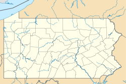
 Murrysville, Pennsylvania
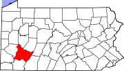
Coordinates: 40°26′5″N 79°39′24″W / 40.43472°N 79.65667°WCoordinates: 40°26′5″N 79°39′24″W / 40.43472°N 79.65667°W Country United States State Pennsylvania County Westmoreland Settled 1788 (as Franklin Township) Government – Mayor Robert J. Brooks – Chief Administrator James R Morrison Area – Total 37 sq mi (95.8 km2) Elevation 1,110 ft (338.3 m) Population (2000) – Total 18,872 Time zone Eastern (UTC-5) – Summer (DST) Eastern (UTC-4) Website www.murrysville.com Murrysville is a borough in Westmoreland County, Pennsylvania, United States. The population was 18,872 at the 2000 census. It became a home rule municipality in August 1976.[1]
Contents
Geography
Murrysville is located at 40°26′5″N 79°39′24″W / 40.43472°N 79.65667°W (40.434828, -79.656724)[2]. It is roughly 20 miles east of Pittsburgh, Pennsylvania on U.S. Route 22, just east of the county line that separates Westmoreland and Allegheny counties.
According to the United States Census Bureau, the borough had a total area of 36.9 square miles (96 km2), of which, 36.9 square miles (96 km2) of it is land and 0.03% is water.
Among the neighborhoods within Murrysville are Murrysville Heights, Heather Highlands, Franklin Estates, Dunningtown, Newlonsburg, Ringertown, Sardis, and White Valley. Murrysville surrounds, but does not include, the Borough of Export, which is a separate municipal entity.
Government
Murrysville is governed by a mayor (currently Robert Brooks) who is elected every two years and has administrative powers, and a seven member council, whose members are elected every four years and have legislative powers.[3]
Demographics
As of the census[4] of 2000, there were 18,872 people, 7,083 households, and 5,630 families residing in the borough. The population density was 511.0 people per square mile (197.3/km²). There were 7,396 housing units at an average density of 200.3 per square mile (77.3/km²). The racial makeup of the borough was 95.38% White, 0.61% African American, 0.05% Native American, 3.28% Asian, 0.01% Pacific Islander, 0.16% from other races, and 0.50% from two or more races. Hispanic or Latino of any race were 0.56% of the population.
There were 7,083 households out of which 34.5% had children under the age of 18 living with them, 71.8% were married couples living together, 5.5% had a female householder with no husband present, and 20.5% were non-families. 18.4% of all households were made up of individuals and 9.0% had someone living alone who was 65 years of age or older. The average household size was 2.63 and the average family size was 3.01.
Historical populations Census Pop. %± 1930 3,535 — 1940 3,797 7.4% 1950 4,937 30.0% 1960 8,517 72.5% 1970 12,244 43.8% 1980 16,036 31.0% 1990 17,240 7.5% 2000 18,872 9.5% source:[5] In the borough the population was spread out with 24.9% under the age of 18, 4.9% from 18 to 24, 24.3% from 25 to 44, 30.3% from 45 to 64, and 15.6% who were 65 years of age or older. The median age was 43 years. For every 100 females there were 97.9 males. For every 100 females age 18 and over, there were 93.1 males.
The median income for a household in the borough was $64,071, and the median income for a family was $72,740. Males had a median income of $58,553 versus $32,567 for females. The per capita income for the borough was $32,017. About 2.2% of families and 2.8% of the population were below the poverty line, including 3.1% of those under age 18 and 3.9% of those age 65 or over.
Education
Murrysville is within the Franklin Regional School District. The district operates five schools: three elementary (Sloan, Heritage, Newlonsburg), Franklin Regional Middle School, and Franklin Regional High School, with Dr. Ian P. Griffith as the districts Superintendent. Private schools include Mother of Sorrows Catholic School.
Notable people
- Julie Benz (born 1972), actress
- Jeremiah Burrell (1815–1856), Western Pennsylvania lawyer and judge
- Bobby Engram (born 1973), Seattle Seahawks wide receiver San Francisco 49ers Assistant offensive coordinator
- Ken Macha, Milwaukee Brewers manager
- Manu Narayan (born 1973), actor
- Candace Otto, Miss Pennsylvania 2003
- Tom Flynn (American football), defensive back for Green Bay Packers and New York Giants
- Jessica Warman (Born 1981), author
Local features
The Haymaker Gas Well in Murrysville was the nation's first commercial natural gas well. For some time, it remained the largest commercial gas well in the world.[6]
Since 1933, Murrysville has had a "tree sign" spelling out the word "Murrysville". The trees were landscaped to grow and form the letters by local Boy Scouts. The sign is situated on a large hill as one enters the borough from the Murrysville/Monroeville border, near U.S. Route 22. In 1947, the sign was featured in "Ripley's Believe It Or Not" as the world's largest arboreal sign.[7] (It is no longer the world's largest, or even the largest in the country; "Luecke", near San Antonio, Texas, is much larger.) The "Y" in the Murrysville sign points to the Haymaker Gas Well.
See also
- Westmoreland conservancy
References
- ^ Population Estimates Boundary Changes, United States Census Bureau, 2007-07-01. Accessed 2008-11-06.
- ^ "US Gazetteer files: 2010, 2000, and 1990". United States Census Bureau. 2011-02-12. http://www.census.gov/geo/www/gazetteer/gazette.html. Retrieved 2011-04-23.
- ^ Murrysville Municipal Government Information
- ^ "American FactFinder". United States Census Bureau. http://factfinder.census.gov. Retrieved 2008-01-31.
- ^ "Land Patterns" (PDF). Municipality of Murrysville. http://www.murrysvillegov.org/documents/comp_plan/appendix-a.pdf. Retrieved 2007-10-26.[dead link]
- ^ http://www.explorepahistory.com/hmarker.php?markerId=436
- ^ Cleary, Caitlin (2005-06-06). "Murrysville landmark is fading from view". Pittsburgh Post-Gazette. http://www.post-gazette.com/pg/05157/516504.stm.
External links
- Borough website
- Murrysville's official Community Magazine
- Murrysville Economic and Community Development Corporation
- The Murrysville Star
- Murrysville Business Directory
- News articles about the Murrysville tree sign and efforts to restore it: Pittsburgh Post-Gazette, February 16, 2006
- Penn-Franklin News, based in Murrysville
Municipalities and communities of Westmoreland County, Pennsylvania Cities Arnold | Greensburg | Jeannette | Latrobe | Lower Burrell | Monessen | New Kensington
Boroughs Adamsburg | Arona | Avonmore | Bolivar | Delmont | Derry | Donegal | East Vandergrift | Export | Hunker | Hyde Park | Irwin | Laurel Mountain | Ligonier | Madison | Manor | Mount Pleasant | Murrysville | New Alexandria | New Florence | New Stanton | North Belle Vernon | North Irwin | Oklahoma | Penn | Scottdale | Seward | Smithton | South Greensburg | Southwest Greensburg | Sutersville | Trafford‡ | Vandergrift | West Leechburg | West Newton | Youngstown | Youngwood
Townships Allegheny | Bell | Cook | Derry | Donegal | East Huntingdon | Fairfield | Hempfield | Ligonier | Loyalhanna | Mount Pleasant | North Huntingdon | Penn | Rostraver | St. Clair | Salem | Sewickley | South Huntingdon | Unity | Upper Burrell | Washington
CDPs Unincorporated
communitiesAcme | Boquet | Calumet | Hannastown | Hopewell | Hutchinson | Kecksburg | Lloydsville | Luxor | Moween | Norvelt | Ruffs Dale | Southwest | Stahlstown | Standard Shaft | Salina | Turkeytown | United
Ghost town Footnotes ‡This populated place also has portions in an adjacent county or counties
Categories:- Home Rule Municipalities in Pennsylvania
- Boroughs in Westmoreland County, Pennsylvania
- Populated places established in 1788
- Pittsburgh metropolitan area


Wikimedia Foundation. 2010.