- Rosarito Beach Municipality
-
Rosarito Beach Muncipality — Municipality — Municipio de Playas de Rosarito
Municipality of Rosarito Beach
SealMotto: A Horizon of Possibilities Location of Rosarito Beach Municipality in Baja California.
Coordinates: 32°20′32″N 117°03′22″W / 32.34222°N 117.05611°WCoordinates: 32°20′32″N 117°03′22″W / 32.34222°N 117.05611°W Country Mexico State Baja California Municipal seat Rosarito Largest city Rosarito Municipality established June 29, 1995 Government – Municipal president Hugo Torres (  PRI)
PRI)Area – Total 513.32 km2 (198.2 sq mi) Population (2010) – Total 90,668 – Density 176.6/km2 (457.5/sq mi) Data source: INEGI 2010 Census Time zone PST (UTC-8) – Summer (DST) PDT (UTC-7) INEGI code 005 Website (Spanish) Ayuntamiento de Playas de Rosarito Source: Enciclopedia de los Municipios de México Rosarito Beach Municipality (Spanish: Municipio de Playas de Rosarito) is located in the northwestern part of the Mexican state of Baja California comprising part of the Tijuana metropolitan area. It lies just south of the city of Tijuana. Its municipal seat is the city of Rosarito. According to the 2010 census, the municipality had a population of 90,668 inhabitants. Its area is 513.32 km² (198.19 sq mi).
Contents
Buroughs
- Primo Tapia
- Plan Libertador
Major communities
The largest localities (cities, towns, and villages) are:[1]
Name 2010 Census Population Rosarito 65,278 Ampliación Ejido Plan Libertador 5,906 Primo Tapia 4,921 Ciudad Morelos 2,040 Colinas del Sol 1,361 Santa Anita 1,284 Total Municipality 90,668 Other localities
- Puerto Nuevo (pop. 135)
References
- (Spanish) Link to tables of population data from the 2005 Census, INEGI: Instituto Nacional de Estadística, Geografía e Informática.
- (Spanish) Playas de Rosarito, Enciclopedia de los Municipios de México, Instituto Nacional Para el Federalismo y el Desarrollo Municipal, SEGOB. Accessed on line November 15, 2007.
External links
- (Spanish) Ayuntamiento de Playas de Rosarito Official government website.
- (English) Official government tourism office website
- (English) Las Rocas Resort & Spa
Articles relating to Rosarito Beach Municipality  State of Baja California
Major cities 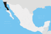
Regions Baja California Desert · Baja California Gold Coast · Colorado River Delta · Sierra Juárez and San Pedro Mártir pine-oak forests
Metro areas Municipalities Ensenada · Mexicali · Rosarito Beach · Tecate · Tijuana
San Diego–Tijuana History • Geography • Geology • Populace • Economy • Transportation • Education • Communication • Other Infrastructure • CultureCounties and
MunicipalitiesRosarito Beach • San Diego • Tecate • Tijuana
Global cities Large cities
100k - 250kCities and towns
20k - 99kCoronado • El Cajon • El Refugio • Encinitas • Fallbrook • Imperial Beach • La Joya • La Mesa • La Presa • Lemon Grove • National City • Pórticos de San Antonio • Poway • Rancho San Diego • Rosarito Beach • San Marcos • Santee • Spring Valley • Tecate • Terrazas del Valle • VistaCities and towns
10k-19kAlpine • Bonita • Bostonia • Casa de Oro-Mount Helix • Las Delicias • Ramona • Rancho San Diego • San Diego Country Esates • Solana Beach • Villa del Campo • Villa del Prado • Winter GardensBodies of water Agua Hedionda Lagoon • Batiquitos Lagoon • El Capitan Lake • Abelardo L. Rodriguez • Lake Hodges • Lake Sutherland • Lower Otay Reservoir • Loveland Reservoir • Mission Bay • Pacific Ocean • San Elijo Lagoon • San Diego Bay • San Vicente Reservoir • Sweetwater Reservoir • Tijuana River EstuarySub-regions Anza Borrego • Coronado Peninsula • Cuyamaca • East County • Mountain Empire • North County • Palm Valley • Rosarito • San Diego • South Bay • Tecate • TijuanaMajor cities 
Municipalities Ensenada Municipality · Rosarito Beach Municipality · Tijuana Municipality
Metro areas Bodies of water Tijuana River · Bahia de Todos Santos
Categories:- Rosarito Beach Municipality
- Municipalities of Baja California
- Mexico geography stubs


Wikimedia Foundation. 2010.