- Mädelegabel
-
Mädelegabel 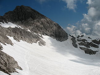
The Mädelegabel from the south. Below: the Schwarzmilzferner (2009)
Height 2,645 m (8,678 ft) Location Bavarian / Tyrolean border Range Central ridge, Allgäu Alps Isolation 0.4 km → Hochfrottspitze Prominence 81 m ↓ Windgap with the Hochfrottspitze → Hochfrottspitze Coordinates 47°18′00″N 10°17′45″E / 47.3°N 10.29583°ECoordinates: 47°18′00″N 10°17′45″E / 47.3°N 10.29583°E 

First climbed 1818 Easiest route from the Heilbronn Way The Mädelegabel is a 2,645 metre high mountain, made of dolomite, in the Allgäu Alps near Oberstdorf. It is one of the best-known and most-climbed high peaks in the German Alps, Within the Allgäu Alps it is the fourth-higest summit, with rock faces up to 400 metres high. Together with the Trettachspitze and the Hochfrottspitze it forms the famous triumvirate of peaks on the main crest of the Allgäu. Its name comes from Mähder - a mown mountain pasture in the vicinity - and gabel from the appearance of the triumvirate to the north which recalls a fork (German: Gabel). Originally the Mädelegabel was the name for all three peaks of the triumvirate; only later were they distinguished from one another by name.
The border between Bavaria and Austria runs along the mountain ridge. On its southeastern slopes is the Schwarzmilzferner, a small glacier.
The extremely popular Heilbronn Way (Heilbronner Weg) runs past the summit, below it and to the south.
Contents
Ascent
The Mädelegabel can be quickly reached from the Heilbronn Way. The route branches off the Heilbronn Way on the ridge just above the Schwarmilzferner glacier and follows the marked path, taking about 30 minutes to reach the summit. It involves a UIAA grade I climb which is not difficult as it is not very exposed and the going, on solid rock, is firm. As a result, the mountain receives a lot of visitors. Bases that can be used for the ascent include the Waltenberger Haus (2.5 hours to the summit), Kemptner Hut (2.75 h) and Rappensee Hut (5 h). The Mädelegabel is a popular spring ski tour starting from the Lech valley and overnighting if need be at the Kemptner Hut. The mountain was probably first climbed during survey work in 1818/19 which was completed by the border commission in 1835. It was certainly conquered in 1852 by Otto Sendtner on today's normal ascent.[1]
Gallery
-

Summit cross
-

The Mädelgegabel group from the Guggersee to the northwest
-

The Mädelegabel (left) and Trettachspitze (right) from the east
-

View of the Mädelegabel (2nd peak from right). Left: the Kratzer and left in front of it, the Kemptner Hut
References
- ^ Ernst Zettler, Heinz Groth: Alpenvereinsführer - Allgäuer Alpen. 12., completely new, updated edition. Bergverlag Rudolf Rother, Munich 1985, ISBN 3-7633-1111-4 (p. 204).
Sources
- Ernst Enzenperger: Die Gruppe der Mädelegabel, Munich, Jos. Köselsche Buchhandlung, 1909
- Thaddäus Steiner: Die Flurnamen der Gemeinde Oberstdorf im Allgäu, Vol. II, Selbstverlag des Verbandes für Flurnamenforschung, München 1972
- Alpenvereinskarte 1:25,000, Sheet 2/1, Allgäuer- Lechtaler Alpen, West
Weblinks
Categories:- Two-thousanders
- Allgäu Alps
- Mountains of the Alps
- Mountains of Bavaria
- Mountains of Tyrol
- Oberallgäu district
-


Wikimedia Foundation. 2010.