- NOAA-7
-
NOAA-7 (or NOAA-C) was launched on 23 June 1981 from Vandenberg Air Force Base, California. NOAA-7 was launched atop an Atlas F rocket. Launch occurred at 3:53am PST. Its mass was 588.9 kilograms (1,298 lb). It had an orbital time of 102 minutes at an inclination of 98.9, a perigee of 845 kilometres (456 nmi) and an apogee of 863 kilometres (466 nmi). NOAA-7 was an operational meteorological satellite for use in the National Operational Environmental Satellite System (NOESS), which is part of the National Oceanic and Atmospheric Administration. It was used to support the Global Atmospheric Research Program (GARP) during 1978-1984.
The satellite design provided an economical and stable sun synchronous platform for advanced operational instruments to measure the Earth's atmosphere, its surface and cloud cover, and the near space environment. The primary sensors included an Advanced Very High Resolution Radiometer (AVHRR) and a TIROS Operational Vertical Sounder (TOVS). There were a number of secondary experiments on-board NOAA-7. These include a Space Environment Monitor (SEM) and a Data Collection and Platform Location System (DCPLS). The United States Air Force also provided a contamination monitor to assess contamination sources, levels and effects for consideration on future spacecraft.
NOAA-7 was based upon the Block 5D spacecraft bus developed for the U.S. Air Force. The satellite was capable of maintaining an earth-pointing accuracy of better than plus or minus 0.1 degree with a motion rate of less than 0.035 deg/second.
External links
TIROS satellites TIROS 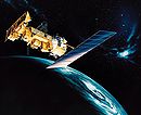
TOS ITOS TIROS-N Adv. TIROS-N Categories:- Weather satellites
- 1960 in spaceflight
- United States spacecraft stubs

Wikimedia Foundation. 2010.