- New York State Route 288
-
NYS Route 288
Noeltner Road Route information Maintained by NYSDOT Length: 2.39 mi[4] (3.85 km) Existed: early 1940s[1][2] – April 1, 1981[3] Major junctions South end:  NY 161 in Glen
North end:  NY 5S in Glen
Location Counties: Montgomery Highway system Numbered highways in New York
Interstate • U.S. • N.Y. (former) • Reference • County←  NY 287
NY 289  →
→New York State Route 288 (NY 288) was a north–south state highway in Montgomery County, New York, in the United States. It extended for 2.39 miles (3.85 km) as Noeltner Road through a rural portion of the town of Glen, serving as a connector between NY 161 east of the hamlet of Glen and NY 5S east of the hamlet of Auriesville. NY 288 was assigned in the early 1940s and existed until 1981 when ownership and maintenance of the road was transferred to Montgomery County. The NY 288 designation was subsequently removed, and its former routing became County Route 164 (CR 164).
Contents
Route description
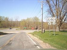 The former north end of NY 288 at NY 5S in Glen
NY 288 began 1.5 miles (2.4 km) east of the hamlet of Glen at a Y-shaped intersection with NY 161 in the town of Glen. From there, it headed to the northeast, following the two-lane Noeltner Road on a linear alignment for roughly 1.3 miles (2.1 km) across rolling, open fields. It broke from the straight path near a junction with CR 120, turning northward into a brief but dense wooded area. The route continued through the narrow forest to a more open area just south of the Mohawk River and the New York State Thruway, where it ended at a junction with NY 5S east of the hamlet of Auriesville.[5][6] Just southeast of the intersection is the National Shrine of the North American Martyrs, also known as the Auriesville Shrine.[7]
History
NY 288 was assigned in the early 1940s.[1][2] The route remained intact until April 1, 1981, when ownership and maintenance of the route was transferred from the state of New York to Montgomery County as part of a highway maintenance swap between the two levels of government.[3] The NY 288 designation was removed as a result[8] and its former routing became CR 164.[4]
Major intersections
The entire route was in Glen, Montgomery County.
Mile[4] Destinations Notes 0.00 NY 1612.39 NY 5SHamlet of Auriesville 1.000 mi = 1.609 km; 1.000 km = 0.621 mi References
- ^ a b Esso (1940). New York (Map). Cartography by General Drafting.
- ^ a b Esso (1942). New York with Pictorial Guide (Map). Cartography by General Drafting.
- ^ a b New York State Legislature. "New York State Highway Law § 341". http://public.leginfo.state.ny.us/LAWSSEAF.cgi?QUERYTYPE=LAWS+&QUERYDATA=$$HAY341$$@TXHAY0341+&LIST=LAW+&TARGET=VIEW. Retrieved February 20, 2011.
- ^ a b c "Montgomery County Inventory Listing" (CSV). New York State Department of Transportation. March 2, 2010. https://www.nysdot.gov/divisions/engineering/technical-services/hds-repository2/INV_2010-03-02_montgomery.csv. Retrieved February 20, 2011.
- ^ Yahoo! Inc. Yahoo! Maps – overview map of former NY 288 (Map). Cartography by NAVTEQ. http://maps.yahoo.com/#mvt=h&lat=42.912325&lon=-74.309265&zoom=15&q1=42.896464%2C-74.315716&q2=42.928209%2C-74.304966. Retrieved February 20, 2010.
- ^ State of New York (1981). I Love New York Tourism Map (Map). Cartography by Rand McNally and Company.
- ^ United States Geological Survey (1980). Tribes Hill Quadrangle – New York (Map). 1:24,000. 7.5 Minute Series (Topographic). http://www.nysgis.state.ny.us/gisdata/quads/drg24/usgspreview/index.cfm?code=o42074h3. Retrieved February 20, 2011.
- ^ New York State Department of Transportation (January 2009) (PDF). Official Description of Highway Touring Routes, Bicycling Touring Routes, Scenic Byways, & Commemorative/Memorial Designations in New York State. https://www.nysdot.gov/divisions/operating/oom/transportation-systems/repository/2009%20tour-bk.pdf. Retrieved January 3, 2010.
External links
Categories:- Former state highways in New York
- Transportation in Montgomery County, New York


Wikimedia Foundation. 2010.