- Al-Nabi Yusha'
-
Al-Nabi Yusha' 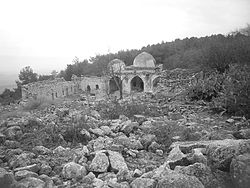
Nebi Yusha shrine in 2009
 Al-Nabi Yusha'
Arabic النبي يوشع Name Meaning "the prophet Joshua"[1] District Safad Coordinates 33°06′46.18″N 35°33′21.94″E / 33.1128278°N 35.5560944°ECoordinates: 33°06′46.18″N 35°33′21.94″E / 33.1128278°N 35.5560944°E Population 70[2] (1945) Area 3,617 dunums Date of depopulation May 16, 1948[3] Cause(s) of depopulation Military assault by Yishuv forces Current localities Ramot Naftali Al-Nabi Yusha' (Arabic: النبي يوشع was a small Lebanese [4] village in the Galilee situated 17 kilometers to the northeast of Safad, with an elevation of 375 meters above sea level. It became part of the Palestine Mandate under British control from 1923 until 1948, when it was depopulated during the 1948 Arab-Israeli War. The village is surrounded by forest land overlooking the Hula Valley.
Contents
History
During the late eighteenth century, a family known as al-GhuI established the shrine for Nabi Yusha’ ("Prophet Joshua"), which included a mosque and a building for visitors, as an act of devotion. This family, also called the "servants of the shrine," numbered about fifty and were the first to settle the site; they cultivated the surrounding land, and the place subsequently evolved into a village.[5]
The population of the village was Shi'a Muslim.[6] At the end of World War I it was under French control, and the 1920 boundary agreement between Britain and French placed it in Lebanon.[6] At the time of the census conducted by the French in 1921, the villagers were granted Lebanese citizenship.[7] However the Boundary Commission established by the 1920 agreement shifted the border, leaving the village in Palestine.[6] Transfer of control to the British authorities was not complete until 1924.[8]
During the Mandate period, the British built a police station in the village.[5] The people of al-Nabi Yusha’, all of whom were Shia Muslims, held an annual mawsim, or pilgrimage and festival on the fifteenth of the month Sha'aban (the eighth month of the Islamic calendar). The Mawsim was similar to that of the Al-Nabi Rubin, Ramla, festival.[5]
The village was home to 52 residents in 1931 (12 households), growing to 70 in 1945, and 81 (18 households) by 1948 when it was depopulated. The village occupied an area of 3,617 dunams, all private except for a 1 dunam public land.[2] In 1944/45 the village had 640 dunams of land used for cereals.[9][5]
 Nebi Yusha police fortress, 1948
1948 war, and aftermath
Al-Nabi Yusha' was depopulated on May 16, during the 1948 Arab-Israeli War under Operation Yiftach led by Israeli army officer Yigal Allon who later became a key Zionist figure. Most of its residents ended up in refugee camps in Lebanon and Syria. In 1998, the decedents of Al-Nabi Yusha' refugees were estimated at 499.
The Israeli moshav Ramot Naftali was established in 1945 south of the village, and since 1948 includes Al-Nabi Yusha' land. It is located close to the border between Al-Nabi Yusha' and the lands of Mallaha.[5][10]
The Palestinian historian Walid Khalidi described the village remains in 1992 as: "The site has been fenced in with barbed wire and is buried under rubble, making access difficult. However, some evidence of the village remains: fragments of houses, tombs in the village's cemetery, and the shrine of al-Nabi Yusha'. The two domes and arched entrance of the main part of the shrine are still intact, but the thick stone walls of the rooms attached to it are broken and the entire complex of buildings is neglected; weeds sprouts from the roof. The village site is surrounded by fig trees and cactuses,. The flat lands around the site are planted by Israeli farmers with apple trees, while the sloping parts are wooded or used as pasture."[11] The shrine was surveyed by the British School of Archaelology in 1994, who described it as rectangular structure formed around a courtyard, aligned north-south, which was entered through a gateway on the north end. The principal rooms were at the south end of the courtyard, with two major domed chambers, of which the west chamber was found to be the oldest in the whole shrine complex.[12]
See also
- List of Arab towns and villages depopulated during the 1948 Arab-Israeli War
- Metzudat Koach
- Metawali
- Seven Lebanese Villages
References
- ^ Palmer, 1881, p.92
- ^ a b Hadawi, 1970, p.70
- ^ Morris, 2004, p. xvi, village #26. Also gives cause of depopulation.
- ^ http://nowlebanon.com/Library/Files/EnglishDocumentation/Other%20Documents/The_Seven_Villages-paper-final2.pdf
- ^ a b c d e Khalidi, 1992, p. 481
- ^ a b c Asher Kaufman (2006). "Between Palestine and Lebanon: Seven Sahi'i villages as a case study of boundaries, identities and conflict". Middle East Journal 60: pp. 685–706.
- ^ Khalid Sindawi (2008). "Are there any Shi'ite Muslims in Israel?". Holy Land Studies 2: pp. 183–199.
- ^ Gideon Biger (2004). The boundaries of modern Palestine, 1840-1947. Routledge. p. 134. ISBN 978-0-7146-5654-0. http://books.google.com/?id=jC9MbKNh8GUC.
- ^ Hadawi, 1970, p.120
- ^ Morris, 2004, p. 361-2
- ^ Khalidi, 1992, p. 481-2
- ^ Petersen, 2002, p.236-8
Bibliography
- Hadawi, Sami (1970). Village Statistics of 1945: A Classification of Land and Area ownership in Palestine. Palestine Liberation Organization Research Center. http://www.palestineremembered.com/Articles/General-2/Story3150.html
- Khalidi, Walid (1992). All That Remains: The Palestinian Villages Occupied and Depopulated by Israel in 1948. Washington D.C.: Institute for Palestine Studies. ISBN 0-88728-224-5
- Morris, Benny (2004). The Birth of the Palestinian Refugee Problem Revisited. Cambridge University Press. ISBN 0-521-00967-7
- al-Qawuqji, Fauzi (1972): Memoirs of al-Qawuqji, Fauzi in Journal of Palestine Studies
- "Memoirs, 1948, Part I" in 1, no. 4 (Sum. 72): 27-58., dpf-file, downloadable
- "Memoirs, 1948, Part II" in 2, no. 1 (Aut. 72): 3-33., dpf-file, downloadable
- Lamb, Franklin. Completing The Task Of Evicting Israel From Lebanon 2009-06-02
- Palmer, E. H. (1881): The survey of Western Palestine: Arabic and English name lists collected during the survey by Lieutenants Conder and Kitchener, R. E. Transliterated and explained by E.H. Palmer.
- Petersen, Andrew (2002): A Gazetteer of Buildings in Muslim Palestine: Volume I (British Academy Monographs in Archaeology) p. 235-7
- Danny Rubinstein (06/08/2006). "The Seven Lost Villages". Haaretz. http://www.haaretz.com/hasen/pages/ShArt.jhtml?itemNo=746274. Retrieved 2009-06-02.
External links
- Welcome To al-Nabi Yusha', Palestine Remembered
- al-Nabi Yusha', at Khalil Sakakini Cultural Center
- Al-Nabi Yusha’, Dr. Khalil Rizk.
- UN map of the 1947 plan
- The Destroyed Palestinian Villages on Google Earth
Arab towns and villages depopulated during the 1948 Palestine War Acre al-Amqa · Arab al-Samniyya · al-Bassa · al-Birwa · al-Damun · Dayr al-Qassi · al-Ghabisiyya · Iqrit · Iribbin · Jiddin · al-Kabri · Kafr 'Inan · Kuwaykat · al-Manshiyya · al-Mansura · Mi'ar · al-Nabi Rubin · al-Nahr · al-Ruways · Suhmata · al-Sumayriyya · Suruh · al-Tall · Tarbikha · Umm al-Faraj · al-Zeeb
Baysan Arab al-'Arida · Arab al-Bawati · Arab al-Safa · al-Ashrafiyya · al-Bira · Beisan · Danna · Farwana · al-Fatur · al-Ghazzawiyya · al-Hamidiyya · al-Hamra · Jabbul · Kafra · Kawkab al-Hawa · al-Khunayzir · Masil al-Jizl · al-Murassas · Qumya · al-Sakhina · al-Samiriyya · Sirin · Tall al-Shawk · al-Taqa · al-Tira · Umm 'Ajra · Umm Sabuna, Khirbat · Yubla · Zab'a · al-Zawiya
Beersheba Gaza Arab Suqrir · Barbara · Barqa · al-Batani al-Gharbi · al-Batani al-Sharqi · Bayt 'Affa · Bayt Daras · Bayt Jirja · Bayt Tima · Bil'in · Burayr · Dayr Sunayd · Dimra · al-Faluja · Hamama · Hatta · Hiribya · Huj · Hulayqat · Ibdis · Iraq al-Manshiyya · Iraq Suwaydan · Isdud · al-Jaladiyya · al-Jiyya · Julis · al-Jura · Jusayr · Karatiyya · Kawfakha · Kawkaba · al-Khisas · al-Masmiyya al-Kabira · al-Masmiyya al-Saghira · al-Muharraqa · Najd · Ni'ilya · Qastina · al-Sawafir al-Gharbiyya · al-Sawafir al-Shamaliyya · al-Sawafir al-Sharqiyya · Simsim · Summil · Tall al-Turmus · Yasur
Haifa Abu Shusha · Abu Zurayq · Arab al-Fuqara · Arab al-Nufay'at · Arab Zahrat al-Dumayri · 'Atlit · Ayn Ghazal · Ayn Hawd · Balad ash-Sheikh · Barrat Qisarya · Burayka · al-Burj · al-Butaymat · Daliyat al-Rawha' · al-Dumun · al-Ghubayya al-Fawqa · al-Ghubayya al-Tahta · Hawsha · Ijzim · Jaba' · al Jalama · Kabara · al-Kafrayn · Kafr Lam · al-Kasayir · Khubbayza · Lid · al-Manara · al-Mansi · al-Mansura · al-Mazar · Naghnaghiya · Qamun · Qannir · Qira · Qisarya · Qumbaza · al-Rihaniyya · Sabbarin · al-Sarafand · Khirbat al-Sarkas · Khirbat Sa'sa' · al-Sawamir · Khirbat al-Shuna · al-Sindiyana · al-Tantura · al-Tira · Umm al-Shawf · Umm al-Zinat · Wa'arat al-Sarris · Wadi Ara · Yajur
Hebron 'Ajjur · Barqusya · Bayt Jibrin · Bayt Nattif · al-Dawayima · Deir al-Dubban · Dayr Nakhkhas · Kudna · Mughallis · al-Qubayba · Ra'na · Tell es-Safi · Umm Burj · az-Zakariyya · Zayta · Zikrin
Jaffa al-'Abbasiyya · Abu Kabir · Abu Kishk · Bayt Dajan · Biyar 'Adas · Fajja · al-Haram · Ijlil al-Qibliyya · Ijlil al-Shamaliyya · al-Jammasin al-Gharbi · al-Jammasin al-Sharqi · Jarisha · Kafr 'Ana · al-Khayriyya · al-Mas'udiyya · al-Mirr · al-Muwaylih · Rantiya · al-Safiriyya · Salama · Saqiya · al-Sawalima · al-Shaykh Muwannis · Yazur
Jerusalem Allar · Aqqur · Artuf · Bayt 'Itab · Bayt Mahsir · Bayt Naqquba · Bayt Thul · Bayt Umm al-Mays · al-Burayj · Dayr Aban · Dayr 'Amr · Dayr al-Hawa · Dayr Rafat · Dayr al-Shaykh · Deir Yassin · Ayn Karim · Ishwa · Islin · Ism Allah · Jarash · al-Jura · Kasla · al-Lawz · Lifta · al-Maliha · Nitaf · al-Qabu · Qalunya · al-Qastal · Ras Abu 'Ammar · Sar'a · Saris · Sataf · Sheikh Badr · Suba · Sufla · al-Tannur · al-'Umur · al-Walaja
Jenin Nazareth Indur · Ma'alul · al-Mujaydil · Saffuriyya
Ramla Abu al-Fadl · Abu Shusha · Ajanjul · Aqir · Barfiliya · al-Barriyya · Bashshit · Bayt Far · Bayt Jiz · Bayt Nabala · Bayt Shanna · Bayt Susin · Bir Ma'in · Bir Salim · al-Burj · al-Buwayra · Daniyal · Dayr Abu Salama · Dayr Ayyub · Dayr Muhaysin · Dayr Tarif · al-Duhayriyya · al-Haditha · Idnibba · Innaba · Jilya · Jimzu · Kharruba · al-Khayma · Khulda · al-Kunayyisa · al-Latrun · Lydda · al-Maghar · Majdal Yaba · al-Mansura · al-Mukhayzin · al-Muzayri'a · al-Na'ani · an-Nabi Rubin · Qatra · Qazaza · al-Qubab · al-Qubayba · Qula · Ramla · Sajad · Salbit · Sarafand al-Amar · Sarafand al-Kharab · Saydun · Shahma · Shilta · al-Tina · al-Tira · Umm Kalkha · Wadi Hunayn · Yibna · Zakariyya · Zarnuqa
Safad Abil al-Qamh · al-'Abisiyya · 'Akbara · Alma · Ammuqa · Arab al-Shamalina · Arab al-Zubayd · Ayn al-Zaytun · Baysamun · Biriyya · al-Butayha · al-Buwayziyya · Dallata · al-Dawwara · Dayshum · al-Dirbashiyya · al-Dirdara · Fara · al-Farradiyya · Fir'im · Ghabbatiyya · Ghuraba · al-Hamra' · Harrawi · Hunin · al-Husayniyya · Jahula · al-Ja'una · Jubb Yusuf · Kafr Bir'im · al-Khalisa · Khan al-Duwayr · Karraza, Khirbat · al-Khisas · Khiyam al-Walid · Kirad al-Baqqara · Kirad al-Ghannama · Lazzaza · Madahil · Al-Malkiyya · Mallaha · al-Manshiyya · al-Mansura · Mansurat al-Khayt · Marus · Meiron · al-Muftakhira · Mughr al-Khayt · al-Muntar · al-Nabi Yusha' · al-Na'ima · Qabba'a · Qadas · Qaddita · Qaytiyya · al-Qudayriyya · al-Ras al-Ahmar · Sabalan · Safsaf · Saliha · al-Salihiyya · al-Sammu'i · al-Sanbariyya · Sa'sa' · al-Shawka al-Tahta · al-Shuna · Taytaba · Tulayl · al-'Ulmaniyya · al-'Urayfiyya · al-Wayziyya · Yarda, Safad · al-Zahiriyya al-Tahta · al-Zanghariyya · al-Zawiya · al-Zuq al-Fawqani · al-Zuq al-Tahtani
Tiberias Awlam · al-Dalhamiyya · Ghuwayr Abu Shusha · Hadatha · al-Hamma · Hittin · Kafr Sabt · Lubya · Ma'dhar · al-Majdal · al-Manara · al-Manshiyya · al-Mansura · Nasir al-Din · Nimrin · al-Nuqayb · Samakh · al-Samakiyya · al-Samra · al-Shajara · al-Tabigha · al-'Ubaydiyya · al-Wa'ra al-Sawda', Khirbat · Yaquq
Tulkarm Khirbat Bayt Lid · Bayyarat Hannun · Fardisya · Ghabat Kafr Sur · al Jalama · Kafr Saba · al-Majdal · al-Manshiyya · Miska · Qaqun · Raml Zayta · Tabsur · Umm Khalid · Wadi al-Hawarith · Wadi Qabbani · al-Zabadida · Khirbat Zalafa
Categories:- Villages depopulated during the Arab–Israeli conflict
- District of Safad
- Palestinian shrines
- Tegart forts


Wikimedia Foundation. 2010.