- HaBesor Stream
-
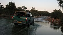 Tze'elim bridge on Besor river (June 20, 2007)
HaBesor (Hebrew: נחל הבשור, Nahal HaBesor) is a wadi in southern Israel. The stream begins at Mount Boker (near Sde Boker), and spills into the Mediterranean Sea near Deir al-Balah in the Gaza Strip, where it is called Wadi Gaza. The stream is the largest in the northern Negev, and together with its largest tributaries, the Grar and Beersheba streams, reaches as far as Sde Boker, Yeruham, Dimona and Arad/Tel Arad.[1]
Contents
History
In the Old Testament Besor was a ravine or brook in the extreme south-west of Judah, where 200 of David's men stayed behind because they were faint, while the other 400 pursued the Amalekites (1 Samuel 30:9-10, 30:21).[1] Probably south of Gaza.
Geography
The geographical region referred to as HaBesor stretches from the Israeli border with the Gaza Strip to kibbutz Urim in the south. It is a plain at an elevation of about 70–80 m above sea level.[1]
Tributaries from south to north: HaRo'e Stream, Boker Stream, Mesora Stream, Zalzal Stream, Revivim Stream, Atadim Stream, Beersheba Stream, Grar Stream, Assaf Stream, Amar Stream, Sahaf Stream and Wadi Abu Katrun.
Archaeology
Tell el-Farah (South) is located on the west of Nahal Besor. It was first excavated by Flinders Petrie in 1928 to 1929 and again recently excavated in 1999 and 2000 under direction of Gunnar Lehmann of Ben-Gurion University of the Negev and Tammi J. Schneider of Claremont Graduate University.[2] Petrie first identified the site as Beth-Pelet (Joshua 15:27) and published the excavation reports under the names Beth-Pelet I - II. It has been linked by William Foxwell Albright to the ancient settlement of Sharuhen, although Tell el-Ajjul on the south bank of Nahal Besor and locations further to the coast have also been suggested.[3] The tell is 37 hectares (4,000,000 sq ft) in size 15 metres (49 ft) high and was an important fortified site in the Middle bronze age. It was controlled by Egypt in the later bronze age and inhabited by philistines into the iron age. A hematite seal in the shape of the head of a bull was found and identified by Flinders Petrie to originate from Syria, it showed a bull attacking a lion beneath a scorpion.[4] Nahal Besor has also shown evidence of epipaleolithic sites above paleolithic sediments.[5] It has also been suggested to be the Brook of Egypt.[6] Various ostracons have been recovered from around the site with Aramaic inscriptions analysed and translated by Joseph Naveh.[7]
Several archaeological sites were excavated by Eann Macdonald in 1929 to 1930 along the Wadi Ghazzeh in lower Nahal Besor that show signs of specialist flint production. Some of these sites were re-excavated in 1969 by Jean Perrot.[8][9] Finds of pottery and flints were studied by Ann Roshwalb who found evidence of both Egyptian and late neolithic occupations.[10]
See also
References
- ^ a b c Vilnai, Ze'ev (1976). "Besor (Stream)". Ariel Encyclopedia. Volume 1. Tel Aviv, Israel: Am Oved. pp. 1065–1066. (Hebrew)
- ^ Manfried Dietrich; Oswald Loretz (2000). Ugarit-Forschungen: Internationales Jahrbuch für die Altertumskunde Syrien-Palästinas, p. 251. Ugarit-Verlag. ISBN 9783927120884. http://books.google.com/books?id=DN5iAAAAMAAJ. Retrieved 2 May 2011.
- ^ Eerdmans Dictionary of the Bible. Amsterdam University Press. 31 December 2000. pp. 1194–. ISBN 9789053565032. http://books.google.com/books?id=qRtUqxkB7wkC&pg=PA1194. Retrieved 2 May 2011.
- ^ Othmar Keel; Christoph Uehlinger (1998). Gods, goddesses, and images of God in ancient Israel. Continuum International Publishing Group. pp. 144–. ISBN 9780567085917. http://books.google.com/books?id=NjYAWXO-jdAC&pg=PA144. Retrieved 2 May 2011.
- ^ Thomas E. Levy (1 November 1998). The archaeology of society in the Holy Land. Continuum International Publishing Group. pp. 46–. ISBN 9780826469960. http://books.google.com/books?id=-etsKv-4V2oC&pg=PA46. Retrieved 2 May 2011.
- ^ Mario Liverani (1995). Neo-Assyrian geography, p. 111. Università di Roma, Dipartimento di scienze storiche, archeologiche e antropologiche dell'Antichità. http://books.google.com/books?id=IaoMAQAAMAAJ. Retrieved 2 May 2011.
- ^ Peter Neal Peregrine; Melvin Ember; Human Relations Area Files; inc (2002). Encyclopedia of Prehistory: South and Southwest Asia. Springer. pp. 61–. ISBN 9780306462627. http://books.google.com/books?id=C-TQpUtI-dgC&pg=PA61. Retrieved 2 May 2011.
- ^ British School of Archaeology in Jerusalem; British Institute at Amman for Archaeology and History (1990). Levant. British School of Archaeology in Jerusalem [and] British Institute at Amman for Archaeology and History.. http://books.google.com/books?id=sZwsAQAAIAAJ. Retrieved 2 May 2011.
- ^ Thomas Evan Levy; David Alon (1987). Shiqmim I: Text. B.A.R.. ISBN 9780860544609. http://books.google.com/books?id=fkZmAAAAMAAJ. Retrieved 2 May 2011.
External links
National parks of Israel Jerusalem District Bayt 'Itab · Canada Park · Castel · City of David National Park1 · Ein Hemed · Judaean Mountains · Tomb of Samuel1North District Achziv · Bar'am National Park · Beit Alfa Synagogue · Beit She'an · Beit She'arim · Belvoir Fortress · Capernaum · Chorazin · Gan HaShlosha · Hamat Gader · Hamat Tiberias · Harod Spring · Hermon National Park1 · Hexagons pool · Horns of Hattin · Hurshat Tal · Hurvat Minia · Kursi1 · Montfort Castle · Mount Arbel · Mount Tabor · Nimrod Fortress1 · Rosh HaNikra · Sde Amudim · Sussita · Tel Hazor · Tel Kedesh · Tel Megiddo · Tzalmon Stream · Tzippori · Yehi'am Fortress · Hula ValleyHaifa District Central District Alexander stream · Arsuf · Hof HaSharon · Mazor Mausoleum · Migdal Afek · Palmachim beach · Rubin Stream · Sidna Ali · Tel Afek · Tel Gezer · Tzur Natan park · Yarkon National ParkSouthern District Ashkelon National Park · Avdat · Besor Stream · Beit Guvrin National Park · Ein Avdat · Ein Gedi · Eshkol Park · Mamshit · Masada · Monument to the Negev Brigade · Nitzana · Semekh caves · Shivta · Tel Arad · Tel Be'er Sheva · Tel Lachish · Tel ZafitJudea and Samaria Area 1 Located in the Israeli-occupied territories
Coordinates: 31°17′13.28″N 34°29′7.12″E / 31.2870222°N 34.4853111°ECategories:- Hebrew Bible places
- Rivers of Israel

Wikimedia Foundation. 2010.