- Naledi Local Municipality, Free State
-
Naledi Local Municipality — Local municipality — Location in the Free State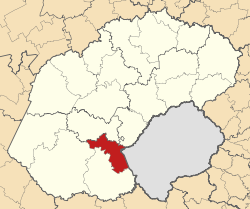
Country South Africa Province Free State District Xhariep District Seat Dewetsdorp Area - Total 3,423.9 km2 (1,322 sq mi) Population (2007)[1] - Total 25,442 - Density 7.4/km2 (19.2/sq mi) - Households 8,279 Racial makeup[2] (2007) - Black African 90.72% - White 6.19% - Coloured 2.52% - Indian or Asian 0.58% Time zone SAST (UTC+2) Municipal code FS171 Naledi Local Municipality is an administrative area in the Xhariep District of the Free State in South Africa. The name is a Sesotho word meaning "a star".[3]
References
- ^ "Community Survey, 2007: Basic Results Municipalities" (PDF). Statistics South Africa. http://www.statssa.gov.za/Publications/P03011/P030112007.pdf. Retrieved 2009-10-20.
- ^ "Community Survey 2007 interactive data". Statistics South Africa. http://www.statssa.gov.za/community_new/content.asp?link=interactivedata.asp. Retrieved 19 October 2009.
- ^ South African Languages - Place names
Province of Free State, South Africa Provincial Capital: Bloemfontein Metropolitan
MunicipalityDistrict
and Local
MunicipalitiesLetsemeng · Kopanong · Mohokare · NalediThabo MofutsanyanaCategories:- Local municipalities of Motheo

Wikimedia Foundation. 2010.