- List of United States National Lakeshores and Seashores
-
The United States has ten protected areas known as national seashores and four known as national lakeshores, which are operated by the National Park Service, an agency of the Department of the Interior. National seashores and lakeshores must be established by an act of the United States Congress. National seashores and lakeshores are coastal areas federally designated as being of natural and recreational significance as a preserved area. The first national seashore, Cape Hatteras, was established in 1953, and Indiana Dune National Lakeshore was established in 1966. The newest national lakeshore is seashore is Canaveral, established in 1975. All of the national lakeshores are on lakes Michigan and Superior, and nine of the ten national seashores are on the Atlantic Ocean, including two on the Gulf of Mexico.
National seashores are located in ten states and national lakeshores are in four other states. Florida, North Carolina, and Michigan each have two. The largest national seashore or lakeshore is Gulf Islands, at over 137,000 acres (550 km2); the smallest is Indiana Dunes, at 15,000 acres (61 km2). The total areas protected by national seashores and lakeshores are approximately 595,000 acres (2,410 km2) and 229,000 acres (930 km2), respectively.[1]
Contents
National Seashores
Name Photo Location Date Formed[1][2] Area[1] Description Assateague Island 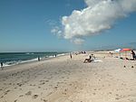
Maryland, Virginia
38°05′N 75°13′W / 38.08°N 75.21°WSeptember 21, 1965 39,726.75 acres (160.8 km2) As a barrier island, Assateague Island is continually shaped by wind and waves. It is known for its feral horses and is also home to deer, crabs, fox, and migrating snow geese. Main vegetation includes American beach grass, saltmarsh cordgrass and sea rocket.[3] Canaveral 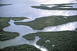
Florida
28°46′N 80°47′W / 28.77°N 80.78°WJanuary 3, 1975 57,661.69 acres (233.3 km2) Adjacent to the Kennedy Space Center, this barrier island has a variety of recreational activities including hiking, boating, and fishing. The Seminole Rest features an ancient Native American mound, and Eldora Statehouse shows historic life on the lagoon. Florida's longest undeloped Atlantic beach surrounds Mosquito Lagoon, which is home to dolphins, manatees, and sea turtles, along with a variety of sea grasses.[4] Cape Cod 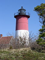
Massachusetts
41°57′N 70°00′W / 41.95°N 70.00°WAugust 7, 1961 43,608.48 acres (176.5 km2) Beyond its nearly 40 miles of beaches, this historic area has Marconi Station, the Three Sisters Lighthouses, and the former North Truro Air Force Station. Cranberry bogs, marshes, and hiking trails provide a look into the flora and fauna of Cape Cod.[5] Cape Hatteras 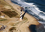
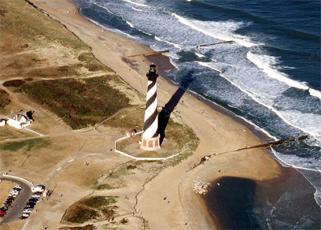
North Carolina
35°18′N 75°31′W / 35.30°N 75.51°WJanuary 12, 1953 30,350.65 acres (122.8 km2) Located in the Outer Banks, Cape Hatteras is known for its Bodie Island and Cape Hatteras Lighthouses. Popular recreation activities include windsurfing, birdwatching, fishing, shell collecting, and kayaking. Constantly changing from ocean activity, this barrier island provides refuge for the endangered piping plover, seabeach amaranth, and sea turtles.[6] Cape Lookout 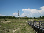
North Carolina
34°37′N 76°32′W / 34.61°N 76.54°WMarch 10, 1966 28,243.36 acres (114.3 km2) Cape Lookout National Seashore is made up of three islands of the Outer Banks. It is known for its wild horses and the Cape Lookout Lighthouse. Hiking, camping, fishing, and birdwatching are popular recreational activities. It is also home to two historic villages.[7] Cumberland Island 
Georgia
30°50′N 81°27′W / 30.83°N 81.45°WOctober 23, 1972 36,415.13 acres (147.4 km2) Cumberland Island is the site of the Plum Orchard estate, Thomas Carnegie's ruined Dungeness mansion, and an African Baptist church. The museum on the mainland preserves Timucua Indian history, Nathaniel Green and Eli Whitney's works, and War of 1812 battles.[8] Fire Island 
New York
40°42′N 72°59′W / 40.70°N 72.98°WSeptember 11, 1964 19,579.47 acres (79.2 km2) Fire Island, a barrier island south of Long Island, has the historic William Floyd House and Fire Island Lighthouse. The beaches and dunes are complemented by a sunken forest, wetlands, and seventeen communities.[9] Gulf Islands 
Florida, Mississippi
30°22′N 86°58′W / 30.36°N 86.97°WJanuary 8, 1971 137,990.97 acres (558.4 km2) Seven main islands have four historic forts built by the Spanish, British, and Americans that were used for defense in the Civil War. Apache Indians once lived here, including Geronimo. There are nature trails for wildlife viewing and long beaches for snorkeling, biking, and other activities.[10] Padre Island 
Texas
27°00′N 97°23′W / 27°N 97.38°WApril 6, 1968 130,434.27 acres (527.8 km2) Padre Island, the world's longest undeveloped barrier island, is a nesting ground for the Kemp's ridley sea turtle and a migratory site for Least Terns, Brown Pelicans, and Piping Plovers. Malaquite Beach provides a variety of recreational activities, and Novillo Line Camp has the remains of a cattle ranch. The military used part of the island as a bombing range during WWII.[11] Point Reyes 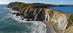
California
38°00′N 123°00′W / 38.00°N 123.00°WOctober 20, 1972 71,067.78 acres (287.6 km2) Historic locations on Point Reyes Peninsula include the Point Reyes Lighthouse and Lifeboat Station and a recreated Coast Miwok village. Gray whales can be seen as they migrate near the seashore, and tule elk and elephant seals populate the wilderness area.[12] National Lakeshores
Name Photo Location Date Formed[1][2] Area[1] Description Apostle Islands 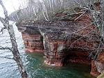
Wisconsin
46°58′N 90°40′W / 46.97°N 90.66°WSeptember 26, 1970 69,371.89 acres (280.7 km2) [13] Indiana Dunes 
Indiana
41°39′N 87°07′W / 41.65°N 87.12°WNovember 6, 1966 15,067.38 acres (61.0 km2) [14] Pictured Rocks 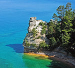
Michigan
46°34′N 86°19′W / 46.56°N 86.31°WOctober 15, 1966 73,235.83 acres (296.4 km2) [15] Sleeping Bear Dunes 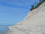
Michigan
44°55′N 86°01′W / 44.91°N 86.02°WOctober 21, 1970 71,198.48 acres (288.1 km2) [16] See also
- List of areas in the United States National Park System
- History of the National Park Service
- List of National Historic Landmarks of the United States
- List of National Monuments of the United States
References
- ^ a b c d e (PDF) The National Parks: Index 2009–2011. Washington, D.C.: National Park Service. ISBN 9780912627816. http://www.nps.gov/history/history/online_books/nps/index2009_11.pdf. Retrieved 4 February 2011.
- ^ a b "National Park System Areas Listed in Chronological Order of Date Authorized under DOI" (PDF). National Park Service. 27 June 2005. http://home.nps.gov/applications/budget2/documents/chronop.pdf. Retrieved 18 January 2010.
- ^ "Assateague Island National Seashore". National Park Service. http://www.nps.gov/asis/. Retrieved 22 January 2011.
- ^ "Canaveral National Seashore". National Park Service. http://www.nps.gov/cana/. Retrieved 22 January 2011.
- ^ "Cape Cod National Seashore". National Park Service. http://www.nps.gov/caco/. Retrieved 22 January 2011.
- ^ "Cape Hatteras National Seashore". National Park Service. http://www.nps.gov/caha/. Retrieved 22 January 2011.
- ^ "Cape Lookout National Seashore". National Park Service. http://www.nps.gov/calo/. Retrieved 22 January 2011.
- ^ "Cumberland Island National Seashore". National Park Service. http://www.nps.gov/cuis/. Retrieved 22 January 2011.
- ^ "Fire Island National Seashore". National Park Service. http://www.nps.gov/fiis/. Retrieved 22 January 2011.
- ^ "Gulf Islands National Seashore". National Park Service. http://www.nps.gov/guis/. Retrieved 22 January 2011.
- ^ "Padre Island National Seashore". National Park Service. http://www.nps.gov/pais/. Retrieved 22 January 2011.
- ^ "Point Reyes National Seashore". National Park Service. http://www.nps.gov/pore/. Retrieved 22 January 2011.
- ^ "Apostle Islands National Lakeshore". National Park Service. http://www.nps.gov/apis/. Retrieved 22 January 2011.
- ^ "Indiana Dunes National Lakeshore". National Park Service. http://www.nps.gov/indu/. Retrieved 22 January 2011.
- ^ "Pictured Rocks National Lakeshore". National Park Service. http://www.nps.gov/piro/. Retrieved 22 January 2011.
- ^ "Sleeping Bear Dunes National Lakeshore". National Park Service. http://www.nps.gov/slbe/. Retrieved 22 January 2011.
External links
- Official website of the National Park Service
- Find a Park by the NPS
United States National Lakeshores and National Seashores Assateague Island National Seashore • Canaveral National Seashore • Cape Cod National Seashore • Cape Hatteras National Seashore • Cape Lookout National Seashore • Cumberland Island National Seashore • Fire Island National Seashore • Gulf Islands National Seashore • Padre Island National Seashore • Point Reyes National Seashore
Great Lakes of North America Main lakes 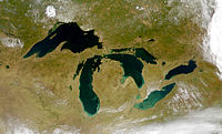
Secondary lakes Waterways Detroit River • Erie Canal • French River • Great Lakes Waterway • Niagara River • Nipigon River • St. Clair River • Saint Lawrence River • Saint Lawrence Seaway • St. Marys River • Soo Locks • Straits of Mackinac • Trent–Severn Waterway • Welland CanalLists of islands Historic geology Lakeshores Related topics Basin • Bays of the Great Lakes • Great Lakes region • Georgian Bay • Great Lake ships • Isle Royale • Lake effect • Manitoulin Island • Megalopolis • Quebec City – Windsor Corridor • Settlements • Shipwrecks • Tall shipsCategories:- United States National Park Service
- National Lakeshores of the United States
- National Seashores of the United States


Wikimedia Foundation. 2010.