- National Register of Historic Places listings in Ocean County, New Jersey
-
List of the National Register of Historic Places listings in Ocean County, New Jersey
Contents: Counties in New Jersey Atlantic - Bergen - Burlington - Camden - Cape May - Cumberland - Essex - Gloucester - Hudson - Hunterdon - Mercer - Middlesex - Monmouth - Morris - Ocean - Passaic - Salem - Somerset - Sussex - Union - Warren This is intended to be a complete list of properties and districts listed on the National Register of Historic Places in Ocean County, New Jersey. The locations of National Register properties and districts (at least for all showing latitude and longitude coordinates below) may be seen in a Google map by clicking on "Map of all coordinates".[1]
-
- This National Park Service list is complete through NPS recent listings posted November 10, 2011.[2]
[3] Site name[4] Image Date listed Location[1] City or Town Summary 1 Barnegat Light Public School June 7, 1976 501 Central Ave.
39°45′35″N 74°6′20″W / 39.75972°N 74.10556°WBarnegat Light 2 Barnegat Lighthouse 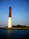
January 25, 1971 N end of Long Beach Island, off Broadway Ave.
39°45′51″N 74°6′23″W / 39.76417°N 74.10639°WBarnegat Light 3 Bay Head Historic District February 1, 2006 Roughly bounded by Point Pleasant Beach Borough line, Atlantic Ocean, Mantoloking Borough line and Point Pleasant
40°4′18″N 74°2′51″W / 40.07167°N 74.0475°WBay Head Borough 4 Beach Haven Historic District July 14, 1983 Roughly bounded by Bay and Atlantic Aves., Pearl and 3rd Sts.
39°33′32″N 74°14′31″W / 39.55889°N 74.24194°WBeach Haven 5 Capt. Amos Birdsall House May 13, 1982 234 Washington St.
39°57′8″N 74°11′30″W / 39.95222°N 74.19167°WToms River 6 A.A. Brant House May 13, 1982 9 Allen St.
39°57′4″N 74°11′43″W / 39.95111°N 74.19528°WToms River 7 Cassville Crossroads Historic District August 26, 1982 Jct. of CR 571 and 528
40°6′17″N 74°23′14″W / 40.10472°N 74.38722°WJackson Township 8 Cavarly Cottage September 22, 2006 100 Stafford Ave.
39°41′50″N 74°15′19″W / 39.69722°N 74.25528°WStafford Township 9 Converse Cottage July 14, 1983 504 Atlantic Ave.
39°33′31″N 74°14′25″W / 39.55861°N 74.24028°WBeach Haven 10 Mary Etta Cox House March 9, 2005 353 N. Main St.
39°45′13″N 74°13′26″W / 39.75361°N 74.22389°WBarnegat 11 Crawford House May 13, 1982 46 E. Water St.
39°57′3″N 74°11′46″W / 39.95083°N 74.19611°WToms River 12 Double Trouble Historic District 
February 23, 1978 S of Beachwood off Garden State Pkwy.
39°53′51″N 74°13′37″W / 39.8975°N 74.22694°WBayville 13 Falkinburg Farmstead August 12, 1993 28 Westcott Ave., Ocean Township
39°47′3″N 74°11′35″W / 39.78417°N 74.19306°WWaretown 14 Georgian Court 
December 20, 1978 Lakewood Ave.
40°5′52″N 74°13′37″W / 40.09778°N 74.22694°WLakewood 15 Capt. George W. Giberson House August 12, 1982 54 E. Water St.
39°57′3″N 74°11′46″W / 39.95083°N 74.19611°WToms River 16 Hangar No. 1, Lakehurst Naval Air Station 
May 23, 1968 N of Lakehurst on CR 547
40°1′44″N 74°18′59″W / 40.02889°N 74.31639°WManchester Township 17 Horner House May 13, 1982 44 E. Water St.
39°57′4″N 74°11′47″W / 39.95111°N 74.19639°WToms River 18 Island Heights Historic District July 8, 1982 Roughly bounded by Toms River, Summit and River Aves.
39°56′26″N 74°8′43″W / 39.94056°N 74.14528°WIsland Heights 19 Little Egg Harbor Friends Meeting House December 9, 2002 21 E. Main St.
39°36′12″N 74°20′29″W / 39.60333°N 74.34139°WTuckerton 20 Manahawkin Baptist Church April 3, 1973 N. Main St. (US 9) and Lehigh Ave.
39°41′55″N 74°15′29″W / 39.69861°N 74.25806°WManahawkin 21 Manitou Park School House March 15, 2005 167 Third Ave.
39°56′48″N 74°13′3″W / 39.94667°N 74.2175°WBerkeley 22 Ocean County Courthouse August 16, 1983 Washington St.
39°57′10″N 74°11′41″W / 39.95278°N 74.19472°WToms River 23 Ocean County Jail August 16, 1983 Sheriff St.
39°57′12″N 74°11′41″W / 39.95333°N 74.19472°WToms River 24 Orient Baptist Church August 10, 1977 NJ 88
40°4′11″N 74°7′40″W / 40.06972°N 74.12778°WLaurelton 25 Stewart House May 13, 1982 57 E. Water St.
39°57′3″N 74°11′46″W / 39.95083°N 74.19611°WToms River 26 Stoutenburgh-Minturn House May 13, 1982 86 E. Water St.
39°57′2″N 74°11′36″W / 39.95056°N 74.19333°WToms River 27 Strand Theatre April 22, 1982 400 Clifton Ave.
40°5′39″N 74°12′57″W / 40.09417°N 74.21583°WLakewood 28 Torrey-Larrabee Store February 21, 1997 11 Union Ave.
40°6′9″N 74°18′34″W / 40.1025°N 74.30944°WLakehurst 29 U.S. Life Saving Station Station No. 14 January 30, 1978 S of Seaside Park on Island Beach State Park
39°56′1″N 74°4′17″W / 39.93361°N 74.07139°WSeaside Park 30 Whitesbog Historic District October 27, 1988 N of SR 70 and S of Fort Dix
39°57′36″N 74°29′23″W / 39.96°N 74.48972°WWhiting 31 Dr. Edward H. Williams House July 14, 1983 506 S. Atlantic Ave.
39°33′31″N 74°14′25″W / 39.55861°N 74.24028°WBeach Haven References
- ^ a b The latitude and longitude information provided in this table was derived originally from the National Register Information System, which has been found to be fairly accurate for about 99% of listings. For about 1% of NRIS original coordinates, experience has shown that one or both coordinates are typos or otherwise extremely far off; some corrections may have been made. A more subtle problem causes many locations to be off by up to 150 yards, depending on location in the country: most NRIS coordinates were derived from tracing out latitude and longitudes off of USGS topographical quadrant maps created under the North American Datum of 1927, which differs from the current, highly accurate WGS84 GPS system used by Google maps. Chicago is about right, but NRIS longitudes in Washington are higher by about 4.5 seconds, and are lower by about 2.0 seconds in Maine. Latitudes differ by about 1.0 second in Florida. Some locations in this table may have been corrected to current GPS standards.
- ^ "National Register of Historic Places: Weekly List Actions". National Park Service, United States Department of the Interior. Retrieved on November 10, 2011.
- ^ Numbers represent an ordering by significant words. Various colorings, defined here, differentiate National Historic Landmark sites, a [[National Historic Site (United States)|]], and several National Register of Historic Places Districts from other NRHP buildings, structures, sites or objects.
- ^ "National Register Information System". National Register of Historic Places. National Park Service. 2008-04-24. http://nrhp.focus.nps.gov/natreg/docs/All_Data.html.
U.S. National Register of Historic Places Topics Lists by states Alabama • Alaska • Arizona • Arkansas • California • Colorado • Connecticut • Delaware • Florida • Georgia • Hawaii • Idaho • Illinois • Indiana • Iowa • Kansas • Kentucky • Louisiana • Maine • Maryland • Massachusetts • Michigan • Minnesota • Mississippi • Missouri • Montana • Nebraska • Nevada • New Hampshire • New Jersey • New Mexico • New York • North Carolina • North Dakota • Ohio • Oklahoma • Oregon • Pennsylvania • Rhode Island • South Carolina • South Dakota • Tennessee • Texas • Utah • Vermont • Virginia • Washington • West Virginia • Wisconsin • WyomingLists by territories Lists by associated states Other  State of New Jersey
Topics Regions - Atlantic Coastal Plain
- Central Jersey
- Delaware River Region
- Delaware Valley
- Gateway Region
- Gold Coast
- Highlands
- Jersey Shore
- Meadowlands
- New York metro area
- North Hudson
- North Jersey
- Pascack Valley
- Piedmont
- Pine Barrens
- Raritan Bayshore
- Ridge-and-Valley Appalachians
- Southern Shore Region
- Skylands Region
- South Jersey
- Tri‑State Region
- West Hudson
Counties Major cities Categories:- National Register of Historic Places in New Jersey
- Ocean County, New Jersey
-


Wikimedia Foundation. 2010.