- National Register of Historic Places listings in Pitkin County, Colorado
-
 Location of Pitkin County in Colorado
This is a list of the National Register of Historic Places listings in Pitkin County, Colorado.
This is intended to be a complete list of the properties and districts on the National Register of Historic Places in Pitkin County, Colorado, United States. The locations of National Register properties and districts for which the latitude and longitude coordinates are included below, may be seen in a Google map.[1]
There are 31 properties and districts listed on the National Register in the county.
-
- This National Park Service list is complete through NPS recent listings posted November 10, 2011.[2]
Contents: Counties in Colorado (links in italic lead to a new page) Adams - Alamosa - Arapahoe - Archuleta - Baca - Bent - Boulder - Broomfield - Chaffee - Cheyenne - Clear Creek - Conejos - Costilla - Crowley - Custer - Delta - Denver - Dolores - Douglas - Eagle - El Paso - Elbert - Fremont - Garfield - Gilpin - Grand - Gunnison - Hinsdale - Huerfano - Jackson - Jefferson - Kiowa - Kit Carson - La Plata - Lake - Larimer - Las Animas - Lincoln - Logan - Mesa - Mineral - Moffat - Montezuma - Montrose - Morgan - Otero - Ouray - Park - Phillips - Pitkin - Prowers - Pueblo - Rio Blanco - Rio Grande - Routt - Saguache - San Juan - San Miguel - Sedgwick - Summit - Teller - Washington - Weld - Yuma Current listings
[3] Landmark name Image Date listed Location City or town Summary 1 Armory Hall, Fraternal Hall 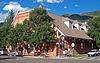
June 5, 1975 130 S. Galena St.
39°11′23″N 106°49′03″W / 39.189722°N 106.8175°WAspen 1892 armory building now used as city hall 2 Ashcroft, Colorado 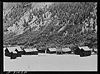
May 12, 1975 12 miles south of Aspen in the White River National Forest
39°03′16″N 106°47′52″W / 39.054444°N 106.797778°WAspen 3 Aspen Community Church 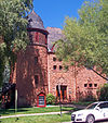
May 12, 1975 200 N. Aspen St.
39°11′32″N 106°49′13″W / 39.192222°N 106.820278°WAspen Original Presbyterian congregation swapped well-preserved 1891 church with Methodists in 1934 4 Boat Tow 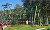
June 22, 1990 700 S. Aspen St.
39°11′14″N 106°48′38″W / 39.187222°N 106.810556°WAspen First ski lift built for Aspen ski area used old mining facilities and boats. Later replaced by Ski Lift No. 1, at the time of construction the world's longest ski lift. 5 Bowles–Cooley House 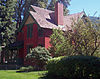
March 6, 1987 201 W. Francis St.
39°11′38″N 106°49′23″W / 39.193889°N 106.823056°WAspen Brick Queen Anne Style house built in 1889 for local lumber dealer 6 Matthew Callahan Log Cabin 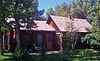
March 6, 1987 205 S. 3rd St.
39°11′28″N 106°49′34″W / 39.191111°N 106.826111°WAspen One of the few pre-mining structures left in Aspen; dates to the early 1880s 7 Collins Block–Aspen Lumber and Supply 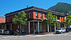
March 6, 1987 204 S. Mill St.
39°11′23″N 106°49′07″W / 39.189722°N 106.818611°WAspen Early 1890s commercial building with unusual classical decorative touches including colonnade 8 Dixon–Markle House 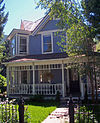
March 6, 1987 135 E. Cooper Ave.
39°11′19″N 106°49′19″W / 39.188611°N 106.821944°WAspen 1888 frame Queen Anne miner's house with unusual projecting northeast corner bay 9 D.E. Frantz House 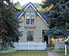
March 6, 1987 333 W. Bleeker St.
39°11′34″N 106°49′31″W / 39.192778°N 106.825278°WAspen 10 Samuel I. Hallett House 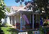
March 6, 1987 432 W. Francis St.
39°11′41″N 106°50′15″W / 39.194722°N 106.8375°WAspen 1885 log cabin later expanded by local mine owner 11 Holden Mining and Smelting Co. 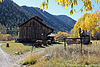
June 22, 1990 1000 block of W. State Highway 82
39°11′34″N 106°50′05″W / 39.192778°N 106.834722°WAspen 12 Hotel Jerome 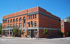
March 20, 1986 330 E. Main St.
39°11′28″N 106°49′08″W / 39.191111°N 106.818889°WAspen Hotel built by Jerome Wheeler in 1889, an Aspen landmark, was one of the first buildings west of the Mississippi to have full electric lighting. Ballroom is the only one in Aspen above ground. 13 Hyman–Brand Building 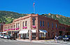
January 18, 1985 203 S. Galena St.
39°11′22″N 106°49′05″W / 39.189444°N 106.818056°WAspen 1891 sandstone commercial building 14 Thomas Hynes House 
March 6, 1987 303 E. Main St.
39°11′27″N 106°49′10″W / 39.190833°N 106.819444°WAspen Surviving 1887 miner's cabin now a Japanese restaurant 15 Independence and Independence Mill Site 
April 11, 1973 On State Highway 82 in White River National Forest
39°06′26″N 106°36′28″W / 39.107222°N 106.607778°WWhite River National Forest Remains of 1880s mining settlement below Independence Pass abandoned after 10 years 16 La Fave Block 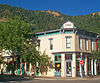
March 6, 1987 405 S. Hunter St.
39°11′16″N 106°49′03″W / 39.187778°N 106.8175°WAspen Ornate 1888 commercial building; now one of Aspen's most valuable properties 17 Maroon Creek Bridge 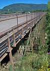
February 4, 1985 State Highway 82
39°11′43″N 106°50′02″W / 39.195278°N 106.833889°WAspen 1888 Colorado Midland Railroad Bridge made Aspen accessible by rail. Closed in 1929 after railroad's bankruptcy, it was widened and opened for automobile traffic in 1929. It continued to be used in that capacity until a replacement bridge was built next to it in 2008. 18 New Brick-The Brick Saloon 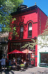
March 6, 1987 420 E. Cooper Ave.
39°11′19″N 106°49′07″W / 39.188611°N 106.818611°WAspen 1892 saloon, long known as "The Red Onion" is Aspen's oldest operating restaurant 19 Newberry House 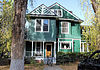
March 6, 1987 206 Lake Ave.
39°11′42″N 106°49′20″W / 39.195°N 106.822222°WAspen 20 Osgood Castle 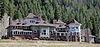
June 28, 1971 About 1 mile south of Redstone on State Highway 133 Redstone 21 Osgood Gamekeeper's Lodge 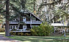
July 19, 1989 18679 State Highway 133
39°10′12″N 107°14′41″W / 39.17°N 107.244722°WRedstone 22 Osgood-Kuhnhausen House 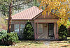
August 18, 1983 0642 Redstone Boulevard
39°11′13″N 107°14′03″W / 39.186944°N 107.234167°WRedstone 23 Pitkin County Courthouse 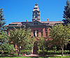
May 12, 1975 506 E. Main St.
39°11′26″N 106°49′01″W / 39.190556°N 106.816944°WAspen Statue of Lady Justice in front of 1890 courthouse is unusually not wearing a blindfold 24 Redstone Coke Oven Historic District 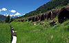
February 7, 1990 State Highway 133 and Chair Mountain Stables Rd.
39°10′55″N 107°14′26″W / 39.181944°N 107.240556°WRedstone Coke ovens built by Colorado Fuel and Iron in 1899 are among the few of this type remaining in the West. 25 Redstone Historic District 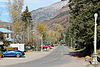
July 19, 1989 Roughly along the Crystal River from Hawk Creek to 226 Redstone Boulevard
39°10′16″N 107°14′16″W / 39.171111°N 107.237778°WRedstone 26 Redstone Inn 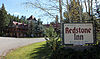
March 27, 1980 0082 Redstone Boulevard
39°10′49″N 107°14′21″W / 39.180278°N 107.239167°WRedstone 27 Riede's City Bakery 
March 6, 1987 413 E. Hyman Ave.
39°11′20″N 106°49′08″W / 39.188889°N 106.818889°WAspen One of only two wood frame commercial buildings left in city from original boom years 28 Sheely Bridge 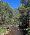
February 4, 1985 Mill Street Park
39°11′27″N 106°48′46″W / 39.190833°N 106.812778°WAspen 1911 steel truss bridge designed by William Sheely was moved to Aspen from Carbondale. One of the first trusses in Colorado to use rivets. 29 Shilling-Lamb House 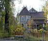
March 6, 1987 525 N. 2nd St.
39°11′43″N 106°49′26″W / 39.195278°N 106.823889°WAspen 30 Smith-Elisha House 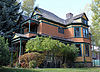
January 19, 1989 320 W. Main St.
39°11′32″N 106°49′30″W / 39.192222°N 106.825°WAspen 31 Smuggler Mine May 18, 1987 Smuggler Mountain
39°11′35″N 106°48′23″W / 39.193056°N 106.806389°WAspen 32 Ute Cemetery 
April 1, 2002 Ute Ave.
39°10′57″N 106°48′43″W / 39.1825°N 106.811944°WAspen Established in 1880 to bury an early pioneer, it became the final resting place of many of Aspen's working-class residents through the Depression. 33 Davis Waite House 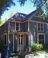
March 6, 1987 234 W. Francis St.
39°11′37″N 106°49′25″W / 39.193611°N 106.823611°WAspen 1888 Victorian home of Davis H. Waite, one-term governor of Colorado and Aspen Daily Times co-founding publisher. 34 Henry Webber House-Pioneer Park 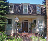
March 6, 1987 442 W. Bleeker St.
39°11′36″N 106°49′34″W / 39.193333°N 106.826111°WAspen 1885 home of local shoe merchant and mining investor Henry Webber is only intact Second Empire house in Aspen 35 Wheeler Opera House 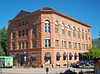
August 21, 1972 330 E. Hyman Ave.
39°11′22″N 106°49′00″W / 39.189444°N 106.816667°WAspen 1889 sandstone building was city's first listed property. Walk-in safe from original bank on first floor still present. Interior extensively renovated in mid-20th century from design by Herbert Bayer. 36 Wheeler–Stallard House 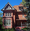
May 30, 1975 620 W. Bleeker St.
39°11′37″N 106°49′43″W / 39.193611°N 106.828611°WAspen Queen Anne house built in 1888 by early Aspen entrepreneur Jerome Wheeler. One of the best examples of that style in the city; later owned by Walter Paepcke. Since 1969 home to the Aspen Historical Society. See also
- List of National Historic Landmarks in Colorado
- National Register of Historic Places listings in Colorado
References
- ^ The latitude and longitude information provided in this table was derived originally from the National Register Information System, which has been found to be fairly accurate for about 99% of listings. For about 1% of NRIS original coordinates, experience has shown that one or both coordinates are typos or otherwise extremely far off; some corrections may have been made. A more subtle problem causes many locations to be off by up to 150 yards, depending on location in the country: most NRIS coordinates were derived from tracing out latitude and longitudes off of USGS topographical quadrant maps created under the North American Datum of 1927, which differs from the current, highly accurate WGS84 GPS system used by Google maps. Chicago is about right, but NRIS longitudes in Washington are higher by about 4.5 seconds, and are lower by about 2.0 seconds in Maine. Latitudes differ by about 1.0 second in Florida. Some locations in this table may have been corrected to current GPS standards.
- ^ "National Register of Historic Places: Weekly List Actions". National Park Service, United States Department of the Interior. Retrieved on November 10, 2011.
- ^ Numbers represent an ordering by significant words. Various colorings, defined here, differentiate National Historic Landmark sites and National Register of Historic Places Districts from other NRHP buildings, structures, sites or objects.
External links
- Pitkin County National and State Registers, Colorado Historical Society Office of Archaeology and Historic Preservation
U.S. National Register of Historic Places Topics Lists by states Alabama • Alaska • Arizona • Arkansas • California • Colorado • Connecticut • Delaware • Florida • Georgia • Hawaii • Idaho • Illinois • Indiana • Iowa • Kansas • Kentucky • Louisiana • Maine • Maryland • Massachusetts • Michigan • Minnesota • Mississippi • Missouri • Montana • Nebraska • Nevada • New Hampshire • New Jersey • New Mexico • New York • North Carolina • North Dakota • Ohio • Oklahoma • Oregon • Pennsylvania • Rhode Island • South Carolina • South Dakota • Tennessee • Texas • Utah • Vermont • Virginia • Washington • West Virginia • Wisconsin • WyomingLists by territories Lists by associated states Other Municipalities and communities of Pitkin County, Colorado City 
Towns CDPs Unincorporated
communitiesGhost towns Footnotes ‡This populated place also has portions in an adjacent county or counties
Categories:- National Register of Historic Places in Colorado by county
- Pitkin County, Colorado
- Buildings and structures in Pitkin County, Colorado
-


Wikimedia Foundation. 2010.