- National Register of Historic Places listings in Abbeville County, South Carolina
-
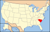
 Location of Abbeville County in South Carolina
This is a list of the National Register of Historic Places listings in Abbeville County, South Carolina.
This is intended to be a complete list of the properties and districts on the National Register of Historic Places in Abbeville County, South Carolina, United States. The locations of National Register properties and districts for which the latitude and longitude coordinates are included below, may be seen in a Google map.[1]
There are 13 properties and districts listed on the National Register in the county, including 1 National Historic Landmark.
-
- This National Park Service list is complete through NPS recent listings posted November 10, 2011.[2]
Current listings
[3] Landmark name [4] Image Date listed Location City or town Summary 1 Abbeville County Courthouse 
October 30, 1981 Court Square
34°10′41″N 82°22′43″W / 34.178056°N 82.378611°WAbbeville 2 Abbeville Historic District 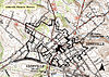
September 14, 1972 Roughly bounded by the former Seaboard Coast Line tracks, South Carolina Highway 72, Rickey, Haight, Hemphill, and Haigler Sts.; also roughly east of Magazine St., south of Whitehall St., northwest along Long Branch St., west of Lemon St., and north along Washington St.; also roughly west along N. Main St. from Haigler to Livingston Sts., north along Greenville St., and northeast on Marshall Ct.
34°10′52″N 82°22′43″W / 34.181111°N 82.378611°WAbbeville Second and third sets of boundaries represent a boundary decrease of September 14, 1972 and a boundary increase of May 7, 1984 respectively 3 Abbeville Opera House 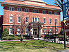
July 1, 1970 Court Square
34°10′40″N 82°22′42″W / 34.177778°N 82.378333°WAbbeville 4 Armistead Burt House 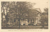
April 3, 1970 306 N. Main St.
34°10′52″N 82°22′59″W / 34.181111°N 82.383056°WAbbeville 5 Patrick Calhoun Family Cemetery August 28, 1975 9.5 miles southwest of Abbeville on SC 823
34°03′43″N 82°26′45″W / 34.061944°N 82.445833°WAbbeville 6 Cedar Springs Historic District 
March 25, 1982 South Carolina Highways 33, 47, and 112
34°04′50″N 82°18′08″W / 34.080556°N 82.302222°WAbbeville 7 Donalds Grange No. 497 January 9, 1995 South Carolina Highway 184
34°22′06″N 82°21′07″W / 34.368333°N 82.351944°WDonalds 8 Erskine College-Due West Historic District 
March 19, 1982 Main, Church, College, Bonner, Hayne, Washington, Cleveland, Depot, and Abbeville Sts.
34°19′45″N 82°23′26″W / 34.329167°N 82.390556°WDue West 9 Harbison College President's Home January 13, 1983 North of Abbeville on South Carolina Highway 20
34°11′45″N 82°23′05″W / 34.195833°N 82.384722°WAbbeville 10 Lindsay Cemetery May 27, 2009 Lindsay Cemetery Rd. Due West 11 Trinity Episcopal Church and Cemetery May 6, 1971 Church St.
34°10′35″N 82°22′49″W / 34.176389°N 82.380278°WAbbeville 12 Upper Long Cane Cemetery December 17, 2010 Greenville St. (South Carolina Highway 20 North) at junction with Beltline Rd. (SC Sec Rd 1-35)
34°12′13″N 82°23′24″W / 34.203611°N 82.39°WAbbeville vicinity 13 Young Place October 9, 1974 South Carolina Highway 185
34°19′59″N 82°23′56″W / 34.333056°N 82.398889°WDue West See also
- List of National Historic Landmarks in South Carolina
- National Register of Historic Places listings in South Carolina
References
- ^ The latitude and longitude information provided in this table was derived originally from the National Register Information System, which has been found to be fairly accurate for about 99% of listings. For about 1% of NRIS original coordinates, experience has shown that one or both coordinates are typos or otherwise extremely far off; some corrections may have been made. A more subtle problem causes many locations to be off by up to 150 yards, depending on location in the country: most NRIS coordinates were derived from tracing out latitude and longitudes off of USGS topographical quadrant maps created under North American Datum of 1927, which differs from the current, highly accurate GPS system used by Google maps. Chicago is about right, but NRIS longitudes in Washington are higher by about 4.5 seconds, and are lower by about 2.0 seconds in Maine. Latitudes differ by about 1.0 second in Florida. Some locations in this table may have been corrected to current GPS standards.
- ^ "National Register of Historic Places: Weekly List Actions". National Park Service, United States Department of the Interior. Retrieved on November 10, 2011.
- ^ Numbers represent an ordering by significant words. Various colorings, defined here, differentiate National Historic Landmark sites and National Register of Historic Places Districts from other NRHP buildings, structures, sites or objects.
- ^ "National Register Information System". National Register of Historic Places. National Park Service. . http://nrhp.focus.nps.gov/natreg/docs/All_Data.html.
U.S. National Register of Historic Places in South Carolina Lists by county Abbeville • Aiken • Allendale • Anderson • Bamberg • Barnwell • Beaufort • Berkeley • Calhoun • Charleston • Cherokee • Chester • Chesterfield • Clarendon • Colleton • Darlington • Dillon • Dorchester • Edgefield • Fairfield • Florence • Georgetown • Greenville • Greenwood • Hampton • Horry • Jasper • Kershaw • Lancaster • Laurens • Lee • Lexington • Marion • Marlboro • McCormick • Newberry • Oconee • Orangeburg • Pickens • Richland • Saluda • Spartanburg • Sumter • Union • Williamsburg • York
Lists by city Other lists Keeper of the Register • History of the National Register of Historic Places • Property types • Historic district • Contributing property Municipalities and communities of Abbeville County, South Carolina County seat: Abbeville City 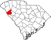
Towns Calhoun Falls | Donalds | Due West | Honea Path‡ | Lowndesville | Ware Shoals‡
CDPs Footnotes ‡This populated place also has portions in an adjacent county or counties
Categories:- Abbeville County, South Carolina
- National Register of Historic Places in South Carolina by county
-


Wikimedia Foundation. 2010.