- National Register of Historic Places listings in Aitkin County, Minnesota
-
 Location of Aitkin County in Minnesota
This is a list of the National Register of Historic Places listings in Aitkin County, Minnesota. It is intended to be a complete list of the properties and districts on the National Register of Historic Places in Aitkin County, Minnesota, United States. The locations of National Register properties and districts for which the latitude and longitude coordinates are included below, may be seen in a Google map.[1]
Historic resources in Aitkin County were identified in a "Multiple Resources Area" study, leading to several properties being listed on the NRHP.[2]
There are 10 properties and districts listed on the National Register in the county.
-
- This National Park Service list is complete through NPS recent listings posted November 10, 2011.[3]
Listings county-wide
[4] Landmark name [5] Image Date listed Location City or town Summary 1 Aitkin Carnegie Library 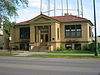
April 16, 1982 121 2nd St., NW.
46°32′00″N 93°42′33″W / 46.533333°N 93.709167°WAitkin Classical Revival Carnegie library 2 Aitkin County Courthouse and Jail 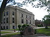
April 16, 1982 209 and 217 2nd St., NW.
46°31′59″N 93°42′37″W / 46.533056°N 93.710278°WAitkin Courthouse with Beaux-Arts and Moderne design elements 3 Arthyde Stone House April 16, 1982 County Road 27
46°21′17″N 93°05′22″W / 46.354722°N 93.089444°WMcGrath 4 Bethlehem Lutheran Church April 16, 1982 Off County Highway 12
46°28′34″N 93°36′59″W / 46.476111°N 93.616389°WAitkin 5 Patrick Casey House 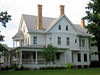
April 16, 1982 4th St., SE. and 2nd Ave.
46°31′36″N 93°42′13″W / 46.526667°N 93.703611°WAitkin 6 Malmo Mounds and Village Site April 3, 1975 Address Restricted McGrath 7 National Woodenware Company Superintendent's Residence April 16, 1982 SW. Elm St. and Ione Ave.
46°59′35″N 93°35′39″W / 46.993056°N 93.594167°WHill City 8 Northern Pacific Depot 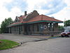
April 16, 1982 20 Pacific St., SW.
46°31′54″N 93°42′27″W / 46.531667°N 93.7075°WAitkin 9 Potter/Casey Company Building 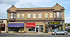
April 16, 1982 E. Minnesota Ave. between 1st and 2nd Sts., NW.
46°31′58″N 93°42′22″W / 46.532778°N 93.706111°WAitkin 10 Savanna Portage 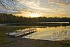
April 23, 1973 Off County Highway 5 in Savanna Portage State Park
46°50′32″N 93°07′27″W / 46.842222°N 93.124167°WMcGregor See also
- List of National Historic Landmarks in Minnesota
- National Register of Historic Places listings in Minnesota
References
- ^ The latitude and longitude information provided in this table was derived originally from the National Register Information System, which has been found to be fairly accurate for about 99% of listings. For about 1% of NRIS original coordinates, experience has shown that one or both coordinates are typos or otherwise extremely far off; some corrections may have been made. A more subtle problem causes many locations to be off by up to 150 yards, depending on location in the country: most NRIS coordinates were derived from tracing out latitude and longitudes off of USGS topographical quadrant maps created under North American Datum of 1927, which differs from the current, highly accurate GPS system used by Google maps. Chicago is about right, but NRIS longitudes in Washington are higher by about 4.5 seconds, and are lower by about 2.0 seconds in Maine. Latitudes differ by about 1.0 second in Florida. Some locations in this table may have been corrected to current GPS standards.
- ^ Haidet, Mark E. (June, 1981). "National Register of Historic Places Inventory - Nomination Form: Aitkin County Multiple Resource Area / Historic Resources of Aitkin County (Partial Inventory)". http://pdfhost.focus.nps.gov/docs/NRHP/Text/64000339.pdf. Retrieved 2009-01-19.
- ^ "National Register of Historic Places: Weekly List Actions". National Park Service, United States Department of the Interior. Retrieved on November 10, 2011.
- ^ Numbers represent an ordering by significant words. Various colorings, defined here, differentiate National Historic Landmark sites and National Register of Historic Places Districts from other NRHP buildings, structures, sites or objects.
- ^ "National Register Information System". National Register of Historic Places. National Park Service. . http://nrhp.focus.nps.gov/natreg/docs/All_Data.html.
U.S. National Register of Historic Places Topics Lists by states Alabama • Alaska • Arizona • Arkansas • California • Colorado • Connecticut • Delaware • Florida • Georgia • Hawaii • Idaho • Illinois • Indiana • Iowa • Kansas • Kentucky • Louisiana • Maine • Maryland • Massachusetts • Michigan • Minnesota • Mississippi • Missouri • Montana • Nebraska • Nevada • New Hampshire • New Jersey • New Mexico • New York • North Carolina • North Dakota • Ohio • Oklahoma • Oregon • Pennsylvania • Rhode Island • South Carolina • South Dakota • Tennessee • Texas • Utah • Vermont • Virginia • Washington • West Virginia • Wisconsin • WyomingLists by territories Lists by associated states Other  Category:National Register of Historic Places •
  Portal:National Register of Historic Places
Municipalities and communities of Aitkin County, Minnesota County seat: Aitkin Cities 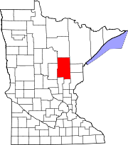
Townships Aitkin | Ball Bluff | Balsam | Beaver | Clark | Cornish | Farm Island | Fleming | Glen | Haugen | Hazelton | Hill Lake | Idun | Jevne | Kimberly | Lakeside | Lee | Libby | Logan | Macville | Malmo | McGregor | Millward | Morrison | Nordland | Pliny | Rice River | Salo | Seavey | Shamrock | Spalding | Spencer | Turner | Verdon | Wagner | Waukenabo | Wealthwood | White Pine | Williams | Workman
Unorganized
territoriesUnincorporated
communitiesGiese | Glen | Jacobson | Malmo | Sandy Lake | Swatara | Waukenabo
Indian
reservationsFootnotes ‡This populated place also has portions in an adjacent county or counties
Categories:- National Register of Historic Places in Minnesota by county
- Aitkin County, Minnesota
- Buildings and structures in Aitkin County, Minnesota
-


Wikimedia Foundation. 2010.