National Register of Historic Places listings in Banks County, Georgia
- National Register of Historic Places listings in Banks County, Georgia
-
This is a list of properties and districts in Banks County, Georgia that are listed on the National Register of Historic Places (NRHP).
-
- This National Park Service list is complete through NPS recent listings posted November 10, 2011.[1]
Current listings
| [2] |
Landmark name |
Image |
Date listed |
Location |
City or town |
Summary |
| 1 |
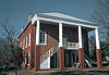
Banks County Courthouse |
|
01980-09-18September 18, 1980 |
Off U.S. 441
34°20′05″N 83°29′56″W / 34.334722°N 83.498889°W / 34.334722; -83.498889 (Banks County Courthouse) |
Homer |
|
| 2 |
Banks County Jail |
|
01982-07-26July 26, 1982 |
Silver Shoals Rd.
34°20′06″N 83°29′20″W / 34.335°N 83.488889°W / 34.335; -83.488889 (Banks County Jail) |
Homer |
|
| 3 |
William Chambers House |
|
01996-11-07November 7, 1996 |
GA 51, approximately 1 mi. W of jct. with GA 59
34°22′15″N 83°25′13″W / 34.370833°N 83.420278°W / 34.370833; -83.420278 (William Chambers House) |
Carnesville |
|
| 4 |
Fort Hollingsworth-White House |
|
01998-08-06August 6, 1998 |
Wynn Lake Rd., 2 mi. SE of Hollingsworth
34°25′35″N 83°32′02″W / 34.426389°N 83.533889°W / 34.426389; -83.533889 (Fort Hollingsworth-White House) |
Hollingsworth |
|
| 5 |
Gillsville Historic District |
|
01985-08-30August 30, 1985 |
GA 52
34°18′38″N 83°38′20″W / 34.310556°N 83.638889°W / 34.310556; -83.638889 (Gillsville Historic District) |
Gillsville |
|
| 6 |
Hebron Church, Cemetery, and Academy |
|
01985-09-12September 12, 1985 |
CR 3
34°17′12″N 83°21′53″W / 34.286667°N 83.364722°W / 34.286667; -83.364722 (Hebron Church, Cemetery, and Academy) |
Commerce |
|
| 7 |
Homer Historic District |
|
01985-12-03December 3, 1985 |
Along Main St. and Silver Shoals Rd.
34°19′59″N 83°29′52″W / 34.333056°N 83.497778°W / 34.333056; -83.497778 (Homer Historic District) |
Homer |
|
| 8 |
Kesler Covered Bridge |
|
01975-06-18June 18, 1975 |
10 mi. N of Homer on County Line Rd. over Middle Fork Broad River
34°25′27″N 83°23′16″W / 34.424167°N 83.387778°W / 34.424167; -83.387778 (Kesler Covered Bridge) |
Homer |
|
| 9 |
Maysville Historic District |
|
01985-09-12September 12, 1985 |
Along E. Main, W. Main and Homer Sts.
34°15′17″N 83°33′48″W / 34.254722°N 83.563333°W / 34.254722; -83.563333 (Maysville Historic District) |
Maysville |
|
| 10 |
Mount Pleasant Historic District |
|
01996-11-07November 7, 1996 |
Jct. of GA 51 and GA 184
|
Carnesville |
|
| 11 |
Nails Creek Historic District |
|
01996-11-07November 7, 1996 |
Jct. of GA 51 and GA 59
34°22′00″N 83°24′02″W / 34.366667°N 83.400556°W / 34.366667; -83.400556 (Nails Creek Historic District) |
Carnesville |
|
| 12 |
New Salem Covered Bridge |
|
01975-06-10June 10, 1975 |
6 mi. N of Commerce on SR S992 over Grove Creek
34°15′30″N 83°25′20″W / 34.258333°N 83.422222°W / 34.258333; -83.422222 (New Salem Covered Bridge) |
Commerce |
|
| 13 |
Turk Family Farm |
|
02003-01-08January 8, 2003 |
534 Carson Segars Rd.
34°17′37″N 83°32′43″W / 34.293611°N 83.545278°W / 34.293611; -83.545278 (Turk Family Farm) |
Maysville |
|
References
Categories:
- National Register of Historic Places in Georgia (U.S. state)
- Buildings and structures in Banks County, Georgia
Wikimedia Foundation.
2010.
Look at other dictionaries:
National Register of Historic Places listings in Fulton County, Georgia — This is a list of properties and districts in Fulton County, Georgia that are listed on the National Register of Historic Places (NRHP). It covers most of the NRHP properties in Atlanta, Georgia; other Atlanta listings are covered in National… … Wikipedia
National Register of Historic Places listings in Franklin County, Georgia — This is a list of properties and districts in Franklin County, Georgia that are listed on the National Register of Historic Places (NRHP). Map of all coordinates from Google Map of all coordinates from Bing … Wikipedia
National Register of Historic Places listings in Coweta County, Georgia — This is a list of properties and districts in Coweta County, Georgia that are listed on the National Register of Historic Places (NRHP). Map of all coordinates from Google Map of all coordinates from Bing … Wikipedia
National Register of Historic Places listings in Muscogee County, Georgia — This is a list of properties and districts in Muscogee County, Georgia that are listed on the National Register of Historic Places (NRHP). Map of all coordinates from Google Map of all coordinates from Bing … Wikipedia
National Register of Historic Places listings in Elbert County, Georgia — This is a list of properties and districts in Elbert County, Georgia that are listed on the National Register of Historic Places (NRHP). Map of all coordinates from Google Map of all coordinates from Bing … Wikipedia
National Register of Historic Places listings in Bartow County, Georgia — This is a list of properties and districts in Bartow County, Georgia that are listed on the National Register of Historic Places (NRHP). Map of all coordinates from Google Map of all coordinates from Bing … Wikipedia
National Register of Historic Places listings in Bibb County, Georgia — This is a list of properties and districts in Bibb County, Georgia that are listed on the National Register of Historic Places (NRHP). Map of all coordinates from Google Map of all coordinates from Bing … Wikipedia
National Register of Historic Places listings in Bulloch County, Georgia — This is a list of properties and districts in Bulloch County, Georgia that are listed on the National Register of Historic Places (NRHP). Map of all coordinates from Google Map of all coordinates from Bing … Wikipedia
National Register of Historic Places listings in Clarke County, Georgia — This is a list of properties and districts in Clarke County, Georgia that are listed on the National Register of Historic Places (NRHP). Map of all coordinates from Google Map of all coordinates from Bing … Wikipedia
National Register of Historic Places listings in Barrow County, Georgia — This is a list of properties and districts in Barrow County, Georgia that are listed on the National Register of Historic Places (NRHP). Map of all coordinates from Google Map of all coordinates from Bing … Wikipedia