- National Register of Historic Places listings in Beaufort County, South Carolina
-
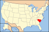
 Location of Beaufort County in South Carolina
This is a list of the National Register of Historic Places listings in Beaufort County, South Carolina.
This is intended to be a complete list of the properties and districts on the National Register of Historic Places in Beaufort County, South Carolina, United States. The locations of National Register properties and districts for which the latitude and longitude coordinates are included below, may be seen on a map.[1]
There are 69 properties and districts listed on the National Register in the county, including 5 National Historic Landmarks.
-
- This National Park Service list is complete through NPS recent listings posted November 10, 2011.[2]
Current listings
[3] Landmark name [4] Image Date listed Location City or town Summary 1 Emanuel Alston House October 6, 1988 Secondary Road 161, 0.25 miles north of its junction with U.S. Route 21
32°24′11″N 80°33′32″W / 32.403056°N 80.558889°WFrogmore 2 Altamaha Town January 21, 1994 Address Restricted Bluffton 3 The Anchorage November 23, 1971 1103 Bay St.
32°25′56″N 80°40′27″W / 32.432222°N 80.674167°WBeaufort 4 Dr. York Bailey House October 6, 1988 U.S. Route 21, approximately 0.2 miles east of its junction with Lands End Rd.
32°23′52″N 80°34′27″W / 32.397778°N 80.574167°WFrogmore 5 William Barnwell House March 24, 1971 800 Prince St.
32°26′06″N 80°40′21″W / 32.435°N 80.6725°WBeaufort 6 Barnwell-Gough House 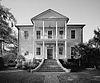
November 15, 1972 705 Washington St.
32°26′13″N 80°40′21″W / 32.436944°N 80.6725°WBeaufort 7 Beaufort Historic District 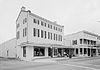
December 17, 1969 Bounded by the Beaufort River and Bladen, Hamar, and Boundary Sts.
32°26′08″N 80°40′04″W / 32.435556°N 80.667778°WBeaufort 8 Beaufort National Cemetery 
October 10, 1997 1601 Boundary St.
32°25′55″N 80°40′49″W / 32.431944°N 80.680278°WBeaufort 9 Bluffton Historic District June 21, 1996 Roughly bounded by the May River, Huger Cove, and Bridge St.
32°13′57″N 80°51′49″W / 32.2325°N 80.863611°WBluffton 10 Camp Saxton Site February 2, 1995 Address Restricted Port Royal 11 Charlesfort-Santa Elena Site 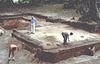
August 7, 1974 Address Restricted Beaufort 12 Chester Field October 15, 1970 Address Restricted Laurel Bay 13 Church of the Cross May 29, 1975 Calhoun St.
32°13′52″N 80°51′52″W / 32.231111°N 80.864444°WBluffton 14 Coffin Point Plantation August 28, 1975 3 miles east of Frogmore at the northeastern end of Seaside Rd. on St. Helena Island
32°25′58″N 80°28′32″W / 32.432778°N 80.475556°WFrogmore 15 Coffin Point Plantation Caretaker's House May 28, 1989 Adjacent to Coffin Point Plantation, off Seaside Rd.
32°26′08″N 80°28′24″W / 32.435556°N 80.473333°WFrogmore 16 The Corner Packing Shed October 6, 1988 U.S. Route 21, west of its junction with Land's End Rd.
32°23′51″N 80°34′34″W / 32.3975°N 80.576111°WFrogmore 17 The Corner Store and Office October 6, 1988 U.S. Route 21, west of its junction with Lands End Rd.
32°23′48″N 80°34′43″W / 32.396667°N 80.578611°WFrogmore 18 John A. Cuthbert House 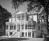
June 13, 1972 1203 Bay St.
32°25′57″N 80°40′32″W / 32.4325°N 80.675556°WBeaufort 19 Daufuskie Island Historic District June 2, 1982 Southwest of Hilton Head
32°06′47″N 80°51′59″W / 32.113056°N 80.866389°WHilton Head Island 20 Eddings Point Community Praise House May 19, 1989 On Secondary Road 183, 0.1 miles north of its junction with Secondary Road 74
32°26′36″N 80°32′38″W / 32.443333°N 80.543889°WFrogmore 21 Fish Haul Archaeological Site (38BU805) June 30, 1988 Address Restricted Hilton Head Island 22 Fort Frederick Heritage Preserve December 31, 1974 Address Restricted Port Royal 23 Fort Fremont Battery May 5, 2010 Bay Point Rd., 0.3 miles from Land's End Rd.32°18′22″N 80°38′32″W / 32.30611°N 80.64222°W Frogmore 24 Fort Fremont Hospital May 26, 1989 0.3 miles from Land's End Rd.
32°18′29″N 80°38′37″W / 32.308056°N 80.643611°WFrogmore 25 Fort Howell June 15, 2011 North side of Beach City Rd. approximately 200 ft. southwest of the junction with Dillon Rd.
32°14′04″N 80°41′31″W / 32.234444°N 80.691944°WHilton Head Civil War earthwork fortification built in 1864 by the 32nd United States Colored Infantry Regiment and the 144th New York Infantry[5] 26 Fort Lyttelton Site September 13, 1979 Address Restricted Beaufort 27 Edgar Fripp Mausoleum, St. Helena Island Parish Church October 6, 1988 Secondary Road 45 near its junction with Secondary Road 37
32°22′30″N 80°34′34″W / 32.375°N 80.576111°WFrogmore 28 Isaac Fripp House Ruins October 6, 1988 On an unpaved road, 1.1 miles west of its junction with Secondary Road 45
32°20′37″N 80°38′25″W / 32.343611°N 80.640278°WFrogmore 29 Frogmore Plantation Complex 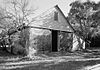
May 26, 1989 Off Secondary Road 77 near its junction with Secondary Road 35
32°21′32″N 80°33′40″W / 32.358889°N 80.561111°WFrogmore 30 Green's Shell Enclosure August 7, 1974 Address Restricted Hilton Head Island 31 The Green October 6, 1988 Southeastern corner of the intersection of U.S. Route 21 and Lands End Rd.
32°23′46″N 80°34′37″W / 32.396111°N 80.576944°WFrogmore 32 Hasell Point Site August 14, 1973 Address Restricted Port Royal 33 Hunting Island State Park Lighthouse 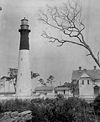
June 5, 1970 17 miles south-southwest of Beaufort on U.S. Route 21
32°22′32″N 80°26′16″W / 32.375556°N 80.437778°WBeaufort 34 Indian Hill Site March 22, 1974 Address Restricted St. Helena Island 35 Mary Jenkins Community Praise House May 19, 1989 On Secondary Road 74, 2.1 miles north of its junction with U.S. Route 21
32°25′47″N 80°33′38″W / 32.429722°N 80.560556°WFrogmore 36 Knights of Wise Men Lodge April 12, 1996 Martin Luther King Dr., south of its junction with U.S. Route 21
32°23′43″N 80°33′58″W / 32.395278°N 80.566111°WSt. Helena Island 37 Lands End Road Tabby Ruins October 6, 1988 Address Restricted Frogmore 38 Laurel Bay Plantation February 27, 1997 Address Restricted Beaufort 39 Little Barnwell Island August 14, 1973 North of Port Royal
32°30′06″N 80°47′25″W / 32.501667°N 80.790278°WPort Royal 40 Marshlands 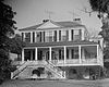
November 7, 1973 501 Pinckney St.
32°25′59″N 80°39′56″W / 32.433056°N 80.665556°WBeaufort 41 McLeod Farmstead July 25, 1997 Seabrook Rd., 1 mile west of U.S. Route 21 and 10 miles north of Beaufort
32°31′40″N 80°45′56″W / 32.527778°N 80.765556°WSeabrook 42 The Oaks October 6, 1988 On an unpaved road, 0.3 miles west of Secondary Road 165
32°23′21″N 80°37′12″W / 32.389167°N 80.62°WFrogmore 43 Old Brass 
June 3, 1976 East of Yemassee on River Rd.
32°41′00″N 80°48′30″W / 32.683333°N 80.808333°WYemassee 44 Orange Grove Plantation May 26, 1989 Overlooking Wallace Creek, 0.25 mi. from South Carolina Highway 113
32°22′13″N 80°36′14″W / 32.370278°N 80.603889°WFrogmore 45 Parris Island Drydock and Commanding Generals House November 21, 1978 Mexico and Tripoli Sts.
32°21′00″N 80°40′18″W / 32.35°N 80.671667°WParris Island 46 Penn Center Historic District 
September 9, 1974 South of Frogmore on South Carolina Highway 37
32°23′16″N 80°34′44″W / 32.387778°N 80.578889°WFrogmore 47 Pine Island Plantation Complex May 26, 1989 Pine Island
32°26′25″N 80°30′38″W / 32.440278°N 80.510556°WFrogmore 48 Pocosobo Town January 21, 1994 Address Restricted Sheldon 49 Rear Lighthouse of Hilton Head Range Light Station December 12, 1985 Arthur Hill Golf Course, Palmetto Dunes Resort off U.S. Route 278
32°09′51″N 80°44′24″W / 32.164167°N 80.74°WHilton Head Island 50 Riverside Plantation Tabby Ruins October 6, 1988 On an unpaved road., 0.4 miles west of Secondary Road 45 at Lands End
32°18′57″N 80°38′38″W / 32.315833°N 80.643889°WFrogmore 51 Rose Hill Plantation House 
May 19, 1983 Off U.S. Route 278
32°17′42″N 80°52′31″W / 32.295°N 80.875278°WBluffton 52 St. Helena Parish Chapel of Ease Ruins October 6, 1988 Secondary Road 45, near its junction with Secondary Road 37
32°22′31″N 80°34′36″W / 32.375278°N 80.576667°WFrogmore 53 St. Helenaville Archaeological Site (38BU931) October 6, 1988 Address Restricted Frogmore 54 St. Luke's Church November 10, 1987 South Carolina Highway 170
32°16′24″N 80°57′00″W / 32.273333°N 80.95°WPritchardville 55 Sams Plantation Complex Tabby Ruins March 4, 2011 Southern end of Dataw (Datha) Island near the intersection of Dataw Dr. and Dataw Club Rd., at Mink's Point near Jenkins Creek
32°25′51″N 80°35′04″W / 32.430833°N 80.584444°WFrogmore Ruins of late-18th/early-19th century tabby plantation complex; originally listed as "Sams Tabby Complex (38BU581)"[6] 56 F.W. Scheper Store June 22, 2004 918 8th St.
32°22′29″N 80°41′34″W / 32.374722°N 80.692778°WPort Royal 57 Sea Pines October 15, 1970 Address Restricted Hilton Head Island A prehistoric shell midden on Hilton Head Island. 58 Seacoast Packing Company June 17, 2008 100 Dill Dr. Beaufort 59 Seaside Plantation July 16, 1979 10 miles east of Beaufort on U.S. Route 21
32°21′02″N 80°34′13″W / 32.350556°N 80.570278°WBeaufort 60 Sheldon Church Ruins 
October 22, 1970 Northwest of Gardens Corner on U.S. Route 21
32°37′03″N 80°42′31″W / 32.6175°N 80.708611°WGardens Corner 61 Robert Simmons House October 6, 1988 On an unpaved road, 0.5 miles south of U.S. Route 21
32°23′29″N 80°36′15″W / 32.391389°N 80.604167°WFrogmore 62 Skull Creek November 10, 1970 Address Restricted Hilton Head Island 63 Robert Smalls House 
May 30, 1974 511 Prince St.
32°26′07″N 80°40′06″W / 32.435278°N 80.668333°WBeaufort 64 Hilton Head Island 65 Stoney-Baynard Plantation February 23, 1994 Junction of Baynard Park Rd. and Plantation Dr.
32°07′44″N 80°48′53″W / 32.128889°N 80.814722°WHilton Head Island 66 Tabby Manse 
May 14, 1971 1211 Bay St.
32°25′58″N 80°40′35″W / 32.432778°N 80.676389°WBeaufort 67 Tombee Plantation September 18, 1975 South of Frogmore on St. Helena's Island
32°18′31″N 80°37′25″W / 32.308611°N 80.623611°WFrogmore 68 Union Church of Port Royal November 17, 2010 1004 11th St.
32°22′37″N 80°41′35″W / 32.376944°N 80.693056°WPort Royal 69 John Mark Verdier House 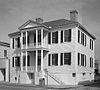
August 19, 1971 801 Bay St.
32°25′50″N 80°40′16″W / 32.430556°N 80.671111°WBeaufort See also
- List of National Historic Landmarks in South Carolina
- National Register of Historic Places listings in South Carolina
References
- ^ The latitude and longitude information provided in this table was derived originally from the National Register Information System, which has been found to be fairly accurate for about 99% of listings. For about 1% of NRIS original coordinates, experience has shown that one or both coordinates are typos or otherwise extremely far off; some corrections may have been made. A more subtle problem causes many locations to be off by up to 150 yards, depending on location in the country: most NRIS coordinates were derived from tracing out latitude and longitudes off of USGS topographical quadrant maps created under the North American Datum of 1927, which differs from the current, highly accurate WGS84 GPS system used by Google maps. Chicago is about right, but NRIS longitudes in Washington are higher by about 4.5 seconds, and are lower by about 2.0 seconds in Maine. Latitudes differ by about 1.0 second in Florida. Some locations in this table may have been corrected to current GPS standards.
- ^ "National Register of Historic Places: Weekly List Actions". National Park Service, United States Department of the Interior. Retrieved on November 10, 2011.
- ^ Numbers represent an ordering by significant words. Various colorings, defined here, differentiate National Historic Landmark sites and National Register of Historic Places Districts from other NRHP buildings, structures, sites or objects.
- ^ "National Register Information System". National Register of Historic Places. National Park Service. . http://nrhp.focus.nps.gov/natreg/docs/All_Data.html.
- ^ "National Register of Historic Places Registration Form - Fort Howell". April 21, 2011. http://www.nationalregister.sc.gov/beaufort/S10817707070/S10817707070.pdf. Retrieved July 7, 2011.
- ^ "National Register of Historic Places Registration Form - Sams Tabby Complex". February 15, 1988. http://www.nationalregister.sc.gov/beaufort/S10817707069/S10817707069.pdf. Retrieved July 7, 2011.
U.S. National Register of Historic Places in South Carolina Lists by county Abbeville • Aiken • Allendale • Anderson • Bamberg • Barnwell • Beaufort • Berkeley • Calhoun • Charleston • Cherokee • Chester • Chesterfield • Clarendon • Colleton • Darlington • Dillon • Dorchester • Edgefield • Fairfield • Florence • Georgetown • Greenville • Greenwood • Hampton • Horry • Jasper • Kershaw • Lancaster • Laurens • Lee • Lexington • Marion • Marlboro • McCormick • Newberry • Oconee • Orangeburg • Pickens • Richland • Saluda • Spartanburg • Sumter • Union • Williamsburg • York
Lists by city Other lists Municipalities and communities of Beaufort County, South Carolina City 
Towns Bluffton | Hilton Head Island | Port Royal | Hardeeville‡ | Yemassee‡
CDPs Unincorporated
communitiesFrogmore | Pritchardville | Sheldon
Footnotes ‡This populated place also has portions in an adjacent county or counties
The Lowcountry of South Carolina Counties 
Major communities Beaufort • Bluffton • Estill • Hampton • Hardeeville • Hilton Head Island • Port Royal • Ridgeland • Walterboro • Varnville • YemasseeSea Islands Daufuskie Island • Edisto Island • Fripp Island • Harbor Island • Hilton Head Island • Hunting Island • Lady's Island • St. Helena IslandHistory & culture Historic places • Beaufort (history of - historic district) • Cuisine • Gullah culture • Port Royal Experiment • Sea Islands HurricaneMilitary installations Natural areas ACE Basin • Hunting Island State Park & Lighthouse • Pinckney Island NWR • Savannah NWR • Sea IslandsOther articles Categories:- Beaufort County, South Carolina
- National Register of Historic Places in South Carolina by county
- Buildings and structures in Beaufort County, South Carolina
-


Wikimedia Foundation. 2010.