- National Register of Historic Places listings in Bedford County, Pennsylvania
-
 Location of Bedford County in Pennsylvania
This is a list of the National Register of Historic Places listings in Bedford County, Pennsylvania.
This is intended to be a complete list of the properties and districts on the National Register of Historic Places in Bedford County, Pennsylvania, United States. The locations of National Register properties and districts for which the latitude and longitude coordinates are included below, may be seen in a Google map.[1]
There are 31 properties and districts listed on the National Register in the county. Three sites are further designated as National Historic Landmarks. Another 2 properties were once listed but have been removed.
-
- This National Park Service list is complete through NPS recent listings posted November 10, 2011.[2]
Current listings
[3] Landmark name Image Date listed Location City or town Summary 1 Barclay House 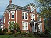
September 18, 1978 230 Juliana Street
40°00′57″N 78°30′16″W / 40.015833°N 78.504444°WBedford 2 Bedford County Alms House November 3, 1988 Cumberland Road, .4 miles (0.64 km) south of Bedford
39°59′13″N 78°32′32″W / 39.986944°N 78.542222°WBedford Township 3 Bedford Historic District 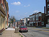
December 22, 1983 Roughly bounded by East, West, and Watson Streets, and the Raystown Branch of the Juniata River
40°01′03″N 78°29′49″W / 40.0175°N 78.496944°WBedford 4 Bedford Springs Hotel Historic District 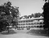
December 20, 1984 U.S. Route 220, south of Bedford
39°59′10″N 78°31′08″W / 39.986111°N 78.518889°WBedford Township 5 Bonnet's Tavern 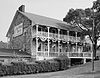
August 1, 1979 4 miles (6.4 km) west of Bedford at the junction of U.S. Route 30 and Pennsylvania Route 31
40°02′32″N 78°33′39″W / 40.042222°N 78.560833°WNapier Township 6 Bridge in Snake Spring Township 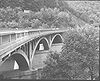
June 22, 1988 Township Road 30 over the Raystown Branch of the Juniata River, east of Bedford
40°00′49″N 78°28′18″W / 40.013611°N 78.471667°WSnake Spring Township 7 Chalybeate Springs Hotel July 18, 1985 Chalybeate Road, north of Bedford
40°01′31″N 78°28′35″W / 40.025278°N 78.476389°WBedford Township 8 Chestnut Ridge and Schellsburg Union Church and Cemetery 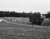
January 12, 2005 U.S. Route 30
40°02′55″N 78°39′21″W / 40.048611°N 78.655833°WNapier Township 9 The Coffee Pot 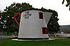
February 24, 2005 Business Route 30
40°01′23″N 78°31′02″W / 40.022917°N 78.517361°WBedford Township 10 Defibaugh Tavern November 12, 1992 Northern side of U.S. Route 30, east of Bedford
40°01′34″N 78°27′10″W / 40.026111°N 78.452778°WSnake Spring Township 11 Diehls Covered Bridge 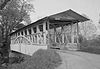
April 10, 1980 South of Schellsburg on Legislative Route 09057, east of New Buena Vista
40°00′34″N 78°38′55″W / 40.009444°N 78.648611°WHarrison Township 12 East Broad Top Railroad 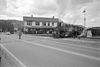
October 15, 1966 1 mile (1.6 km) west of Orbisonia on U.S. Route 522 Broad Top Township Extends into multiple municipalities in Huntingdon County 13 Espy House 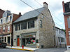
November 19, 1974 123 Pitt Street
40°01′10″N 78°30′11″W / 40.019444°N 78.503056°WBedford 14 Everett Historic District 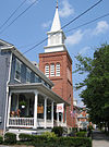
May 29, 2003 Roughly bounded by West 5th, Borough, and Hill Streets, River Lane, South Street, and Barndollar Avenue
40°00′47″N 78°22′19″W / 40.013056°N 78.371944°WEverett 15 Feltons Mill Covered Bridge 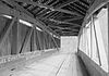
April 10, 1980 Legislative Route 05021, east of Bedford
39°58′22″N 78°17′20″W / 39.972778°N 78.288889°WEast Providence Township 16 Fischtner Covered Bridge April 10, 1980 North of Stringtown off Legislative Route 05007
39°45′49″N 78°45′06″W / 39.763611°N 78.751667°WLondonderry Township 17 Halls Mill Covered Bridge 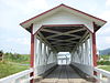
April 10, 1980 North of Everett on Township 528
40°07′27″N 78°19′02″W / 40.124167°N 78.317222°WHopewell Township 18 Heirline Covered Bridge April 10, 1980 West of Bedford on Legislative Route 05097, north of Manns Choice
40°01′00″N 78°35′37″W / 40.016667°N 78.593611°WHarrison and Napier Townships 19 Hewitt Covered Bridge April 10, 1980 Township 305 at Hewitt
39°45′16″N 78°30′40″W / 39.754444°N 78.511111°WSouthampton Township 20 Jacksons Mill Covered Bridge 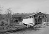
April 10, 1980 Township 412, east of Bedford
39°58′16″N 78°16′19″W / 39.971111°N 78.271944°WEast Providence Township 21 Juniata Woolen Mill and Newry Manor 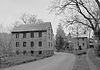
March 31, 1983 West of Everett on Lutzville Road
40°00′54″N 78°25′50″W / 40.015°N 78.430556°WSnake Spring Township 22 Dr. Knisley Covered Bridge April 10, 1980 Southeast of Alum Bank on Legislative Route 05098
40°09′36″N 78°36′08″W / 40.16°N 78.602222°WWest St. Clair Township 23 New Enterprise Public School October 8, 1981 Off Pennsylvania Route 869 at New Enterprise
40°10′17″N 78°24′28″W / 40.171389°N 78.407778°WSouth Woodbury Township 24 New Paris Covered Bridge April 10, 1980 1 mile (1.6 km) north of New Paris
40°06′58″N 78°38′23″W / 40.116111°N 78.639722°WNapier Township 25 Osterburg Covered Bridge April 10, 1980 West of Osterburg on Township 757
40°10′37″N 78°32′30″W / 40.176944°N 78.541667°WEast St. Clair Township 26 Russell House 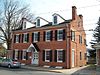
June 19, 1979 203 South Juliana Street
40°01′00″N 78°30′14″W / 40.016667°N 78.503889°WBedford 27 Ryot Covered Bridge April 10, 1980 South of Alum Bank on Township 559, northwest of Fishertown
40°08′32″N 78°37′30″W / 40.142222°N 78.625°WWest St. Clair Township 28 Schellsburg Historic District June 21, 2001 Approximately centered on Pitt Street, Market and Baltimore Streets
40°02′52″N 78°38′35″W / 40.047778°N 78.643056°WSchellsburg 29 Site 36BD90 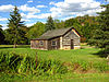
June 4, 1984 On the grounds of Bedford Village
40°2′31.2″N 78°30′38.412″W / 40.042°N 78.51067°W[4]Bedford Township 30 Snooks Covered Bridge April 10, 1980 East of Alum Bank on Township 578
40°10′09″N 78°34′48″W / 40.169167°N 78.58°WEast St. Clair Township 31 Woodvale Historic District July 24, 1992 Roughly bounded by Ash, High, North, Fulton, and Broad Streets in Woodvale
40°10′01″N 78°08′17″W / 40.166944°N 78.138056°WBroad Top Township Extends into Wells Township in Fulton County and Wood Township in Huntingdon County Former listings
[3] Landmark name Image Date listed Location City or town Summary 1 Grand View Point Hotel 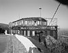
January 14, 2002 U.S. Route 30, 17 miles (27 km) west of Bedford, Juniata Township Juniata Township Built 1932
Burned 20012 McDaniels Covered Bridge October 13, 1988 Address Restricted East Providence Township and West Providence Township Listed on April 10, 1980 See also
- List of National Historic Landmarks in Pennsylvania
- National Register of Historic Places listings in Pennsylvania
- List of Pennsylvania state historical markers in Bedford County
References
- ^ The latitude and longitude information provided in this table was derived originally from the National Register Information System, which has been found to be fairly accurate for about 99% of listings. For about 1% of NRIS original coordinates, experience has shown that one or both coordinates are typos or otherwise extremely far off; some corrections may have been made. A more subtle problem causes many locations to be off by up to 150 yards, depending on location in the country: most NRIS coordinates were derived from tracing out latitude and longitudes off of USGS topographical quadrant maps created under the North American Datum of 1927, which differs from the current, highly accurate WGS84 GPS system used by Google maps. Chicago is about right, but NRIS longitudes in Washington are higher by about 4.5 seconds, and are lower by about 2.0 seconds in Maine. Latitudes differ by about 1.0 second in Florida. Some locations in this table may have been corrected to current GPS standards.
- ^ "National Register of Historic Places: Weekly List Actions". National Park Service, United States Department of the Interior. Retrieved on November 10, 2011.
- ^ Numbers represent an ordering by significant words. Various colorings, defined here, differentiate National Historic Landmark sites and National Register of Historic Places Districts from other NRHP buildings, structures, sites or objects.
- ^ Location derived from its NRHP nomination form; the NRIS lists the site as "Address Restricted"
Municipalities and communities of Bedford County, Pennsylvania Boroughs Bedford | Coaldale | Everett | Hopewell | Hyndman | Manns Choice | New Paris | Pleasantville | Rainsburg | St. Clairsville | Saxton | Schellsburg | Woodbury

Townships Bedford | Bloomfield | Broad Top | Colerain | Cumberland Valley | East Providence | East St. Clair | Harrison | Hopewell | Juniata | Kimmel | King | Liberty | Lincoln | Londonderry | Mann | Monroe | Napier | Pavia | Snake Spring | South Woodbury | Southampton | West Providence | West St. Clair | Woodbury
Unincorporated
communitiesBreezewood | Chaneysville | Defiance | Loysburg | Mount Dallas | Osterburg | Riddlesburg | State Line
Categories:- National Register of Historic Places in Pennsylvania by county
- Bedford County, Pennsylvania
-


Wikimedia Foundation. 2010.