- National Register of Historic Places listings in Belmont County, Ohio
-
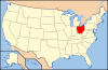
 Location of Belmont County in Ohio
This is a list of the National Register of Historic Places listings in Belmont County, Ohio.
This is intended to be a complete list of the properties and districts on the National Register of Historic Places in Belmont County, Ohio, United States. The locations of National Register properties and districts for which the latitude and longitude coordinates are included below, may be seen in a Google map.[1]
There are 24 properties and districts listed on the National Register in the county. Another property was once listed but has been removed.
-
- This National Park Service list is complete through NPS recent listings posted November 10, 2011.[2]
Current listings
[3] Landmark name [4] Image Date listed Location City or town Summary 1 B & O Railroad Viaduct 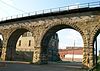
June 22, 1976 31st St.
40°00′47″N 80°44′40″W / 40.013056°N 80.744444°WBellaire Extends into Benwood in Marshall County, West Virginia 2 Barnesville Baltimore and Ohio Railroad Depot 
August 8, 1985 300 E. Church St.
39°59′19″N 81°10′24″W / 39.988611°N 81.173333°WBarnesville 3 Barnesville Historic District 
July 19, 1984 Roughly bounded by Arch, Main, Gardner, Chestnut, Bond, and Cherry Sts.
39°59′16″N 81°10′38″W / 39.987778°N 81.177361°WBarnesville 4 Barnesville Petroglyph 
July 15, 1974 Off Track Rocks Road, southwest of Barnesville
39°58′37″N 81°13′54″W / 39.97694°N 81.23167°W[5]Warren Township 5 Belleview Heights 
April 8, 1994 65100 Candlewick Ln.
40°01′41″N 80°44′37″W / 40.028056°N 80.743611°WBellaire 6 Belmont Historic District 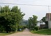
March 13, 1987 Roughly bounded by Barrister, John, Jefferson, Sycamore, and Bridge Sts.
40°01′46″N 81°02′25″W / 40.029444°N 81.040139°WBelmont 7 Blaine Hill "S" Bridge 
March 17, 2010 Township Road 649 at Blaine
40°04′01″N 80°49′15″W / 40.066922°N 80.820969°WPease Township 385 foot long bridge with three stone arches; built in 1828; oldest standing bridge in Ohio[6] 8 Brick Tavern House 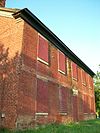
November 22, 1995 U.S. Route 40 west of St. Clairsville
40°04′25″N 80°58′58″W / 40.073611°N 80.982778°WRichland Township 9 Brokaw Site 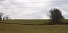
June 17, 1976 Off Brokaw Dr., southwest of St. Clairsville
40°4′4″N 80°55′56.1″W / 40.06778°N 80.93225°W[7]Richland Township 10 Concord Hicksite Friends Meeting House 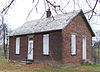
July 23, 2009 Negus Rd.
40°07′31″N 80°47′45″W / 40.12517°N 80.79576°WColerain Township 11 Finney-Darrah House March 15, 1982 Scenary Hill
40°06′02″N 80°44′22″W / 40.100556°N 80.739444°WMartins Ferry 12 Friends Boarding School and Ohio Yearly Meetinghouse Historic District 
March 25, 2009 61830 Sandy Ridge Rd., east of Barnesville
39°59′18″N 81°09′09″W / 39.988222°N 81.152386°WWarren Township 13 Thomas T. and Wesley B. Frasier Houses 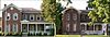
November 17, 1982 898 and 920 National Rd.
40°04′15″N 80°45′35″W / 40.070833°N 80.759722°WBrookside 14 Great Western Schoolhouse 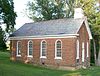
May 7, 1979 West of St. Clairsville on U.S. Route 40
40°04′22″N 80°58′52″W / 40.072778°N 80.981111°WRichland Township 15 Imperial Glass Company 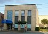
September 8, 1983 29th and Belmont Sts.
40°00′41″N 80°44′49″W / 40.011389°N 80.746944°WBellaire 16 James Kinney Farmstead 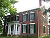
April 29, 1999 44680 Belmont-Centerville Rd., southeast of Belmont
39°59′50″N 80°59′38″W / 39.997222°N 80.99375°WSmith Township 17 Joseph Kirkwood House 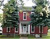
February 13, 1986 329 Bennett St.
40°04′08″N 80°44′39″W / 40.068889°N 80.744167°WBridgeport 18 Morristown Historic District 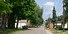
March 6, 1980 Church, Main, W. Cross, E. Cross, and Middle Cross Sts.
40°03′51″N 81°04′22″W / 40.064167°N 81.072778°WMorristown 19 Opatrny Village Site May 21, 1975 West of St. Clairsville off Interstate 70.[8] Richland Township 20 Rock Hill Presbyterian Church 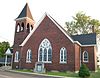
April 1, 2009 56244 High Ridge Rd., northwest of Bellaire
40°02′47″N 80°46′40″W / 40.046425°N 80.777847°WPultney Township 21 St. Clairsville Historic District 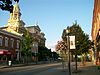
March 17, 1994 E. and W. Main St. between Butler and Sugar Sts.
40°04′50″N 80°54′02″W / 40.080556°N 80.900556°WSt. Clairsville 22 Dr. Lindley Schooley House and Office 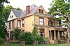
April 1, 1982 Main St.
40°01′45″N 81°02′31″W / 40.029167°N 81.041944°WBelmont 23 Tower Site 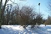
June 11, 1982 On a hilltop 4 miles northwest of Barnesville
40°1′23″N 81°13′16″W / 40.02306°N 81.22111°W[9]Warren Township 24 Zweig Building 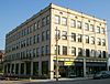
January 28, 2000 3396 Belmont St.
40°01′07″N 80°44′32″W / 40.018611°N 80.742222°WBellaire Former listing
[3] Landmark name Image Date listed Location City or town Summary 1 Central School 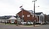
July 23, 1979 Junction of Hickory and S. 4th Sts.
40°5′41.45″N 80°43′31.5″W / 40.0948472°N 80.725417°WMartins Ferry Delisted on February 21, 1980; Destroyed See also
References
- ^ The latitude and longitude information provided in this table was derived originally from the National Register Information System, which has been found to be fairly accurate for about 99% of listings. For about 1% of NRIS original coordinates, experience has shown that one or both coordinates are typos or otherwise extremely far off; some corrections may have been made. A more subtle problem causes many locations to be off by up to 150 yards, depending on location in the country: most NRIS coordinates were derived from tracing out latitude and longitudes off of USGS topographical quadrant maps created under the North American Datum of 1927, which differs from the current, highly accurate WGS84 GPS system used by Google maps. Chicago is about right, but NRIS longitudes in Washington are higher by about 4.5 seconds, and are lower by about 2.0 seconds in Maine. Latitudes differ by about 1.0 second in Florida. Some locations in this table may have been corrected to current GPS standards.
- ^ "National Register of Historic Places: Weekly List Actions". National Park Service, United States Department of the Interior. Retrieved on November 10, 2011.
- ^ a b Numbers represent an ordering by significant words. Various colorings, defined here, differentiate National Historic Landmark sites and National Register of Historic Places Districts from other NRHP buildings, structures, sites or objects.
- ^ "National Register Information System". National Register of Historic Places. National Park Service. . http://nrhp.focus.nps.gov/natreg/docs/All_Data.html.
- ^ Location derived from Swauger, James L. Rock Art of the Upper Ohio Valley. Graz: Akademische Druck und Verlagsanstalt, 1974, 115. The NRIS lists the site as "Address Restricted".
- ^ Wright, D.K. (May 18, 2010). "Old Blaine Hill S-Bridge Makes National Register of Historic Places". The State Journal (Charleston, West Virginia: West Virginia Media Holdings, LLC). http://www.statejournal.com/story.cfm?func=viewstory&storyid=80010. Retrieved May 18, 2010.
- ^ Location derived from Pickenpaugh, Thomas E. "The Brokaw Site (33-Bl-6) — A Preliminary Report". Ohio Archaeologist 24 (1974): 40. The NRIS lists the site as "Address Restricted".
- ^ Location derived from The National Register of Historic Places. Vol. 2. Washington: National Park Service, 1976, 398. The NRIS lists the site as "Address Restricted"
- ^ Location derived from Brown, Jeffrey D. The Tower Site and Ohio Monongahela. Kent: Kent State U, 1981, 3. The NRIS lists the site as "Address Restricted".
National Register of Historic Places in Ohio Lists by county Adams • Allen • Ashland • Ashtabula • Athens • Auglaize • Belmont • Brown • Butler • Carroll • Champaign • Clark • Clermont • Clinton • Columbiana • Coshocton • Crawford • Cuyahoga • Darke • Defiance • Delaware • Erie • Fairfield • Fayette • Franklin • Fulton • Gallia • Geauga • Greene • Guernsey • Hamilton • Hancock • Hardin • Harrison • Henry • Highland • Hocking • Holmes • Huron • Jackson • Jefferson • Knox • Lake • Lawrence • Licking • Logan • Lorain • Lucas • Madison • Mahoning • Marion • Medina • Meigs • Mercer • Miami • Monroe • Montgomery • Morgan • Morrow • Muskingum • Noble • Ottawa • Paulding • Perry • Pickaway • Pike • Portage • Preble • Putnam • Richland • Ross • Sandusky • Scioto • Seneca • Shelby • Stark • Summit • Trumbull • Tuscarawas • Union • Van Wert • Vinton • Warren • Washington • Wayne • Williams • Wood • Wyandot
Lists by city Other lists Municipalities and communities of Belmont County, Ohio Cities 
Villages Barnesville | Bellaire | Belmont | Bethesda | Bridgeport | Brookside | Fairview‡ | Flushing | Holloway | Morristown | Powhatan Point | Shadyside | Wilson‡ | Yorkville‡
Townships CDP Unincorporated
communitiesFootnotes ‡This populated place also has portions in an adjacent county or counties
Categories:- National Register of Historic Places in Ohio by county
- Belmont County, Ohio
-


Wikimedia Foundation. 2010.